10-Day Weather Forecast - Munson, PA
- |22°FPartly CloudyHourly details
Tonight
22°FPartly cloudy this evening then becoming mostly cloudy. Lows in the lower 20s. North winds 5 to 10 mph with gusts up to 20 mph becoming northeast after midnight.
- 28|26°FFrozen MixHourly details
Day
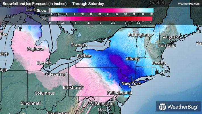
28°FA slight chance of freezing rain in the morning then freezing rain and sleet in the afternoon. Precipitation may be heavy at times in the afternoon. Sleet accumulation up to 1 inch. Ice accumulation of up to one half of an inch. Much colder with highs in the upper 20s. Southeast winds 10 to 15 mph with gusts up to 30 mph. Chance of precipitation near 100 percent.
Night
26°FFreezing rain in the evening. Ice accumulation of a tenth to one quarter of an inch. Lows in the mid 20s. Southeast winds 5 to 10 mph with gusts up to 25 mph becoming west after midnight. Chance of precipitation 90 percent.
Weekend Weather
- 36|25°FPartly SunnyHourly details
Day
36°FMostly cloudy in the morning then becoming partly sunny. Highs in the mid 30s. Northwest winds around 5 mph.
Night
25°FMostly cloudy. Lows in the mid 20s. Southeast winds around 5 mph.
- 36|35°F80% Chance Freezing RainHourly details
Day
36°FCloudy. A chance of rain showers and freezing rain in the morning then rain showers in the afternoon. Highs in the lower 40s. Chance of precipitation 80 percent.
Night
35°FRain showers. Not as cool with lows in the mid 30s. Temperature rising into the lower 40s after midnight. Chance of rain near 100 percent.
- 42|18°FFrozen MixHourly details
Day
42°FRain showers in the morning then a chance of rain and snow showers in the afternoon. Highs in the upper 40s. Temperature falling into the lower 30s in the afternoon. Chance of precipitation near 100 percent.
Night
18°FMostly cloudy with a 50 percent chance of snow showers. Blustery and much colder with lows 15 to 20. Wind chill values as low as zero.
- 25|20°F50% Chance Snow ShowersHourly details
Day
25°FMostly cloudy. A chance of snow showers in the morning. Much colder with highs in the mid 20s. Chance of snow 50 percent. Wind chill values as low as zero.
Night
20°FMostly cloudy. Lows 15 to 20. Wind chill values as low as 5 above.
- 26|19°F40% Chance Snow ShowersHourly details
Day
26°FMostly cloudy. A chance of snow showers in the afternoon. Highs in the upper 20s. Chance of snow 40 percent. Wind chill values as low as 5 above.
Night
19°FMostly cloudy. A chance of snow showers after midnight. Lows around 20. Chance of snow 40 percent. Wind chill values as low as 5 above.
- 29|20°FMostly Cloudy
Day
29°FMostly cloudy. Highs in the upper 20s. Wind chill values as low as 5 above.
Night
20°FMostly clear. Low temperature around 20F. Dew point will be around 15F with an average humidity of 75%. Winds will be 5 mph from the W.
- 31|23°FCloudy
Day
31°FCloudy. High temperature around 31F. Dew point will be around 18F with an average humidity of 70%. Winds will be 5 mph from the W.
Night
23°FPartly cloudy. Low temperature around 23F. Dew point will be around 20F with an average humidity of 81%. Winds will be 2 mph from the S.
Weekend Weather
- 32|28°F30% Chance Frozen Mix
Day
32°FCloudy with a slight chance of rain-snow mix. Chance of precipitation 30%. High temperature around 32F. Dew point will be around 23F with an average humidity of 78%. Winds will be 3 mph from the S.
Night
28°FCloudy with a chance of snow. Chance of precipitation 40%. Low temperature around 28F. Dew point will be around 26F with an average humidity of 86%. Winds will be 3 mph from the S.