---
title: 2025 Atlantic Hurricane Season Set to Ramp Up | WeatherBug | WeatherBug
description: As the peak of the Atlantic hurricane season arrives, indicators suggest an active period is ahead.
canonical: https://www.weatherbug.com/news/2025-Atlantic-Hurricane-Season-Set-to-Ramp-Up
og:title: 2025 Atlantic Hurricane Season Set to Ramp Up | WeatherBug | WeatherBug
og:description: As the peak of the Atlantic hurricane season arrives, indicators suggest an active period is ahead.
og:url: https://www.weatherbug.com/news/2025-Atlantic-Hurricane-Season-Set-to-Ramp-Up
og:site_name: WeatherBug
og:locale: en_US
og:image: https://cms-assets-con.cdn.weatherbug.net/assets/contentitems/ff/ff7501e0-717d-4c42-b4fa-d6ec01b4d2d0/52e0ce98-d40a-4283-82d1-d0fe816ebf4b/81fdd67b-c6bf-4ea0-ad03-066689ca665b.jpg
og:image:width: 800
og:image:height: 600
og:image:alt: 2025 AEM Atlantic Hurricane Forecast
og:type: article
article:published_time: 2025-08-23T20:18:54Z
article:modified_time: 2025-08-23T20:18:54Z
article:author: By WeatherBug Meteorologists
article:tag: Atlantic
article:tag: hurricane
article:tag: outlook
article:tag: update
twitter:card: summary_large_image
twitter:title: 2025 Atlantic Hurricane Season Set to Ramp Up | WeatherBug
twitter:description: As the peak of the Atlantic hurricane season arrives, indicators suggest an active period is ahead.
twitter:image: https://cms-assets-con.cdn.weatherbug.net/assets/contentitems/ff/ff7501e0-717d-4c42-b4fa-d6ec01b4d2d0/52e0ce98-d40a-4283-82d1-d0fe816ebf4b/81fdd67b-c6bf-4ea0-ad03-066689ca665b.jpg
---
[](/)
[Back to forecast](/)
# 2025 Atlantic Hurricane Season Set to Ramp Up
August 23, 2025 at 04:18 PM EDT
By WeatherBug Meteorologists
As the peak of the Atlantic hurricane season arrives, primary tropical cyclone development indicators suggest an active period is ahead.
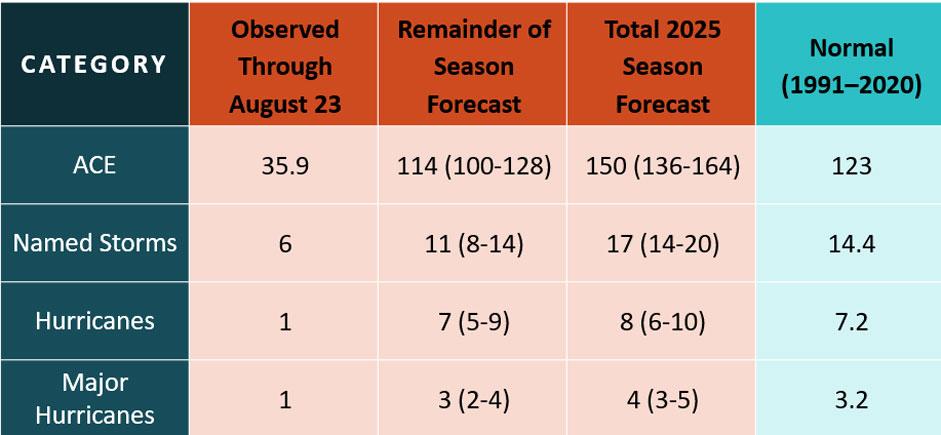
Six named storms have formed so far, with Erin becoming the first major hurricane of the season, reaching Category Five strength. The season has produced one hurricane and one major hurricane, which is slightly above the long-term average for this point in the season.
Accumulated Cyclone Energy (ACE) for the 2025 season stands at 35.9 units as of August 23, about 61% above the climatological average of 22.3 for this date. That places 2025 at 13th out of 75 years since 1951 in terms of ACE to date.
The ACE metric, which accounts for both the intensity and duration of tropical cyclones, is a key indicator of seasonal activity. This year is on pace to meet the seasonal forecast outlook issued by AEM (Advanced Environmental Monitoring) in May, which called for a slightly above-normal hurricane season: 14 to 20 named storms, six to ten hurricanes, and three to five of those major hurricanes.
Between 1991 and 2020, the Atlantic Hurricane Basin produced an average of 14.4 named storms, 7.2 hurricanes and 3 major hurricanes per year.
From late August onward, the season typically enters its most active phase, peaking around September 10\. On average, the period from late August through November 30 accounts for approximately 70 to 85% of total seasonal activity, 10 to 12 named storms, five to six hurricanes, and two to three major hurricanes.
This year’s elevated activity will continue to be driven by warmer-than-average sea surface temperatures (SSTs), an active West African Monsoon, and cool ENSO-neutral conditions.
In late summer and early fall, the Atlantic Main Development Region (MDR) typically reaches its warmest. SSTs are currently running above average, especially in the Gulf of Mexico, Caribbean, and MDR. Warm SSTs (typically above 80 degrees) will provide heat and moisture needed to sustain deep convection, which is the primary energy source for tropical cyclones.
African Easterly Waves, which emerge from West Africa, often serve as seeds for long-track hurricanes. Late August through September is peak season for these waves. Monsoon rainfall over West Africa has been slightly above average this summer. This trend is expected to persist, with a strong West African Monsoon enhancing tropical wave generation.
SST anomalies across the Niño 3.4 region in the equatorial Pacific Ocean remain below normal, and there are signals weak La Niña may arrive by late fall. La Niña and ENSO-neutral conditions tend to reduce vertical wind shear across the Atlantic. Lower wind shear creates a more favorable environment for tropical systems to organize and intensify. Wind shear across the Atlantic Basin is expected to gradually decline into September, paving the way for increased tropical activity.
With the tropical season heating up, it’s time to prepare for the season. Start organizing portable phone chargers, a radio, batteries, non-perishable food, water and blankets into an evacuation kit now. While fair weather is in your area, take the opportunity to scout out multiple evacuation routes from your area in case your preferred route is traffic-jammed or blocked.
Check with WeatherBug throughout the season for the latest on the tropics.
We use technologies, such as cookies, to analyze your use (i.e., pages visited), to customize content, for our internal analytics purposes and for security and other purposes. By continuing to use this website, you agree to this usage. Please review our [privacy policy](/legal/privacy) for more details as well as for information on how to contact us to object to these activities. [Ad Choices](/legal/privacy#digitaladvertisingandyourchoices)
```json
{"@context":"https://schema.org","@type":"NewsArticle","mainEntityOfPage":{"@type":"WebPage","@id":"https://www.weatherbug.com/news/2025-Atlantic-Hurricane-Season-Set-to-Ramp-Up"},"headline":"2025 Atlantic Hurricane Season Set to Ramp Up","description":"As the peak of the Atlantic hurricane season arrives, indicators suggest an active period is ahead.","image":["https://cms-assets-con.cdn.weatherbug.net/assets/contentitems/ff/ff7501e0-717d-4c42-b4fa-d6ec01b4d2d0/52e0ce98-d40a-4283-82d1-d0fe816ebf4b/81fdd67b-c6bf-4ea0-ad03-066689ca665b.jpg"],"datePublished":"2025-08-23T20:18:54Z","dateModified":"2025-08-23T20:18:54Z","dateCreated":"2025-08-23T20:18:54Z","articleSection":"Weather News","keywords":"Atlantic,hurricane,outlook,update","articleBody":"As the peak of the Atlantic hurricane season arrives, primary tropical cyclone development indicators suggest an active period is ahead.
\r\n
\r\nSix named storms have formed so far, with Erin becoming the first major hurricane of the season, reaching Category Five strength. The season has produced one hurricane and one major hurricane, which is slightly above the long-term average for this point in the season.
\r\n
\r\nAccumulated Cyclone Energy (ACE) for the 2025 season stands at 35.9 units as of August 23, about 61% above the climatological average of 22.3 for this date. That places 2025 at 13th out of 75 years since 1951 in terms of ACE to date.
\r\n
\r\nThe ACE metric, which accounts for both the intensity and duration of tropical cyclones, is a key indicator of seasonal activity. This year is on pace to meet the seasonal forecast outlook issued by AEM (Advanced Environmental Monitoring) in May, which called for a slightly above-normal hurricane season: 14 to 20 named storms, six to ten hurricanes, and three to five of those major hurricanes.
\r\n
\r\nBetween 1991 and 2020, the Atlantic Hurricane Basin produced an average of 14.4 named storms, 7.2 hurricanes and 3 major hurricanes per year.
\r\n
\r\nFrom late August onward, the season typically enters its most active phase, peaking around September 10. On average, the period from late August through November 30 accounts for approximately 70 to 85% of total seasonal activity, 10 to 12 named storms, five to six hurricanes, and two to three major hurricanes.
\r\n
\r\nThis year’s elevated activity will continue to be driven by warmer-than-average sea surface temperatures (SSTs), an active West African Monsoon, and cool ENSO-neutral conditions.
\r\n
\r\nIn late summer and early fall, the Atlantic Main Development Region (MDR) typically reaches its warmest. SSTs are currently running above average, especially in the Gulf of Mexico, Caribbean, and MDR. Warm SSTs (typically above 80 degrees) will provide heat and moisture needed to sustain deep convection, which is the primary energy source for tropical cyclones.
\r\n
\r\nAfrican Easterly Waves, which emerge from West Africa, often serve as seeds for long-track hurricanes. Late August through September is peak season for these waves. Monsoon rainfall over West Africa has been slightly above average this summer. This trend is expected to persist, with a strong West African Monsoon enhancing tropical wave generation.
\r\n
\r\nSST anomalies across the Niño 3.4 region in the equatorial Pacific Ocean remain below normal, and there are signals weak La Niña may arrive by late fall. La Niña and ENSO-neutral conditions tend to reduce vertical wind shear across the Atlantic. Lower wind shear creates a more favorable environment for tropical systems to organize and intensify. Wind shear across the Atlantic Basin is expected to gradually decline into September, paving the way for increased tropical activity.
\r\n
\r\nWith the tropical season heating up, it’s time to prepare for the season. Start organizing portable phone chargers, a radio, batteries, non-perishable food, water and blankets into an evacuation kit now. While fair weather is in your area, take the opportunity to scout out multiple evacuation routes from your area in case your preferred route is traffic-jammed or blocked.
\r\n
\r\nCheck with WeatherBug throughout the season for the latest on the tropics.","author":{"@type":"Person","name":"By WeatherBug Meteorologists","url":"https://www.weatherbug.com"},"publisher":{"@type":"Organization","name":"WeatherBug","logo":{"@type":"ImageObject","url":"https://www.weatherbug.com/images/sharing/f1ff28ba-6f06-4745-a782-011a20397e16.png"}}}
{"@context":"https://schema.org","@type":"WebSite","mainEntityOfPage":{"@type":"WebPage","@id":"https://www.weatherbug.com/news/2025-Atlantic-Hurricane-Season-Set-to-Ramp-Up","relatedLink":"https://www.weatherbug.com/news/2025-Atlantic-Hurricane-Season-Set-to-Ramp-Up"},"name":"WeatherBug","url":"https://www.weatherbug.com/news/2025-Atlantic-Hurricane-Season-Set-to-Ramp-Up","headline":"2025 Atlantic Hurricane Season Set to Ramp Up","description":"As the peak of the Atlantic hurricane season arrives, indicators suggest an active period is ahead.","dateModified":"2025-08-23T20:18:54Z","publisher":{"@type":"Organization","name":"WeatherBug","url":"https://www.weatherbug.com","sameAs":["https://www.facebook.com/WeatherBug","https://instagram.com/WeatherBug","https://www.linkedin.com/company/weatherbug","https://www.pinterest.com/weatherbug","https://twitter.com/WeatherBug","https://www.youtube.com/user/WeatherBugVideo"],"logo":{"@type":"ImageObject","url":"https://www.weatherbug.com/images/logos/weatherbug_logo_620x447.png"}},"author":{"@type":"Organization","name":"WeatherBug","url":"https://www.weatherbug.com","sameAs":["https://www.facebook.com/WeatherBug","https://instagram.com/WeatherBug","https://www.linkedin.com/company/weatherbug","https://www.pinterest.com/weatherbug","https://twitter.com/WeatherBug","https://www.youtube.com/user/WeatherBugVideo"],"logo":{"@type":"ImageObject","url":"https://www.weatherbug.com/images/logos/weatherbug_logo_620x447.png"}}}
{"@context":"https://schema.org","@type":"Organization","name":"WeatherBug","logo":"https://www.weatherbug.com/images/logos/weatherbug_logo_620x447.png","url":"https://www.weatherbug.com","sameAs":["https://www.facebook.com/WeatherBug","https://instagram.com/WeatherBug","https://www.linkedin.com/company/weatherbug","https://www.pinterest.com/weatherbug","https://twitter.com/WeatherBug","https://www.youtube.com/user/WeatherBugVideo"]}
```