---
title: Big Thunderstorms Target S. Plains to the Southeast | WeatherBug | WeatherBug
description: The holiday weekend will feature severe storms from the Plains to the Southeast.
canonical: https://www.weatherbug.com/news/Big-Thunderstorms-Target-S-Plains-to-the-Southeas
og:title: Big Thunderstorms Target S. Plains to the Southeast | WeatherBug | WeatherBug
og:description: The holiday weekend will feature severe storms from the Plains to the Southeast.
og:url: https://www.weatherbug.com/news/Big-Thunderstorms-Target-S-Plains-to-the-Southeas
og:site_name: WeatherBug
og:locale: en_US
og:image: https://cms-assets-con.cdn.weatherbug.net/assets/contentitems/ad/ad499d2c-b265-4d01-b031-d4ebd14523af/52e0ce98-d40a-4283-82d1-d0fe816ebf4b/be907c32-8d44-4f3d-978e-9680ab007b1f.jpg
og:image:width: 800
og:image:height: 600
og:image:alt: Today's Severe Weather Outlook
og:type: article
article:published_time: 2025-05-25T06:35:48Z
article:modified_time: 2025-05-25T06:35:48Z
article:author: By WeatherBug Meteorologist, Rob Miller
article:tag: flood
article:tag: hail
article:tag: map
article:tag: maps
article:tag: Plains
article:tag: rain
article:tag: severe
article:tag: South
article:tag: Southeast
article:tag: storms
article:tag: tornado
article:tag: wind
twitter:card: summary_large_image
twitter:title: Big Thunderstorms Target S. Plains to the Southeast | WeatherBug
twitter:description: The holiday weekend will feature severe storms from the Plains to the Southeast.
twitter:image: https://cms-assets-con.cdn.weatherbug.net/assets/contentitems/ad/ad499d2c-b265-4d01-b031-d4ebd14523af/52e0ce98-d40a-4283-82d1-d0fe816ebf4b/be907c32-8d44-4f3d-978e-9680ab007b1f.jpg
---
[](/weather-forecast/now)
[Missing translation for key: backTo forecast](/weather-forecast/now)
# Big Thunderstorms Target S. Plains to the Southeast
May 25, 2025 at 02:35 AM EDT
By WeatherBug Meteorologist, Rob Miller
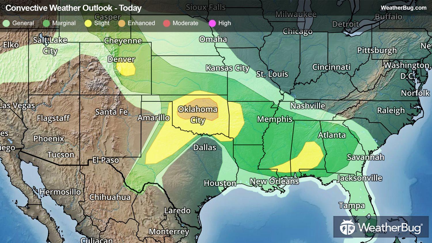
The long holiday weekend will feature plenty of severe thunderstorms from the Plains to the Southeast.
A stalled frontal boundary can be found stretching from the southern Rockies to the Southeast states and will remain in place through the holiday weekend. A series of upper-air weather disturbances moving near this front will help produce a scattering of strong to severe thunderstorms.
Tonight’s area of concern stretches across portions of central Colorado, northern and western Texas into Oklahoma, southern Kansas, Arkansas, northern Mississippi, and portions of Alabama and southern Mississippi. This is where the government’s Storm Prediction Center has issued multiple **_Slight Risks_**, or 2 out of 5 on the severe weather probability scale, for thunderstorms.
All modes of severe weather are expected tonight. This includes portions of Texas and Oklahoma, where very large hailstones and a few tornadoes will be possible. Here, an _**Enhanced Risk**_, a 3 out of 5, was opened over central Oklahoma.
Some cities at-risk for severe weather today include Lubbock and Wichita Falls, Texas, Denver, Oklahoma City, and Montgomery, Ala.
A **Severe Thunderstorm Watch** has expanded from central Colorado tonight into southern Kansas, northern Oklahoma and southwestern Missouri and northwestern Arkansas. This includes the cities of Eads, Colo., Wichita and Sedan, Kan., Tulsa, Okla., Fayetteville, Ark., and Joplin, Mo.
Severe thunderstorms will remain possible on Sunday from northern and western Texas into Oklahoma, Arkansas, southwestern Tennessee, northern Mississippi, and northern Alabama. Once again, all modes of severe weather will be possible on Sunday. Here, another pairing of **_Enhanced and Slight Risks_** have been issued for Sunday by the Storm Prediction Center, with the former designation focused over north-central Texas and southwestern Oklahoma.
A few severe thunderstorms will remain possible across Texas on Monday, while a few stronger storms will remain possible from Oklahoma to Georgia.
In addition to the severe thunderstorms, rounds of moderate to heavy rainfall will lead to flooding concerns across portions of southeastern Kansas into Missouri, northern Arkansas, and southern and central Oklahoma where **Flood Watches** are in effect for most of the holiday weekend. Localized rainfall totals of 3 to 5 inches will be possible. Remember, when you see a flooded roadway, “Turn around, don’t drown!”
Make sure to know the difference between a watch and a warning should they become issued. A “watch” means that conditions are favorable for severe weather to occur and to be on alert for any rapidly changing conditions. A “warning” means that severe weather is imminent, and you should act fast to remain safe.
The best way to remain safe is to stay prepared and informed about your local weather. Have a severe weather kit packed with a battery-operated radio, water, and non-perishable food items should you be without power for long periods of time. Also, check the WeatherBug app frequently for any updates on today's severe weather. Remember, "When Thunder Roars, Go Indoors!"
We use technologies, such as cookies, to analyze your use (i.e., pages visited), to customize content, for our internal analytics purposes and for security and other purposes. By continuing to use this website, you agree to this usage. Please review our [privacy policy](/legal/privacy) for more details as well as for information on how to contact us to object to these activities. [Ad Choices](/legal/privacy#digitaladvertisingandyourchoices)
```json
{"@context":"https://schema.org","@type":"NewsArticle","mainEntityOfPage":{"@type":"WebPage","@id":"https://www.weatherbug.com/news/Big-Thunderstorms-Target-S-Plains-to-the-Southeas"},"headline":"Big Thunderstorms Target S. Plains to the Southeast","description":"The holiday weekend will feature severe storms from the Plains to the Southeast. ","image":["https://cms-assets-con.cdn.weatherbug.net/assets/contentitems/ad/ad499d2c-b265-4d01-b031-d4ebd14523af/52e0ce98-d40a-4283-82d1-d0fe816ebf4b/be907c32-8d44-4f3d-978e-9680ab007b1f.jpg"],"datePublished":"2025-05-25T06:35:48Z","dateModified":"2025-05-25T06:35:48Z","dateCreated":"2025-05-25T06:35:48Z","articleSection":"Weather News","keywords":"flood,hail,map,maps,Plains,rain,severe,South,Southeast,storms,tornado,wind","articleBody":"The long holiday weekend will feature plenty of severe thunderstorms from the Plains to the Southeast.
\r\n
\r\nA stalled frontal boundary can be found stretching from the southern Rockies to the Southeast states and will remain in place through the holiday weekend. A series of upper-air weather disturbances moving near this front will help produce a scattering of strong to severe thunderstorms.
\r\n
\r\nTonight’s area of concern stretches across portions of central Colorado, northern and western Texas into Oklahoma, southern Kansas, Arkansas, northern Mississippi, and portions of Alabama and southern Mississippi. This is where the government’s Storm Prediction Center has issued multiple Slight Risks, or 2 out of 5 on the severe weather probability scale, for thunderstorms.
\r\n
\r\nAll modes of severe weather are expected tonight. This includes portions of Texas and Oklahoma, where very large hailstones and a few tornadoes will be possible. Here, an Enhanced Risk, a 3 out of 5, was opened over central Oklahoma.
\r\n
\r\nSome cities at-risk for severe weather today include Lubbock and Wichita Falls, Texas, Denver, Oklahoma City, and Montgomery, Ala.
\r\n
\r\nA Severe Thunderstorm Watch has expanded from central Colorado tonight into southern Kansas, northern Oklahoma and southwestern Missouri and northwestern Arkansas. This includes the cities of Eads, Colo., Wichita and Sedan, Kan., Tulsa, Okla., Fayetteville, Ark., and Joplin, Mo.
\r\n
\r\nSevere thunderstorms will remain possible on Sunday from northern and western Texas into Oklahoma, Arkansas, southwestern Tennessee, northern Mississippi, and northern Alabama. Once again, all modes of severe weather will be possible on Sunday. Here, another pairing of Enhanced and Slight Risks have been issued for Sunday by the Storm Prediction Center, with the former designation focused over north-central Texas and southwestern Oklahoma.
\r\n
\r\nA few severe thunderstorms will remain possible across Texas on Monday, while a few stronger storms will remain possible from Oklahoma to Georgia.
\r\n
\r\nIn addition to the severe thunderstorms, rounds of moderate to heavy rainfall will lead to flooding concerns across portions of southeastern Kansas into Missouri, northern Arkansas, and southern and central Oklahoma where Flood Watches are in effect for most of the holiday weekend. Localized rainfall totals of 3 to 5 inches will be possible. Remember, when you see a flooded roadway, “Turn around, don’t drown!”
\r\n
\r\nMake sure to know the difference between a watch and a warning should they become issued. A “watch” means that conditions are favorable for severe weather to occur and to be on alert for any rapidly changing conditions. A “warning” means that severe weather is imminent, and you should act fast to remain safe.
\r\n
\r\nThe best way to remain safe is to stay prepared and informed about your local weather. Have a severe weather kit packed with a battery-operated radio, water, and non-perishable food items should you be without power for long periods of time. Also, check the WeatherBug app frequently for any updates on today's severe weather. Remember, \"When Thunder Roars, Go Indoors!\"","author":{"@type":"Person","name":"By WeatherBug Meteorologist, Rob Miller","url":"https://www.weatherbug.com"},"publisher":{"@type":"Organization","name":"WeatherBug","logo":{"@type":"ImageObject","url":"https://www.weatherbug.com/images/sharing/f1ff28ba-6f06-4745-a782-011a20397e16.png"}}}
{"@context":"https://schema.org","@type":"WebSite","mainEntityOfPage":{"@type":"WebPage","@id":"https://www.weatherbug.com/news/Big-Thunderstorms-Target-S-Plains-to-the-Southeas","relatedLink":"https://www.weatherbug.com/news/Big-Thunderstorms-Target-S-Plains-to-the-Southeas"},"name":"WeatherBug","url":"https://www.weatherbug.com/news/Big-Thunderstorms-Target-S-Plains-to-the-Southeas","headline":"Big Thunderstorms Target S. Plains to the Southeast","description":"The holiday weekend will feature severe storms from the Plains to the Southeast. ","dateModified":"2025-05-25T06:35:48Z","publisher":{"@type":"Organization","name":"WeatherBug","url":"https://www.weatherbug.com","sameAs":["https://www.facebook.com/WeatherBug","https://instagram.com/WeatherBug","https://www.linkedin.com/company/weatherbug","https://www.pinterest.com/weatherbug","https://twitter.com/WeatherBug","https://www.youtube.com/user/WeatherBugVideo"],"logo":{"@type":"ImageObject","url":"https://www.weatherbug.com/images/logos/weatherbug_logo_620x447.png"}},"author":{"@type":"Organization","name":"WeatherBug","url":"https://www.weatherbug.com","sameAs":["https://www.facebook.com/WeatherBug","https://instagram.com/WeatherBug","https://www.linkedin.com/company/weatherbug","https://www.pinterest.com/weatherbug","https://twitter.com/WeatherBug","https://www.youtube.com/user/WeatherBugVideo"],"logo":{"@type":"ImageObject","url":"https://www.weatherbug.com/images/logos/weatherbug_logo_620x447.png"}}}
{"@context":"https://schema.org","@type":"Organization","name":"WeatherBug","logo":"https://www.weatherbug.com/images/logos/weatherbug_logo_620x447.png","url":"https://www.weatherbug.com","sameAs":["https://www.facebook.com/WeatherBug","https://instagram.com/WeatherBug","https://www.linkedin.com/company/weatherbug","https://www.pinterest.com/weatherbug","https://twitter.com/WeatherBug","https://www.youtube.com/user/WeatherBugVideo"]}
```