Back to forecast
Extremely Active 2024 Atlantic Hurricane Season Expected
May 15, 2024 at 01:26 PM EDT
By WeatherBug Meteorologists
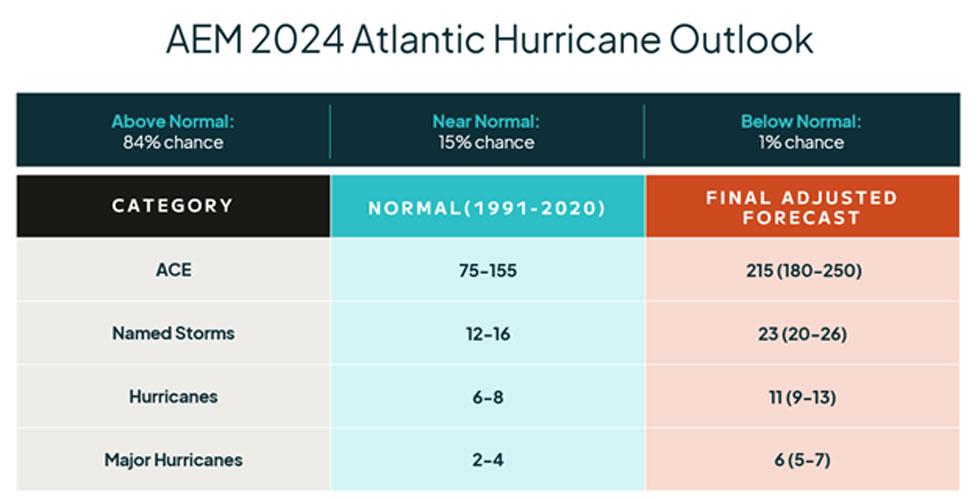
AEM released its 2024 Atlantic Hurricane Outlook which forecasts a well above normal hurricane season. The hurricane season runs from June 1 to November 30 and covers the Atlantic, Caribbean Sea, and the Gulf of Mexico.
Last year was the busiest Atlantic hurricane season on record in the presence of an El Niño weather pattern. The historical storm-dampening effects of El Niño were counteracted by extremely warm Atlantic Sea surface temperatures. The 2023 Atlantic hurricane season saw 20 named storms, which ranked fourth for the most-named storms in a year since 1950. Seven storms were hurricanes and three intensified to major hurricanes. Despite the active season, no names were retired. The last time the Atlantic had a season without any names retired was in 2014.
For 2024, the AEM Meteorology Team predicts 20 to 26 named storms to form, with nine to thirteen becoming hurricanes and five to seven of those hurricanes becoming major hurricanes with sustained winds of at least 111 mph. This is well above the long-term Atlantic season average.
“We are expecting the emergence of La Niña by this summer, which has been found to increase Atlantic hurricane activity by reducing vertical wind shear,” said Matt Mehallow, AEM Meteorologist. “Sea surface temperatures were incredibly warm during 2023, and the very warm ocean temperatures are expected to continue during the 2024 season, providing plenty of fuel for storms to take advantage of.”
The key factor this year will be the arrival of La Niña, a periodic development of cooler than normal water temperatures across the equatorial Pacific Ocean west of South America. This periodic change in the Pacific Ocean affects weather patterns throughout the Pacific Basin and contributes to decreased wind shear, or winds changing direction and intensity with altitude, in the Atlantic Hurricane Basin.
Wind shear makes it challenging for tropical systems to develop and the ones that develop often have difficulty growing. Lower wind shear normally allows tropical systems to become more organized and likely to form into tropical storms or hurricanes.
This year will showcase the powerful combination of the typical decrease in wind shear associated with La Niña and extremely warm Atlantic Ocean Sea surface temperatures. The addition of a strong West Africa Monsoon could enhance hurricane activity too, providing frequent, robust tropical waves moving into the Atlantic Main Development region. These factors all favor a very active hurricane season, so before hurricane season starts, make sure you and your family are prepared by planning ahead.
Remember, it only takes one hurricane to bring destructive winds and storm surge. If you live in an area that can be affected by a hurricane, now is the time to prepare for the season ahead by updating emergency plans, refreshing emergency kits and making sure flood and hurricane insurances are up to date.