---
title: On This Day in 1957: Andreanof Island Earthquake Causes Hawaii Tsunami | WeatherBug | WeatherBug
description: An 8.6 earthquake hits the southern Aleutian islands, causing a massive tsunami for parts of Hawaii.
canonical: https://www.weatherbug.com/news/On-This-Day-in-1957-Andreanof-Island-Earthquake-C
og:title: On This Day in 1957: Andreanof Island Earthquake Causes Hawaii Tsunami | WeatherBug | WeatherBug
og:description: An 8.6 earthquake hits the southern Aleutian islands, causing a massive tsunami for parts of Hawaii.
og:url: https://www.weatherbug.com/news/On-This-Day-in-1957-Andreanof-Island-Earthquake-C
og:site_name: WeatherBug
og:locale: en_US
og:image: https://cms-assets-con.cdn.weatherbug.net/assets/contentitems/93/931f90ce-3276-4a57-9feb-47ad1682ffe9/52e0ce98-d40a-4283-82d1-d0fe816ebf4b/d2ad711a-47a1-4e78-b948-5f77442dfa0c.jpg
og:image:width: 800
og:image:height: 600
og:image:alt: The location of the magnitude 8.6 earthquake epicenter and impact (earthquake.usgs.gov).
og:type: article
article:published_time: 2025-03-09T19:14:18Z
article:modified_time: 2025-03-09T19:14:18Z
article:author: By WeatherBug's Christopher Smith
article:tag: 1957
article:tag: damage
article:tag: earthquake
article:tag: Hawaii
article:tag: history
article:tag: March
article:tag: tsunami
twitter:card: summary_large_image
twitter:title: On This Day in 1957: Andreanof Island Earthquake Causes Hawaii Tsunami | WeatherBug
twitter:description: An 8.6 earthquake hits the southern Aleutian islands, causing a massive tsunami for parts of Hawaii.
twitter:image: https://cms-assets-con.cdn.weatherbug.net/assets/contentitems/93/931f90ce-3276-4a57-9feb-47ad1682ffe9/52e0ce98-d40a-4283-82d1-d0fe816ebf4b/d2ad711a-47a1-4e78-b948-5f77442dfa0c.jpg
---
[](/weather-forecast/now)
[Back to forecast](/weather-forecast/now)
# On This Day in 1957: Andreanof Island Earthquake Causes Hawaii Tsunami
March 9, 2025 at 03:14 PM EDT
By WeatherBug's Christopher Smith
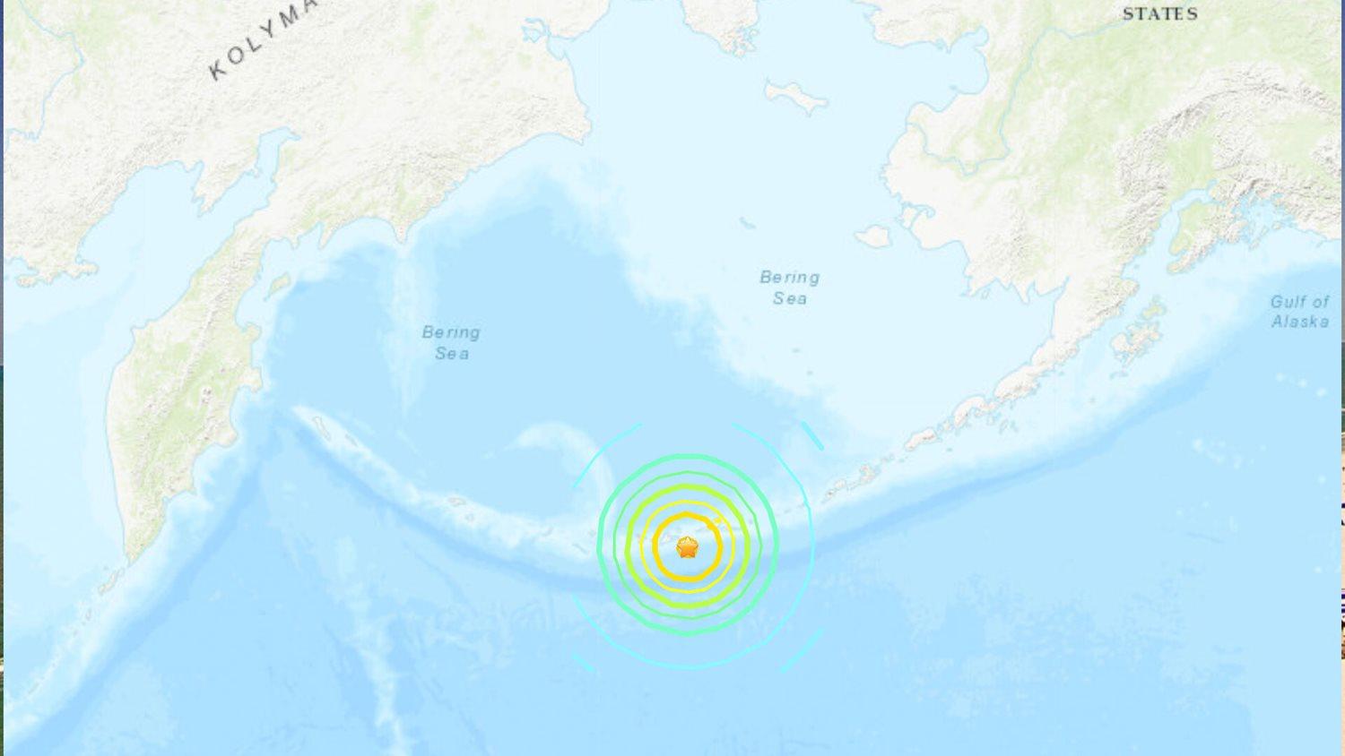
Alaska’s Aleutian Islands are located on what’s known as the “Ring of Fire,” a separation point where the Pacific plate of the Earth’s crust meets the surrounding continental plates. This delineation point fosters earthquakes and volcanic eruptions. Today marks the anniversary of one of those earthquakes that spawned a tsunami so large that it traveled more than 2,300 miles and devastated parts of Hawaii.
Early in the morning on March 9, 1957, a powerful magnitude 8.6 earthquake rattled Alaska’s southern Aleutian Islands. The earthquake’s impact immediately destroyed bridges and cracked roads. The earthquake was so violent that it triggered the eruption of Umnak Island’s Mount Vsevidof. This was the first time Mount Vsevidof had erupted in 200 years!
As if the earthquake’s damage wasn’t enough, a devastating tsunami followed. The tsunami first struck parts of Alaska with waves as high as 75 feet, which is equivalent to a wall of water about 6 stories high. The tsunami then traversed the Pacific Ocean and made it all the way to Hawaii.
Hawaii’s island of Kauai would be hit hardest by the tsunami. At Hāʻena State Park near Wainiha, Hawaii, waves as high as 38 feet were reported. Bridges and highways were submerged in water along Kaui’s northern shore. Other Hawaiian Islands were impacted by the tsunami, including the Big Island, where waves reaching 12 feet high damaged buildings in Hilo.
When all was set-and-done, Hawaii suffered the most damage as a result of the tsunami. The price tag was an estimated $46.5 million in today’s currency. Tsunami waves would even reach the U.S. West Coast, but with only minor damage reported in areas such as San Deigo Bay, Calif. It’s still not known today how many people perished in the tsunami.
_Sources:_ usgs.gov, washington.edu, sos.noaa.gov
\----------
_Story Image:_ The location of the magnitude 8.6 earthquake epicenter and impact (earthquake.usgs.gov).
We use technologies, such as cookies, to analyze your use (i.e., pages visited), to customize content, for our internal analytics purposes and for security and other purposes. By continuing to use this website, you agree to this usage. Please review our [privacy policy](/legal/privacy) for more details as well as for information on how to contact us to object to these activities. [Ad Choices](/legal/privacy#digitaladvertisingandyourchoices)
```json
{"@context":"https://schema.org","@type":"NewsArticle","mainEntityOfPage":{"@type":"WebPage","@id":"https://www.weatherbug.com/news/On-This-Day-in-1957-Andreanof-Island-Earthquake-C"},"headline":"On This Day in 1957: Andreanof Island Earthquake Causes Hawaii Tsunami","description":"An 8.6 earthquake hits the southern Aleutian islands, causing a massive tsunami for parts of Hawaii.","image":["https://cms-assets-con.cdn.weatherbug.net/assets/contentitems/93/931f90ce-3276-4a57-9feb-47ad1682ffe9/52e0ce98-d40a-4283-82d1-d0fe816ebf4b/d2ad711a-47a1-4e78-b948-5f77442dfa0c.jpg"],"datePublished":"2025-03-09T19:14:18Z","dateModified":"2025-03-09T19:14:18Z","dateCreated":"2025-03-09T19:14:18Z","articleSection":"Weather News","keywords":"1957,damage,earthquake,Hawaii,history,March,tsunami","articleBody":"Alaska’s Aleutian Islands are located on what’s known as the “Ring of Fire,” a separation point where the Pacific plate of the Earth’s crust meets the surrounding continental plates. This delineation point fosters earthquakes and volcanic eruptions. Today marks the anniversary of one of those earthquakes that spawned a tsunami so large that it traveled more than 2,300 miles and devastated parts of Hawaii.
\r\n
\r\nEarly in the morning on March 9, 1957, a powerful magnitude 8.6 earthquake rattled Alaska’s southern Aleutian Islands. The earthquake’s impact immediately destroyed bridges and cracked roads. The earthquake was so violent that it triggered the eruption of Umnak Island’s Mount Vsevidof. This was the first time Mount Vsevidof had erupted in 200 years!
\r\n
\r\nAs if the earthquake’s damage wasn’t enough, a devastating tsunami followed. The tsunami first struck parts of Alaska with waves as high as 75 feet, which is equivalent to a wall of water about 6 stories high. The tsunami then traversed the Pacific Ocean and made it all the way to Hawaii.
\r\n
\r\nHawaii’s island of Kauai would be hit hardest by the tsunami. At Hāʻena State Park near Wainiha, Hawaii, waves as high as 38 feet were reported. Bridges and highways were submerged in water along Kaui’s northern shore. Other Hawaiian Islands were impacted by the tsunami, including the Big Island, where waves reaching 12 feet high damaged buildings in Hilo.
\r\n
\r\nWhen all was set-and-done, Hawaii suffered the most damage as a result of the tsunami. The price tag was an estimated $46.5 million in today’s currency. Tsunami waves would even reach the U.S. West Coast, but with only minor damage reported in areas such as San Deigo Bay, Calif. It’s still not known today how many people perished in the tsunami.
\r\n
\r\nSources: usgs.gov, washington.edu, sos.noaa.gov
\r\n----------
\r\nStory Image: The location of the magnitude 8.6 earthquake epicenter and impact (earthquake.usgs.gov).","author":{"@type":"Person","name":"By WeatherBug's Christopher Smith","url":"https://www.weatherbug.com"},"publisher":{"@type":"Organization","name":"WeatherBug","logo":{"@type":"ImageObject","url":"https://www.weatherbug.com/images/sharing/f1ff28ba-6f06-4745-a782-011a20397e16.png"}}}
{"@context":"https://schema.org","@type":"WebSite","mainEntityOfPage":{"@type":"WebPage","@id":"https://www.weatherbug.com/news/On-This-Day-in-1957-Andreanof-Island-Earthquake-C","relatedLink":"https://www.weatherbug.com/news/On-This-Day-in-1957-Andreanof-Island-Earthquake-C"},"name":"WeatherBug","url":"https://www.weatherbug.com/news/On-This-Day-in-1957-Andreanof-Island-Earthquake-C","headline":"On This Day in 1957: Andreanof Island Earthquake Causes Hawaii Tsunami","description":"An 8.6 earthquake hits the southern Aleutian islands, causing a massive tsunami for parts of Hawaii.","dateModified":"2025-03-09T19:14:18Z","publisher":{"@type":"Organization","name":"WeatherBug","url":"https://www.weatherbug.com","sameAs":["https://www.facebook.com/WeatherBug","https://instagram.com/WeatherBug","https://www.linkedin.com/company/weatherbug","https://www.pinterest.com/weatherbug","https://twitter.com/WeatherBug","https://www.youtube.com/user/WeatherBugVideo"],"logo":{"@type":"ImageObject","url":"https://www.weatherbug.com/images/logos/weatherbug_logo_620x447.png"}},"author":{"@type":"Organization","name":"WeatherBug","url":"https://www.weatherbug.com","sameAs":["https://www.facebook.com/WeatherBug","https://instagram.com/WeatherBug","https://www.linkedin.com/company/weatherbug","https://www.pinterest.com/weatherbug","https://twitter.com/WeatherBug","https://www.youtube.com/user/WeatherBugVideo"],"logo":{"@type":"ImageObject","url":"https://www.weatherbug.com/images/logos/weatherbug_logo_620x447.png"}}}
{"@context":"https://schema.org","@type":"Organization","name":"WeatherBug","logo":"https://www.weatherbug.com/images/logos/weatherbug_logo_620x447.png","url":"https://www.weatherbug.com","sameAs":["https://www.facebook.com/WeatherBug","https://instagram.com/WeatherBug","https://www.linkedin.com/company/weatherbug","https://www.pinterest.com/weatherbug","https://twitter.com/WeatherBug","https://www.youtube.com/user/WeatherBugVideo"]}
```