---
title: Severe Storms Erupt Across Northern Plains | WeatherBug | WeatherBug
description: Another round of strong to severe thunderstorms will form across parts of the northern Plains this afternoon and tonight.
canonical: https://www.weatherbug.com/news/Severe%20Storms%20Erupt%20Across%20Northern%20Plains
og:title: Severe Storms Erupt Across Northern Plains | WeatherBug | WeatherBug
og:description: Another round of strong to severe thunderstorms will form across parts of the northern Plains this afternoon and tonight.
og:url: https://www.weatherbug.com/news/Severe%20Storms%20Erupt%20Across%20Northern%20Plains
og:site_name: WeatherBug
og:locale: en_US
og:image: https://cms-assets-con.cdn.weatherbug.net/assets/contentitems/12/12bdeee5-cf2f-4b7b-a4d0-bfd549278e02/52e0ce98-d40a-4283-82d1-d0fe816ebf4b/ddfdf6c1-53f6-4217-a746-df2c04ae8c05.jpg
og:image:width: 800
og:image:height: 600
og:image:alt: Today's Severe Weather Outlook
og:type: article
article:published_time: 2026-07-08T04:59:51Z
article:modified_time: 2026-07-08T04:59:51Z
article:author: By WeatherBug Meteorologist, Rob Richards
article:tag: July
article:tag: map
article:tag: maps
article:tag: rain
article:tag: thunderstorms
article:tag: severe
twitter:card: summary_large_image
twitter:title: Severe Storms Erupt Across Northern Plains | WeatherBug
twitter:description: Another round of strong to severe thunderstorms will form across parts of the northern Plains this afternoon and tonight.
twitter:image: https://cms-assets-con.cdn.weatherbug.net/assets/contentitems/12/12bdeee5-cf2f-4b7b-a4d0-bfd549278e02/52e0ce98-d40a-4283-82d1-d0fe816ebf4b/ddfdf6c1-53f6-4217-a746-df2c04ae8c05.jpg
---
[](/weather-forecast/now)
[Back to forecast](/weather-forecast/now)
# Severe Storms Erupt Across Northern Plains
July 8, 2026 at 12:59 AM EDT
By WeatherBug Meteorologist, Rob Richards
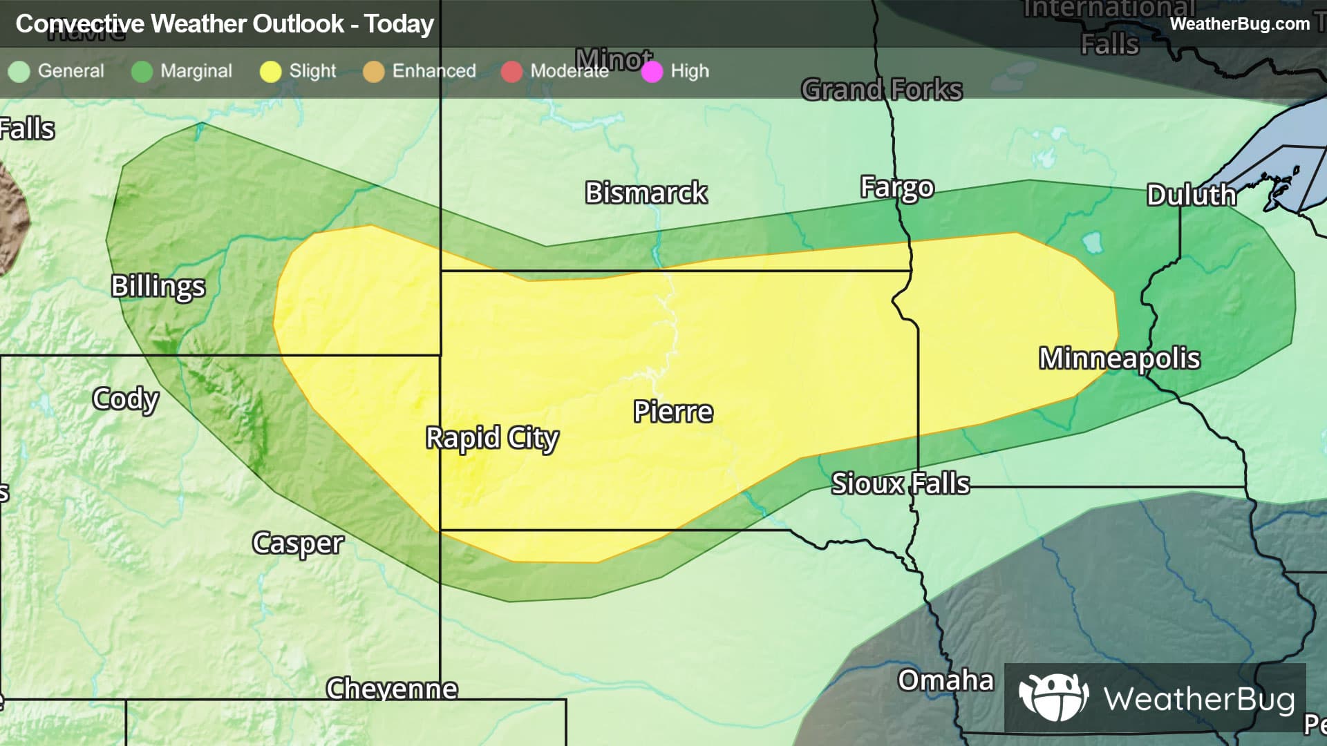
Another round of strong to severe thunderstorms will form across parts of the northern Plains this afternoon and tonight.
A vigorous disturbance will track across the Dakotas into Minnesota later today and tonight, bringing an area of showers and thunderstorms. Some of the thunderstorms will have the potential to be strong to severe in nature. Within thunderstorms, the main concerns will be heavy downpours, damaging wind gusts up to 60 to 70 mph, and large hail. There could even be a couple of brief, isolated tornadoes.
The government's Storm Prediction Center has issued a **_Slight Risk_** (level 2 of 5) for severe weather in parts of the north-central U.S. This covers southeastern Montana, northeastern Wyoming, far northwestern Nebraska, much of South Dakota, far southeastern North Dakota and parts of central Minnesota. Cities under this risk include Sheridan, Wyo., Rapid City and Aberdeen, S.D., and Brooklyn Park, Min.
**Severe Thunderstorm Watches** have been posted for both southwestern South Dakota and central Minnesota, including the cities of Rapid City, S.D., and Alexandria and St. Cloud, Minn.
As if dodging potent thunderstorms wasn’t enough, torrential downpours or repetitive rounds of moderate to heavy rain will be likely in both the north-central U.S. and from the Lower Mississippi Valley into the Mid-Atlantic. A quick 1 to 3 inches of rain could quickly fall, with locally higher amounts possible. These rainfall amounts in such a short time would likely lead to areas of flooding. If you do approach a flooded roadway, it is always best to “Turn Around, Don’t Drown!”
**Flood Watches** have been posted in eastern Montana. Additional **Flood Watches** stretch from southwestern Pennsylvania and western Maryland into central/eastern Virginia and northeastern North Carolina.
Make sure to know the difference between a watch and a warning should they be issued. A "watch" means that conditions are favorable for severe weather to occur, and to be on alert for any rapidly changing conditions. A "warning" means that severe weather is imminent, and you should act fast to remain safe.
The best way to remain safe is to stay prepared and informed about your local weather. Have a severe weather kit packed with a battery-operated radio, water, and non-perishable food items. Also, check the WeatherBug app frequently for any updates on today's severe weather. Remember, "When Thunder Roars, Go Indoors!"
We use technologies, such as cookies, to analyze your use (i.e., pages visited), to customize content, for our internal analytics purposes and for security and other purposes. By continuing to use this website, you agree to this usage. Please review our [privacy policy](/legal/privacy) for more details as well as for information on how to contact us to object to these activities. [Ad Choices](/legal/privacy#digitaladvertisingandyourchoices)
```json
{"@context":"https://schema.org","@type":"NewsArticle","mainEntityOfPage":{"@type":"WebPage","@id":"https://www.weatherbug.com/news/Severe Storms Erupt Across Northern Plains"},"headline":"Severe Storms Erupt Across Northern Plains","description":"Another round of strong to severe thunderstorms will form across parts of the northern Plains this afternoon and tonight. ","image":["https://cms-assets-con.cdn.weatherbug.net/assets/contentitems/12/12bdeee5-cf2f-4b7b-a4d0-bfd549278e02/52e0ce98-d40a-4283-82d1-d0fe816ebf4b/ddfdf6c1-53f6-4217-a746-df2c04ae8c05.jpg"],"datePublished":"2026-07-08T04:59:51Z","dateModified":"2026-07-08T04:59:51Z","dateCreated":"2026-07-07T06:31:39Z","articleSection":"Weather News","keywords":"July,map,maps,rain,thunderstorms,severe","articleBody":"Another round of strong to severe thunderstorms will form across parts of the northern Plains this afternoon and tonight.
A vigorous disturbance will track across the Dakotas into Minnesota later today and tonight, bringing an area of showers and thunderstorms. Some of the thunderstorms will have the potential to be strong to severe in nature. Within thunderstorms, the main concerns will be heavy downpours, damaging wind gusts up to 60 to 70 mph, and large hail. There could even be a couple of brief, isolated tornadoes.
The government's Storm Prediction Center has issued a Slight Risk (level 2 of 5) for severe weather in parts of the north-central U.S. This covers southeastern Montana, northeastern Wyoming, far northwestern Nebraska, much of South Dakota, far southeastern North Dakota and parts of central Minnesota. Cities under this risk include Sheridan, Wyo., Rapid City and Aberdeen, S.D., and Brooklyn Park, Min.
Severe Thunderstorm Watches have been posted for both southwestern South Dakota and central Minnesota, including the cities of Rapid City, S.D., and Alexandria and St. Cloud, Minn.
As if dodging potent thunderstorms wasn’t enough, torrential downpours or repetitive rounds of moderate to heavy rain will be likely in both the north-central U.S. and from the Lower Mississippi Valley into the Mid-Atlantic. A quick 1 to 3 inches of rain could quickly fall, with locally higher amounts possible. These rainfall amounts in such a short time would likely lead to areas of flooding. If you do approach a flooded roadway, it is always best to “Turn Around, Don’t Drown!”
Flood Watches have been posted in eastern Montana. Additional Flood Watches stretch from southwestern Pennsylvania and western Maryland into central/eastern Virginia and northeastern North Carolina.
Make sure to know the difference between a watch and a warning should they be issued. A \"watch\" means that conditions are favorable for severe weather to occur, and to be on alert for any rapidly changing conditions. A \"warning\" means that severe weather is imminent, and you should act fast to remain safe.
The best way to remain safe is to stay prepared and informed about your local weather. Have a severe weather kit packed with a battery-operated radio, water, and non-perishable food items. Also, check the WeatherBug app frequently for any updates on today's severe weather. Remember, \"When Thunder Roars, Go Indoors!\"
","author":{"@type":"Person","name":"By WeatherBug Meteorologist, Rob Richards","url":"https://www.weatherbug.com"},"publisher":{"@type":"Organization","name":"WeatherBug","logo":{"@type":"ImageObject","url":"https://www.weatherbug.com/images/sharing/f1ff28ba-6f06-4745-a782-011a20397e16.png"}}}
{"@context":"https://schema.org","@type":"WebSite","mainEntityOfPage":{"@type":"WebPage","@id":"https://www.weatherbug.com/news/Severe%20Storms%20Erupt%20Across%20Northern%20Plains","relatedLink":"https://www.weatherbug.com/news/Severe%20Storms%20Erupt%20Across%20Northern%20Plains"},"name":"WeatherBug","url":"https://www.weatherbug.com/news/Severe%20Storms%20Erupt%20Across%20Northern%20Plains","headline":"Severe Storms Erupt Across Northern Plains","description":"Another round of strong to severe thunderstorms will form across parts of the northern Plains this afternoon and tonight. ","dateModified":"2026-07-08T04:59:51Z","publisher":{"@type":"Organization","name":"WeatherBug","url":"https://www.weatherbug.com","sameAs":["https://www.facebook.com/WeatherBug","https://instagram.com/WeatherBug","https://www.linkedin.com/company/weatherbug","https://www.pinterest.com/weatherbug","https://twitter.com/WeatherBug","https://www.youtube.com/user/WeatherBugVideo"],"logo":{"@type":"ImageObject","url":"https://www.weatherbug.com/images/logos/weatherbug_logo_620x447.png"}},"author":{"@type":"Organization","name":"WeatherBug","url":"https://www.weatherbug.com","sameAs":["https://www.facebook.com/WeatherBug","https://instagram.com/WeatherBug","https://www.linkedin.com/company/weatherbug","https://www.pinterest.com/weatherbug","https://twitter.com/WeatherBug","https://www.youtube.com/user/WeatherBugVideo"],"logo":{"@type":"ImageObject","url":"https://www.weatherbug.com/images/logos/weatherbug_logo_620x447.png"}}}
{"@context":"https://schema.org","@type":"Organization","name":"WeatherBug","logo":"https://www.weatherbug.com/images/logos/weatherbug_logo_620x447.png","url":"https://www.weatherbug.com","sameAs":["https://www.facebook.com/WeatherBug","https://instagram.com/WeatherBug","https://www.linkedin.com/company/weatherbug","https://www.pinterest.com/weatherbug","https://twitter.com/WeatherBug","https://www.youtube.com/user/WeatherBugVideo"]}
```