---
title: Powerful Storms Rumble Across Eastern Seaboard | WeatherBug | WeatherBug
description: Dangerous weather will continue to rumble across many parts of the Eastern Seaboard through tonight.
canonical: https://www.weatherbug.com/news/Severe%20Storms%20To%20Strike%20The%20Northeast%20Down%20Into%20The%20Southeast
og:title: Powerful Storms Rumble Across Eastern Seaboard | WeatherBug | WeatherBug
og:description: Dangerous weather will continue to rumble across many parts of the Eastern Seaboard through tonight.
og:url: https://www.weatherbug.com/news/Severe%20Storms%20To%20Strike%20The%20Northeast%20Down%20Into%20The%20Southeast
og:site_name: WeatherBug
og:locale: en_US
og:image: https://cms-assets-con.cdn.weatherbug.net/assets/contentitems/b7/b753c279-65c3-4ca0-9589-aab7d38ec009/52e0ce98-d40a-4283-82d1-d0fe816ebf4b/38bab65a-d7c9-4e49-b55b-00f2a39242c5.jpg
og:image:width: 800
og:image:height: 600
og:image:alt: Tonight's Severe Weather Outlook
og:type: article
article:published_time: 2026-06-15T02:03:08Z
article:modified_time: 2026-06-15T02:03:08Z
article:author: Updated By WeatherBug Certified Digital Meteorologist, Fred Allen
article:tag: thunderstorms
article:tag: map
article:tag: maps
article:tag: severe
article:tag: Southeast
article:tag: Northeast
twitter:card: summary_large_image
twitter:title: Powerful Storms Rumble Across Eastern Seaboard | WeatherBug
twitter:description: Dangerous weather will continue to rumble across many parts of the Eastern Seaboard through tonight.
twitter:image: https://cms-assets-con.cdn.weatherbug.net/assets/contentitems/b7/b753c279-65c3-4ca0-9589-aab7d38ec009/52e0ce98-d40a-4283-82d1-d0fe816ebf4b/38bab65a-d7c9-4e49-b55b-00f2a39242c5.jpg
---
[](/weather-forecast/now)
[Back to forecast](/weather-forecast/now)
# Powerful Storms Rumble Across Eastern Seaboard
June 14, 2026 at 10:03 PM EDT
Updated By WeatherBug Certified Digital Meteorologist, Fred Allen
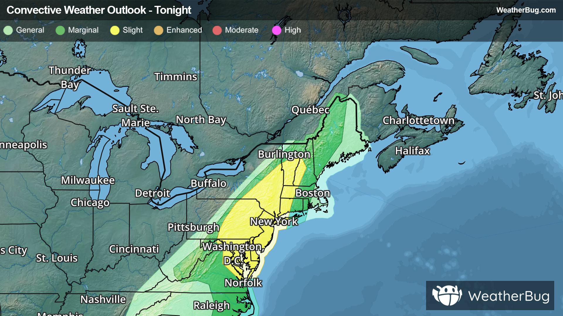
Powerful thunderstorms will pepper the Eastern Seaboard through early Monday morning. Damaging winds will be the primary risk, although a few tornadoes and hail will be possible too.
Dangerous weather will continue to precede a potent cold front dividing summer warmth and humidity from much cooler, drier air behind it. This activity will happen until predawn Monday, exiting the Mid-Atlantic and New England beaches last. Farther south, there may be a smattering of strong to severe thunderstorms through early tonight.
**Severe Thunderstorm Watches** stretch from parts of southern New York down into eastern Pennsylvania, New Jersey and the Delmarva region. Cities under the watches include Philadelphia and Wilmington, Del.
Scattered damaging wind gusts up to 70 mph, quarter size hail, and a few tornadoes will be possible within the most intense activity.
Flooding will be part of the thunderstorms makeup too. A quick 1 to 3 inches of rainfall will occur in a short time, with isolated totals of 4 to 5 inches possible. This could lead to urban and poor drainage flooding, and could promote river, stream, and creek flooding. **Flood Watches** remain in effect across northern and western Maine, northern New Hampshire, and northern Vermont. Remember, if you approach a road covered by water, it is best to “Turn Around, Don’t Drown!”
Make sure to know the difference between a watch and a warning should they be issued. A "watch" means that conditions are favorable for severe weather to occur, and to be on alert for any rapidly changing conditions. A "warning" means that severe weather is imminent, and you should act fast to remain safe.
The best way to remain safe is to stay prepared and informed about your local weather. Have a severe weather kit packed with a battery-operated radio, water, and non-perishable food items. Also, check the WeatherBug app frequently for any updates on today's severe weather. Remember, "When Thunder Roars, Go Indoors!"
We use technologies, such as cookies, to analyze your use (i.e., pages visited), to customize content, for our internal analytics purposes and for security and other purposes. By continuing to use this website, you agree to this usage. Please review our [privacy policy](/legal/privacy) for more details as well as for information on how to contact us to object to these activities. [Ad Choices](/legal/privacy#digitaladvertisingandyourchoices)
```json
{"@context":"https://schema.org","@type":"NewsArticle","mainEntityOfPage":{"@type":"WebPage","@id":"https://www.weatherbug.com/news/Severe Storms To Strike The Northeast Down Into The Southeast"},"headline":"Powerful Storms Rumble Across Eastern Seaboard","description":"Dangerous weather will continue to rumble across many parts of the Eastern Seaboard through tonight.","image":["https://cms-assets-con.cdn.weatherbug.net/assets/contentitems/b7/b753c279-65c3-4ca0-9589-aab7d38ec009/52e0ce98-d40a-4283-82d1-d0fe816ebf4b/38bab65a-d7c9-4e49-b55b-00f2a39242c5.jpg"],"datePublished":"2026-06-15T02:03:08Z","dateModified":"2026-06-15T02:03:08Z","dateCreated":"2026-06-14T06:41:12Z","articleSection":"Weather News","keywords":"thunderstorms,map,maps,severe,Southeast,Northeast","articleBody":"Powerful thunderstorms will pepper the Eastern Seaboard through early Monday morning. Damaging winds will be the primary risk, although a few tornadoes and hail will be possible too.
Dangerous weather will continue to precede a potent cold front dividing summer warmth and humidity from much cooler, drier air behind it. This activity will happen until predawn Monday, exiting the Mid-Atlantic and New England beaches last. Farther south, there may be a smattering of strong to severe thunderstorms through early tonight.
Severe Thunderstorm Watches stretch from parts of southern New York down into eastern Pennsylvania, New Jersey and the Delmarva region. Cities under the watches include Philadelphia and Wilmington, Del.
Scattered damaging wind gusts up to 70 mph, quarter size hail, and a few tornadoes will be possible within the most intense activity.
Flooding will be part of the thunderstorms makeup too. A quick 1 to 3 inches of rainfall will occur in a short time, with isolated totals of 4 to 5 inches possible. This could lead to urban and poor drainage flooding, and could promote river, stream, and creek flooding. Flood Watches remain in effect across northern and western Maine, northern New Hampshire, and northern Vermont. Remember, if you approach a road covered by water, it is best to “Turn Around, Don’t Drown!”
Make sure to know the difference between a watch and a warning should they be issued. A \"watch\" means that conditions are favorable for severe weather to occur, and to be on alert for any rapidly changing conditions. A \"warning\" means that severe weather is imminent, and you should act fast to remain safe.
The best way to remain safe is to stay prepared and informed about your local weather. Have a severe weather kit packed with a battery-operated radio, water, and non-perishable food items. Also, check the WeatherBug app frequently for any updates on today's severe weather. Remember, \"When Thunder Roars, Go Indoors!\"
","author":{"@type":"Person","name":"Updated By WeatherBug Certified Digital Meteorologist, Fred Allen","url":"https://www.weatherbug.com"},"publisher":{"@type":"Organization","name":"WeatherBug","logo":{"@type":"ImageObject","url":"https://www.weatherbug.com/images/sharing/f1ff28ba-6f06-4745-a782-011a20397e16.png"}}}
{"@context":"https://schema.org","@type":"WebSite","mainEntityOfPage":{"@type":"WebPage","@id":"https://www.weatherbug.com/news/Severe%20Storms%20To%20Strike%20The%20Northeast%20Down%20Into%20The%20Southeast","relatedLink":"https://www.weatherbug.com/news/Severe%20Storms%20To%20Strike%20The%20Northeast%20Down%20Into%20The%20Southeast"},"name":"WeatherBug","url":"https://www.weatherbug.com/news/Severe%20Storms%20To%20Strike%20The%20Northeast%20Down%20Into%20The%20Southeast","headline":"Powerful Storms Rumble Across Eastern Seaboard","description":"Dangerous weather will continue to rumble across many parts of the Eastern Seaboard through tonight.","dateModified":"2026-06-15T02:03:08Z","publisher":{"@type":"Organization","name":"WeatherBug","url":"https://www.weatherbug.com","sameAs":["https://www.facebook.com/WeatherBug","https://instagram.com/WeatherBug","https://www.linkedin.com/company/weatherbug","https://www.pinterest.com/weatherbug","https://twitter.com/WeatherBug","https://www.youtube.com/user/WeatherBugVideo"],"logo":{"@type":"ImageObject","url":"https://www.weatherbug.com/images/logos/weatherbug_logo_620x447.png"}},"author":{"@type":"Organization","name":"WeatherBug","url":"https://www.weatherbug.com","sameAs":["https://www.facebook.com/WeatherBug","https://instagram.com/WeatherBug","https://www.linkedin.com/company/weatherbug","https://www.pinterest.com/weatherbug","https://twitter.com/WeatherBug","https://www.youtube.com/user/WeatherBugVideo"],"logo":{"@type":"ImageObject","url":"https://www.weatherbug.com/images/logos/weatherbug_logo_620x447.png"}}}
{"@context":"https://schema.org","@type":"Organization","name":"WeatherBug","logo":"https://www.weatherbug.com/images/logos/weatherbug_logo_620x447.png","url":"https://www.weatherbug.com","sameAs":["https://www.facebook.com/WeatherBug","https://instagram.com/WeatherBug","https://www.linkedin.com/company/weatherbug","https://www.pinterest.com/weatherbug","https://twitter.com/WeatherBug","https://www.youtube.com/user/WeatherBugVideo"]}
```