---
title: Severe Thunderstorms Take Aim At Northern New England | WeatherBug | WeatherBug
description: Northern New England and adjacent New York state near Lake Champlain will see the potential for severe thunderstorms today.
canonical: https://www.weatherbug.com/news/Severe-Thunderstorms-Possible-Across-Northern-New-England
og:title: Severe Thunderstorms Take Aim At Northern New England | WeatherBug | WeatherBug
og:description: Northern New England and adjacent New York state near Lake Champlain will see the potential for severe thunderstorms today.
og:url: https://www.weatherbug.com/news/Severe-Thunderstorms-Possible-Across-Northern-New-England
og:site_name: WeatherBug
og:locale: en_US
og:image: https://cms-assets-con.cdn.weatherbug.net/assets/contentitems/f1/f12a0c94-6bf6-435d-9d11-3bff2082b522/52e0ce98-d40a-4283-82d1-d0fe816ebf4b/5f5f0a13-0f09-48e1-96fd-bf4c6d17a470.jpg
og:image:width: 800
og:image:height: 600
og:image:alt: Today's Severe Weather Outlook
og:type: article
article:published_time: 2026-07-15T01:20:51Z
article:modified_time: 2026-07-15T01:20:51Z
article:author: By WeatherBug Meteorologist, Mark Paquette
article:tag: map
article:tag: maps
article:tag: lightning
article:tag: thunder
article:tag: severe
article:tag: wind
article:tag: rain
article:tag: hail
twitter:card: summary_large_image
twitter:title: Severe Thunderstorms Take Aim At Northern New England | WeatherBug
twitter:description: Northern New England and adjacent New York state near Lake Champlain will see the potential for severe thunderstorms today.
twitter:image: https://cms-assets-con.cdn.weatherbug.net/assets/contentitems/f1/f12a0c94-6bf6-435d-9d11-3bff2082b522/52e0ce98-d40a-4283-82d1-d0fe816ebf4b/5f5f0a13-0f09-48e1-96fd-bf4c6d17a470.jpg
---
[](/weather-forecast/now)
[Back to forecast](/weather-forecast/now)
# Severe Thunderstorms Take Aim At Northern New England
July 14, 2026 at 09:20 PM EDT
By WeatherBug Meteorologist, Mark Paquette
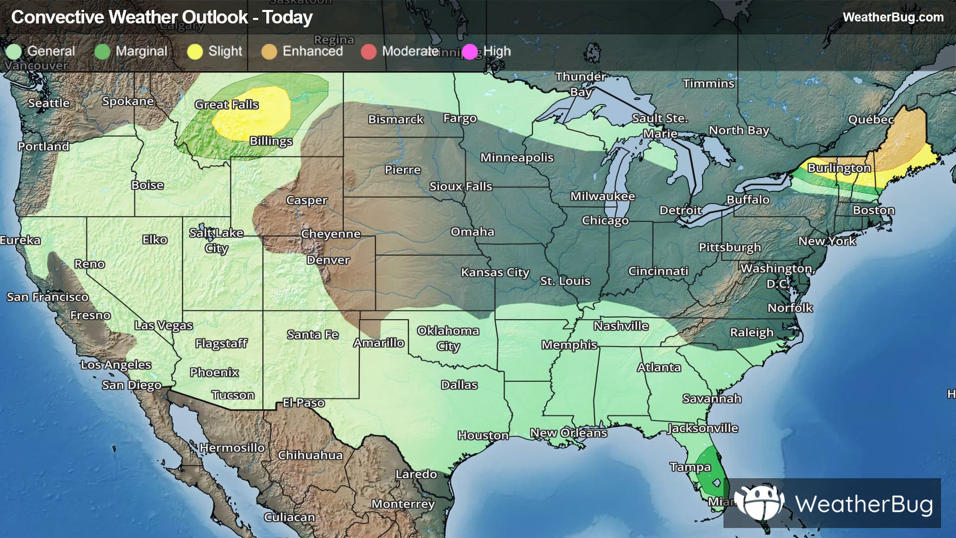
Northern New England and adjacent New York State near Lake Champlain will see the potential for severe thunderstorms today. Strong wind gusts, large hail, and even an isolated tornado are all possible in these thunderstorms.
These thunderstorms are what some people refer to as forming due to the "ring of fire". Much like how that term is used with plate tectonics, where earthquakes and volcanoes are commonly found along the boundaries of different tectonic plates, these thunderstorms are going to form along the meeting point of different air masses. A series of disturbances high in the atmosphere traveling along the edge of a building "heat dome" to the southwest and a cooler and drier air mass found over Quebec, Labrador, and the Canadian Maritime provinces will be the focal point of these thunderstorms.
The government’s Storm Prediction Center has issued an **_Enhanced Risk_**, a 3 out of 5 on the severe weather probability scale, for severe weather from extreme northeast New York, northern Vermont, northern New Hampshire and a wide swath of northern and central Maine. To the south of this area, a **_Slight Risk_**, a 2 out of 5 on the severe weather probability scale, is found for a narrow area of northern New York, central Vermont, central New Hampshire and much of southern and eastern Maine. Threats of damaging wind gusts, large hail, and even a tornado or two will be possible for cities including Burlington and Colchester, Vt., Plattsburgh, N.Y., and Lewiston, Augusta and Bangor in Maine.
There is an additional _**Slight Risk**_ area found in central Montana. Within the region, which includes Great Falls, Mont., there is also a threat of damaging winds and large hail.
A **Severe Thunderstorm Watch** has been posted for far northern New York to the northwestern neck of Maine, including Massena, N.Y., St, Johnsbury, N.H., and Burlington and Montpelier, Vt.
A separate Severe Thunderstorm Watch is also in effect for much of central and northeastern Montana, including Helena, Great Falls, Glasgow, and Lewiston.
Make sure to know the difference between a watch and a warning should they be issued. A "watch" means that conditions are favorable for severe weather to occur, and to be on alert for any rapidly changing conditions. A "warning" means that severe weather is imminent, and you should act fast to remain safe.
The best way to remain safe is to stay prepared and informed about your local weather. Have a severe weather kit packed with a battery-operated radio, water, and non-perishable food items. Also, check the WeatherBug app frequently for any updates on today's severe weather. Remember, "When Thunder Roars, Go Indoors!"
We use technologies, such as cookies, to analyze your use (i.e., pages visited), to customize content, for our internal analytics purposes and for security and other purposes. By continuing to use this website, you agree to this usage. Please review our [privacy policy](/legal/privacy) for more details as well as for information on how to contact us to object to these activities. [Ad Choices](/legal/privacy#digitaladvertisingandyourchoices)
```json
{"@context":"https://schema.org","@type":"NewsArticle","mainEntityOfPage":{"@type":"WebPage","@id":"https://www.weatherbug.com/news/Severe-Thunderstorms-Possible-Across-Northern-New-England"},"headline":"Severe Thunderstorms Take Aim At Northern New England","description":"Northern New England and adjacent New York state near Lake Champlain will see the potential for severe thunderstorms today.","image":["https://cms-assets-con.cdn.weatherbug.net/assets/contentitems/f1/f12a0c94-6bf6-435d-9d11-3bff2082b522/52e0ce98-d40a-4283-82d1-d0fe816ebf4b/5f5f0a13-0f09-48e1-96fd-bf4c6d17a470.jpg"],"datePublished":"2026-07-15T01:20:51Z","dateModified":"2026-07-15T01:20:51Z","dateCreated":"2026-07-14T08:23:58Z","articleSection":"Weather News","keywords":"map,maps,lightning,thunder,severe,wind,rain,hail","articleBody":"Northern New England and adjacent New York State near Lake Champlain will see the potential for severe thunderstorms today. Strong wind gusts, large hail, and even an isolated tornado are all possible in these thunderstorms.
These thunderstorms are what some people refer to as forming due to the \"ring of fire\". Much like how that term is used with plate tectonics, where earthquakes and volcanoes are commonly found along the boundaries of different tectonic plates, these thunderstorms are going to form along the meeting point of different air masses. A series of disturbances high in the atmosphere traveling along the edge of a building \"heat dome\" to the southwest and a cooler and drier air mass found over Quebec, Labrador, and the Canadian Maritime provinces will be the focal point of these thunderstorms.
The government’s Storm Prediction Center has issued an Enhanced Risk, a 3 out of 5 on the severe weather probability scale, for severe weather from extreme northeast New York, northern Vermont, northern New Hampshire and a wide swath of northern and central Maine. To the south of this area, a Slight Risk, a 2 out of 5 on the severe weather probability scale, is found for a narrow area of northern New York, central Vermont, central New Hampshire and much of southern and eastern Maine. Threats of damaging wind gusts, large hail, and even a tornado or two will be possible for cities including Burlington and Colchester, Vt., Plattsburgh, N.Y., and Lewiston, Augusta and Bangor in Maine.
There is an additional Slight Risk area found in central Montana. Within the region, which includes Great Falls, Mont., there is also a threat of damaging winds and large hail.
A Severe Thunderstorm Watch has been posted for far northern New York to the northwestern neck of Maine, including Massena, N.Y., St, Johnsbury, N.H., and Burlington and Montpelier, Vt.
A separate Severe Thunderstorm Watch is also in effect for much of central and northeastern Montana, including Helena, Great Falls, Glasgow, and Lewiston.
Make sure to know the difference between a watch and a warning should they be issued. A \"watch\" means that conditions are favorable for severe weather to occur, and to be on alert for any rapidly changing conditions. A \"warning\" means that severe weather is imminent, and you should act fast to remain safe.
The best way to remain safe is to stay prepared and informed about your local weather. Have a severe weather kit packed with a battery-operated radio, water, and non-perishable food items. Also, check the WeatherBug app frequently for any updates on today's severe weather. Remember, \"When Thunder Roars, Go Indoors!\"
","author":{"@type":"Person","name":"By WeatherBug Meteorologist, Mark Paquette","url":"https://www.weatherbug.com"},"publisher":{"@type":"Organization","name":"WeatherBug","logo":{"@type":"ImageObject","url":"https://www.weatherbug.com/images/sharing/f1ff28ba-6f06-4745-a782-011a20397e16.png"}}}
{"@context":"https://schema.org","@type":"WebSite","mainEntityOfPage":{"@type":"WebPage","@id":"https://www.weatherbug.com/news/Severe-Thunderstorms-Possible-Across-Northern-New-England","relatedLink":"https://www.weatherbug.com/news/Severe-Thunderstorms-Possible-Across-Northern-New-England"},"name":"WeatherBug","url":"https://www.weatherbug.com/news/Severe-Thunderstorms-Possible-Across-Northern-New-England","headline":"Severe Thunderstorms Take Aim At Northern New England","description":"Northern New England and adjacent New York state near Lake Champlain will see the potential for severe thunderstorms today.","dateModified":"2026-07-15T01:20:51Z","publisher":{"@type":"Organization","name":"WeatherBug","url":"https://www.weatherbug.com","sameAs":["https://www.facebook.com/WeatherBug","https://instagram.com/WeatherBug","https://www.linkedin.com/company/weatherbug","https://www.pinterest.com/weatherbug","https://twitter.com/WeatherBug","https://www.youtube.com/user/WeatherBugVideo"],"logo":{"@type":"ImageObject","url":"https://www.weatherbug.com/images/logos/weatherbug_logo_620x447.png"}},"author":{"@type":"Organization","name":"WeatherBug","url":"https://www.weatherbug.com","sameAs":["https://www.facebook.com/WeatherBug","https://instagram.com/WeatherBug","https://www.linkedin.com/company/weatherbug","https://www.pinterest.com/weatherbug","https://twitter.com/WeatherBug","https://www.youtube.com/user/WeatherBugVideo"],"logo":{"@type":"ImageObject","url":"https://www.weatherbug.com/images/logos/weatherbug_logo_620x447.png"}}}
{"@context":"https://schema.org","@type":"Organization","name":"WeatherBug","logo":"https://www.weatherbug.com/images/logos/weatherbug_logo_620x447.png","url":"https://www.weatherbug.com","sameAs":["https://www.facebook.com/WeatherBug","https://instagram.com/WeatherBug","https://www.linkedin.com/company/weatherbug","https://www.pinterest.com/weatherbug","https://twitter.com/WeatherBug","https://www.youtube.com/user/WeatherBugVideo"]}
```