---
title: Major Hurricane Isaias Nears Gulf Coast, Life-Threatening Storm Surge Expected | WeatherBug | WeatherBug
description: Category 3 Hurricane Isaias is approaching the northern Gulf Coast, with landfall expected this evening. Dangerous storm surge, destructive winds, flooding rainfall, and tornadoes are expected across portions of the Southeast.
canonical: https://www.weatherbug.com/news/Tracking%20Tropics%20October%202026%20Gulf%20Storm
og:title: Major Hurricane Isaias Nears Gulf Coast, Life-Threatening Storm Surge Expected | WeatherBug | WeatherBug
og:description: Category 3 Hurricane Isaias is approaching the northern Gulf Coast, with landfall expected this evening. Dangerous storm surge, destructive winds, flooding rainfall, and tornadoes are expected across portions of the Southeast.
og:url: https://www.weatherbug.com/news/Tracking%20Tropics%20October%202026%20Gulf%20Storm
og:site_name: WeatherBug
og:locale: en_US
og:image: https://cms-assets-con.cdn.weatherbug.net/assets/contentitems/83/83d2fb5e-ff89-43b7-8b8b-b6d84199510a/52e0ce98-d40a-4283-82d1-d0fe816ebf4b/95ae29e9-330b-4773-9476-7d5162769e8a.png
og:image:width: 800
og:image:height: 600
og:image:alt: Tropical Storm Isaias Track October morning update
og:type: article
article:published_time: 2026-10-09T17:20:24Z
article:modified_time: 2026-10-09T17:20:24Z
article:author: By WeatherBug Meteorologist, Brittney Gomez
article:tag: tropics
article:tag: hurricane
article:tag: tropical
article:tag: storm
article:tag: hurricane
article:tag: Gulf
article:tag: Lousiana
article:tag: Florida
article:tag: Alabama
twitter:card: summary_large_image
twitter:title: Major Hurricane Isaias Nears Gulf Coast, Life-Threatening Storm Surge Expected | WeatherBug
twitter:description: Category 3 Hurricane Isaias is approaching the northern Gulf Coast, with landfall expected this evening. Dangerous storm surge, destructive winds, flooding rainfall, and tornadoes are expected across portions of the Southeast.
twitter:image: https://cms-assets-con.cdn.weatherbug.net/assets/contentitems/83/83d2fb5e-ff89-43b7-8b8b-b6d84199510a/52e0ce98-d40a-4283-82d1-d0fe816ebf4b/95ae29e9-330b-4773-9476-7d5162769e8a.png
---
[](/weather-forecast/now)
[Back to forecast](/weather-forecast/now)
# Major Hurricane Isaias Nears Gulf Coast, Life-Threatening Storm Surge Expected
October 9, 2026 at 01:20 PM EDT
By WeatherBug Meteorologist, Brittney Gomez
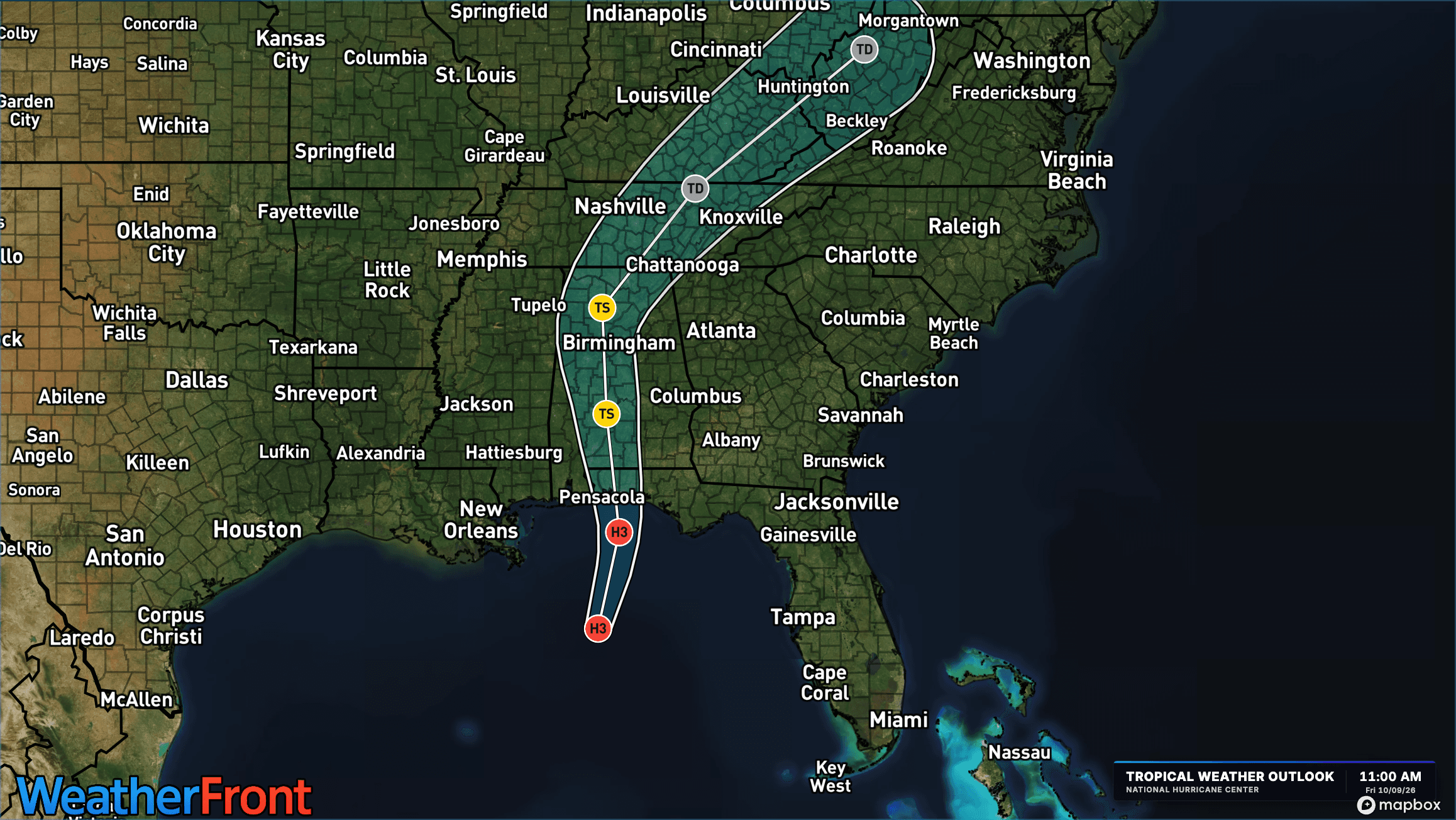
**Category 3 Hurricane Isaias is approaching the northern Gulf Coast, with landfall expected this evening. Dangerous storm surge, destructive winds, flooding rainfall, and tornadoes are expected across portions of the Southeast.**
Hurricane Isaias remains a powerful Category 3 hurricane as it approaches the northern Gulf Coast. According to the provided 10 a.m. CDT advisory, maximum sustained winds are near 120 mph, with higher gusts. The storm is moving north-northeast at 16 mph and is expected to make landfall within the hurricane warning area this evening.
Isaias could undergo some fluctuations in intensity before landfall but is expected to remain at or near major hurricane strength. Weakening is forecast after the storm moves inland tonight, with Isaias likely becoming post-tropical by late Saturday.
Hurricane-force winds extend up to 35 miles from the center, while tropical-storm-force winds reach as far as 205 miles outward.
**Follow the latest track, rainfall forecast and alerts for your location in the [WeatherBug app](https://apps.apple.com/us/app/weatherbug-weather-forecast/id281940292).**
## Hurricane Warnings and Storm Surge Alerts
A Hurricane Warning remains in effect from Ocean Springs, Mississippi, to the Bay/Gulf County line in Florida. Hurricane conditions are expected within the warning area this evening into early Saturday, with tropical storm conditions beginning in the next few hours.
A Storm Surge Warning extends from the mouth of the Mississippi River to the Suwannee River in Florida. A Storm Surge Watch is also in effect from the Suwannee River to Yankeetown, Florida.
Tropical Storm Warnings are in effect from the Jefferson/Plaquemines Parish line in Louisiana to west of Ocean Springs, Mississippi, and from east of the Bay/Gulf County line to the Aucilla River in Florida.
Residents in warning areas should rush preparations to completion and follow evacuation orders and instructions from local officials.
## Life-Threatening Storm Surge Could Reach 9 Feet
Storm surge remains one of the greatest threats from Isaias, with life-threatening coastal flooding expected along portions of the northern Gulf Coast.
**The highest storm surge, reaching 6 to 9 feet above ground level, is forecast from the Alabama/Florida border to Grayton Beach, Florida.**
Additional storm surge forecasts include:
* **4–7 feet:** Grayton Beach to Indian Pass, Florida
* **4–6 feet:** Indian Pass to Steinhatchee River, Florida, and Dauphin Island, Alabama, to the Alabama/Florida border
* **3–5 feet:** Steinhatchee River to Suwannee River, Florida; mouth of the Mississippi River to Dauphin Island, Alabama; and Lower Mobile Bay
* **2–4 feet:** Suwannee River to Yankeetown, Florida, and Upper Mobile Bay
The most significant flooding is expected along the immediate coastline, where dangerous waves could accompany rising water. Storm surge impacts will vary depending on the timing of high tide and local coastal conditions.
##
## Destructive Winds Expected to Spread Inland
Hurricane conditions are expected along portions of the northern Gulf Coast this evening and into early Saturday.
Hurricane-force winds could extend as far as 100 miles inland into southern Alabama, bringing the potential for widespread tree damage, power outages, and structural damage.
Tropical storm conditions are expected to begin across warning areas within the next few hours, making outdoor preparations increasingly dangerous as the day progresses.
## Up to 15 Inches of Rain Could Trigger Significant Flooding
Heavy rainfall from Isaias is expected to produce widespread flooding across portions of the Southeast through the weekend.
Southern Alabama, the Florida Panhandle and Big Bend, and southwestern Georgia could receive 4 to 8 inches of rain, with localized totals reaching 15 inches, especially where persistent rainbands develop.
Across the remainder of the Southeast, rainfall totals of 2 to 5 inches are expected, with isolated amounts up to 10 inches possible in the southern Appalachians and coastal Carolinas.
Flash flooding and urban flooding are possible, with considerable impacts likely across southern Alabama, the Florida Panhandle, and southwestern Georgia. River flooding is also expected, some of which could be significant.
## Tornado Threat Expands Across the Southeast
In addition to damaging winds and flooding, Isaias will bring an increasing tornado threat.
The risk of tornadoes will begin this afternoon and continue tonight across coastal Alabama, the Florida Panhandle, and southern Georgia.
By Saturday, the tornado threat will expand into portions of eastern Alabama, Georgia, and the Carolinas as the storm moves inland.
Tornadoes associated with tropical systems can develop quickly, making it important for residents to have multiple ways to receive weather warnings.
## Dangerous Surf and Rip Currents
Large swells generated by Isaias are spreading northward toward the Gulf Coast, creating dangerous surf and potentially life-threatening rip currents.
Beachgoers should stay out of the water in affected areas and follow guidance from local officials.
## What Happens Next?
Isaias is expected to continue moving north-northeast through this evening before turning northward on Saturday.
Landfall is forecast along the northern Gulf Coast this evening, with dangerous conditions developing well ahead of the storm's center.
Although Isaias is expected to weaken after landfall, heavy rainfall, flooding, gusty winds, and tornadoes will remain threats across parts of the Southeast into the weekend.
Residents along the Gulf Coast should complete storm preparations immediately, follow local evacuation instructions, and continue monitoring the latest forecasts and warnings through WeatherBug and the National Hurricane Center.
**IMPORTANT: This article will not be updated as frequently as new forecasts are issued. The National Hurricane Center issues updates every three hours. For the latest, most up-to-date forecast, visit the WeatherBug Hurricane Center: **
We use technologies, such as cookies, to analyze your use (i.e., pages visited), to customize content, for our internal analytics purposes and for security and other purposes. By continuing to use this website, you agree to this usage. Please review our [privacy policy](/legal/privacy) for more details as well as for information on how to contact us to object to these activities. [Ad Choices](/legal/privacy#digitaladvertisingandyourchoices)
```json
{"@context":"https://schema.org","@type":"NewsArticle","mainEntityOfPage":{"@type":"WebPage","@id":"https://www.weatherbug.com/news/Tracking Tropics October 2026 Gulf Storm"},"headline":"Major Hurricane Isaias Nears Gulf Coast, Life-Threatening Storm Surge Expected","description":"Category 3 Hurricane Isaias is approaching the northern Gulf Coast, with landfall expected this evening. Dangerous storm surge, destructive winds, flooding rainfall, and tornadoes are expected across portions of the Southeast.","image":["https://cms-assets-con.cdn.weatherbug.net/assets/contentitems/83/83d2fb5e-ff89-43b7-8b8b-b6d84199510a/52e0ce98-d40a-4283-82d1-d0fe816ebf4b/95ae29e9-330b-4773-9476-7d5162769e8a.png"],"datePublished":"2026-10-09T17:20:24Z","dateModified":"2026-10-09T17:20:24Z","dateCreated":"2026-10-06T18:13:19Z","articleSection":"Weather News","keywords":"tropics,hurricane,tropical,storm,hurricane,Gulf,Lousiana,Florida,Alabama","articleBody":"Category 3 Hurricane Isaias is approaching the northern Gulf Coast, with landfall expected this evening. Dangerous storm surge, destructive winds, flooding rainfall, and tornadoes are expected across portions of the Southeast.
Hurricane Isaias remains a powerful Category 3 hurricane as it approaches the northern Gulf Coast. According to the provided 10 a.m. CDT advisory, maximum sustained winds are near 120 mph, with higher gusts. The storm is moving north-northeast at 16 mph and is expected to make landfall within the hurricane warning area this evening.
Isaias could undergo some fluctuations in intensity before landfall but is expected to remain at or near major hurricane strength. Weakening is forecast after the storm moves inland tonight, with Isaias likely becoming post-tropical by late Saturday.
Hurricane-force winds extend up to 35 miles from the center, while tropical-storm-force winds reach as far as 205 miles outward.
Follow the latest track, rainfall forecast and alerts for your location in the WeatherBug app.
Hurricane Warnings and Storm Surge Alerts
A Hurricane Warning remains in effect from Ocean Springs, Mississippi, to the Bay/Gulf County line in Florida. Hurricane conditions are expected within the warning area this evening into early Saturday, with tropical storm conditions beginning in the next few hours.
A Storm Surge Warning extends from the mouth of the Mississippi River to the Suwannee River in Florida. A Storm Surge Watch is also in effect from the Suwannee River to Yankeetown, Florida.
Tropical Storm Warnings are in effect from the Jefferson/Plaquemines Parish line in Louisiana to west of Ocean Springs, Mississippi, and from east of the Bay/Gulf County line to the Aucilla River in Florida.
Residents in warning areas should rush preparations to completion and follow evacuation orders and instructions from local officials.
Life-Threatening Storm Surge Could Reach 9 Feet
Storm surge remains one of the greatest threats from Isaias, with life-threatening coastal flooding expected along portions of the northern Gulf Coast.
The highest storm surge, reaching 6 to 9 feet above ground level, is forecast from the Alabama/Florida border to Grayton Beach, Florida.
Additional storm surge forecasts include:
4–7 feet: Grayton Beach to Indian Pass, Florida
4–6 feet: Indian Pass to Steinhatchee River, Florida, and Dauphin Island, Alabama, to the Alabama/Florida border
3–5 feet: Steinhatchee River to Suwannee River, Florida; mouth of the Mississippi River to Dauphin Island, Alabama; and Lower Mobile Bay
2–4 feet: Suwannee River to Yankeetown, Florida, and Upper Mobile Bay
The most significant flooding is expected along the immediate coastline, where dangerous waves could accompany rising water. Storm surge impacts will vary depending on the timing of high tide and local coastal conditions.
Destructive Winds Expected to Spread Inland
Hurricane conditions are expected along portions of the northern Gulf Coast this evening and into early Saturday.
Hurricane-force winds could extend as far as 100 miles inland into southern Alabama, bringing the potential for widespread tree damage, power outages, and structural damage.
Tropical storm conditions are expected to begin across warning areas within the next few hours, making outdoor preparations increasingly dangerous as the day progresses.
Up to 15 Inches of Rain Could Trigger Significant Flooding
Heavy rainfall from Isaias is expected to produce widespread flooding across portions of the Southeast through the weekend.
Southern Alabama, the Florida Panhandle and Big Bend, and southwestern Georgia could receive 4 to 8 inches of rain, with localized totals reaching 15 inches, especially where persistent rainbands develop.
Across the remainder of the Southeast, rainfall totals of 2 to 5 inches are expected, with isolated amounts up to 10 inches possible in the southern Appalachians and coastal Carolinas.
Flash flooding and urban flooding are possible, with considerable impacts likely across southern Alabama, the Florida Panhandle, and southwestern Georgia. River flooding is also expected, some of which could be significant.
Tornado Threat Expands Across the Southeast
In addition to damaging winds and flooding, Isaias will bring an increasing tornado threat.
The risk of tornadoes will begin this afternoon and continue tonight across coastal Alabama, the Florida Panhandle, and southern Georgia.
By Saturday, the tornado threat will expand into portions of eastern Alabama, Georgia, and the Carolinas as the storm moves inland.
Tornadoes associated with tropical systems can develop quickly, making it important for residents to have multiple ways to receive weather warnings.
Dangerous Surf and Rip Currents
Large swells generated by Isaias are spreading northward toward the Gulf Coast, creating dangerous surf and potentially life-threatening rip currents.
Beachgoers should stay out of the water in affected areas and follow guidance from local officials.
What Happens Next?
Isaias is expected to continue moving north-northeast through this evening before turning northward on Saturday.
Landfall is forecast along the northern Gulf Coast this evening, with dangerous conditions developing well ahead of the storm's center.
Although Isaias is expected to weaken after landfall, heavy rainfall, flooding, gusty winds, and tornadoes will remain threats across parts of the Southeast into the weekend.
Residents along the Gulf Coast should complete storm preparations immediately, follow local evacuation instructions, and continue monitoring the latest forecasts and warnings through WeatherBug and the National Hurricane Center.
IMPORTANT: This article will not be updated as frequently as new forecasts are issued. The National Hurricane Center issues updates every three hours. For the latest, most up-to-date forecast, visit the WeatherBug Hurricane Center: https://www.weatherbug.com/hurricane/
","author":{"@type":"Person","name":"By WeatherBug Meteorologist, Brittney Gomez","url":"https://www.weatherbug.com"},"publisher":{"@type":"Organization","name":"WeatherBug","logo":{"@type":"ImageObject","url":"https://www.weatherbug.com/images/sharing/f1ff28ba-6f06-4745-a782-011a20397e16.png"}}}
{"@context":"https://schema.org","@type":"WebSite","mainEntityOfPage":{"@type":"WebPage","@id":"https://www.weatherbug.com/news/Tracking%20Tropics%20October%202026%20Gulf%20Storm","relatedLink":"https://www.weatherbug.com/news/Tracking%20Tropics%20October%202026%20Gulf%20Storm"},"name":"WeatherBug","url":"https://www.weatherbug.com/news/Tracking%20Tropics%20October%202026%20Gulf%20Storm","headline":"Major Hurricane Isaias Nears Gulf Coast, Life-Threatening Storm Surge Expected","description":"Category 3 Hurricane Isaias is approaching the northern Gulf Coast, with landfall expected this evening. Dangerous storm surge, destructive winds, flooding rainfall, and tornadoes are expected across portions of the Southeast.","dateModified":"2026-10-09T17:20:24Z","publisher":{"@type":"Organization","name":"WeatherBug","url":"https://www.weatherbug.com","sameAs":["https://www.facebook.com/WeatherBug","https://instagram.com/WeatherBug","https://www.linkedin.com/company/weatherbug","https://www.pinterest.com/weatherbug","https://twitter.com/WeatherBug","https://www.youtube.com/user/WeatherBugVideo"],"logo":{"@type":"ImageObject","url":"https://www.weatherbug.com/images/logos/weatherbug_logo_620x447.png"}},"author":{"@type":"Organization","name":"WeatherBug","url":"https://www.weatherbug.com","sameAs":["https://www.facebook.com/WeatherBug","https://instagram.com/WeatherBug","https://www.linkedin.com/company/weatherbug","https://www.pinterest.com/weatherbug","https://twitter.com/WeatherBug","https://www.youtube.com/user/WeatherBugVideo"],"logo":{"@type":"ImageObject","url":"https://www.weatherbug.com/images/logos/weatherbug_logo_620x447.png"}}}
{"@context":"https://schema.org","@type":"Organization","name":"WeatherBug","logo":"https://www.weatherbug.com/images/logos/weatherbug_logo_620x447.png","url":"https://www.weatherbug.com","sameAs":["https://www.facebook.com/WeatherBug","https://instagram.com/WeatherBug","https://www.linkedin.com/company/weatherbug","https://www.pinterest.com/weatherbug","https://twitter.com/WeatherBug","https://www.youtube.com/user/WeatherBugVideo"]}
```