---
title: Chantal Rapidly Weakening After Early Morning Landfall | WeatherBug | WeatherBug
description: Tropical Storm Chantal has made landfall in northeastern South Carolina this morning
canonical: https://www.weatherbug.com/news/Tropical-Depression-3-Forms-In-the-Atlantic
og:title: Chantal Rapidly Weakening After Early Morning Landfall | WeatherBug | WeatherBug
og:description: Tropical Storm Chantal has made landfall in northeastern South Carolina this morning
og:url: https://www.weatherbug.com/news/Tropical-Depression-3-Forms-In-the-Atlantic
og:site_name: WeatherBug
og:locale: en_US
og:image: https://cms-assets-con.cdn.weatherbug.net/assets/contentitems/79/79c2d967-9848-4bf5-bba9-657fdee34c44/52e0ce98-d40a-4283-82d1-d0fe816ebf4b/7677098b-52fe-4ae4-bff5-41b654973e97.jpg
og:image:width: 800
og:image:height: 600
og:image:alt: Tropical Storm Chantal Forecast Track
og:type: article
article:published_time: 2026-06-16T15:24:39Z
article:modified_time: 2026-06-16T15:24:39Z
article:author: UPDATED By WeatherBug Meteorologists
article:tag: map
article:tag: maps
article:tag: rain
article:tag: Southeast
article:tag: thunderstorms
article:tag: tropical
article:tag: wind
twitter:card: summary_large_image
twitter:title: Chantal Rapidly Weakening After Early Morning Landfall | WeatherBug
twitter:description: Tropical Storm Chantal has made landfall in northeastern South Carolina this morning
twitter:image: https://cms-assets-con.cdn.weatherbug.net/assets/contentitems/79/79c2d967-9848-4bf5-bba9-657fdee34c44/52e0ce98-d40a-4283-82d1-d0fe816ebf4b/7677098b-52fe-4ae4-bff5-41b654973e97.jpg
---
[](/weather-forecast/now)
[Back to forecast](/weather-forecast/now)
# Chantal Rapidly Weakening After Early Morning Landfall
June 16, 2026 at 11:24 AM EDT
UPDATED By WeatherBug Meteorologists
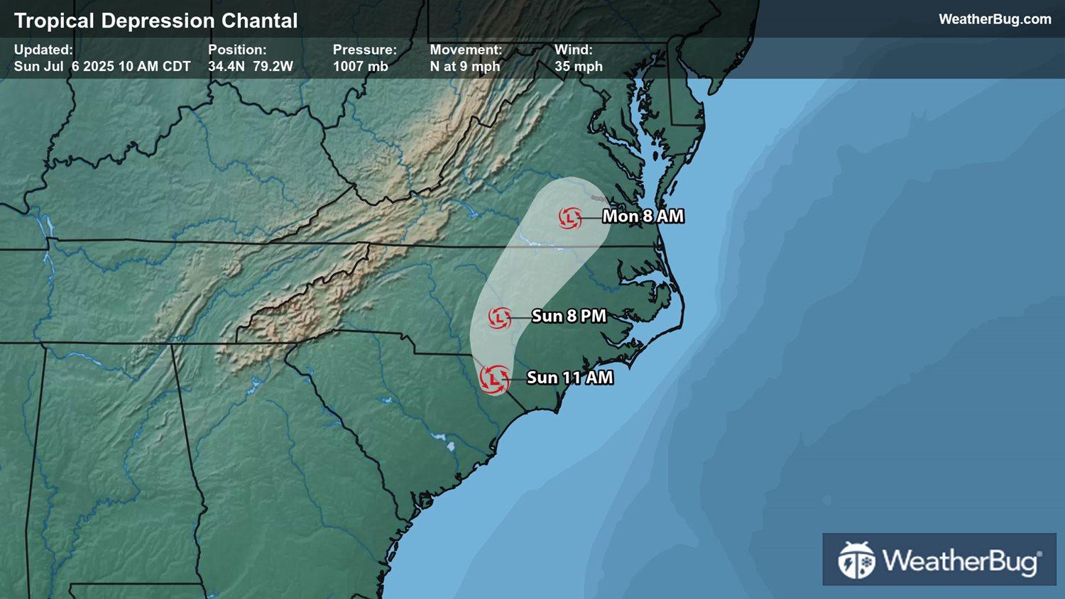
Tropical Storm Chantal made landfall near Huntington Beach in northeastern South Carolina this morning. Now a tropical depression, it will continue to weaken rapidly as it moves over the Carolinas.
As of 11 a.m. EDT, Tropical Depression Chantal was located near 34.4 N and 79.2 W, about 20 miles northwest of Lumberton, N.C., or 80 miles west of Wilmington, N.C. Chantal is packing top sustained winds of 35 mph and is moving north at 9 mph. It has a minimum central pressure of 1007 mb, or 29.74 inches of mercury.
Tropical Depression Chantal will track to north today and will eventually make a turn to the north-northeast tonight into early Monday morning. Chantal will continue to weaken over the next 24 hours, likely becoming a remnant low pressure system tonight. It would then dissipate completely by Monday afternoon.
Despite weakening, Chantal will bring heavy rainfall and gusty winds across parts of the Carolinas into the Mid-Atlantic. Rain amounts of 2 to 4 inches with locally 6 inches are possible near the coast. An elevated risk for flash flooding will continue into Monday. Some leftover rain could occur in eastern Virginia into southern Maryland and Delaware on Monday. Rain amounts will generally be less than an inch.
Wind gusts of 35 to 45 mph will occur along the South Carolina and southeastern North Carolina coasts. Isolated tornadoes and waterspouts cannot be ruled out throughout the day today. Life-threatening rip currents will be possible over portions of the East Coast from northeastern Florida to the Mid-Atlantic states today and Monday.
It is time to prepare for the hurricane season. Create a hurricane evacuation box now, before the storm, with bottled water, extra cell phone chargers, food and clothing. Scope out multiple different evacuation routes in case your preferred route is blocked or traffic jammed.
We use technologies, such as cookies, to analyze your use (i.e., pages visited), to customize content, for our internal analytics purposes and for security and other purposes. By continuing to use this website, you agree to this usage. Please review our [privacy policy](/legal/privacy) for more details as well as for information on how to contact us to object to these activities. [Ad Choices](/legal/privacy#digitaladvertisingandyourchoices)
```json
{"@context":"https://schema.org","@type":"NewsArticle","mainEntityOfPage":{"@type":"WebPage","@id":"https://www.weatherbug.com/news/Tropical-Depression-3-Forms-In-the-Atlantic"},"headline":"Chantal Rapidly Weakening After Early Morning Landfall","description":"Tropical Storm Chantal has made landfall in northeastern South Carolina this morning","image":["https://cms-assets-con.cdn.weatherbug.net/assets/contentitems/79/79c2d967-9848-4bf5-bba9-657fdee34c44/52e0ce98-d40a-4283-82d1-d0fe816ebf4b/7677098b-52fe-4ae4-bff5-41b654973e97.jpg"],"datePublished":"2026-06-16T15:24:39Z","dateModified":"2026-06-16T15:24:39Z","dateCreated":"2025-07-06T16:15:41Z","articleSection":"Weather News","keywords":"map,maps,rain,Southeast,thunderstorms,tropical,wind","articleBody":"Tropical Storm Chantal made landfall near Huntington Beach in northeastern South Carolina this morning. Now a tropical depression, it will continue to weaken rapidly as it moves over the Carolinas.
\r\n
\r\nAs of 11 a.m. EDT, Tropical Depression Chantal was located near 34.4 N and 79.2 W, about 20 miles northwest of Lumberton, N.C., or 80 miles west of Wilmington, N.C. Chantal is packing top sustained winds of 35 mph and is moving north at 9 mph. It has a minimum central pressure of 1007 mb, or 29.74 inches of mercury.
\r\n
\r\nTropical Depression Chantal will track to north today and will eventually make a turn to the north-northeast tonight into early Monday morning. Chantal will continue to weaken over the next 24 hours, likely becoming a remnant low pressure system tonight. It would then dissipate completely by Monday afternoon.
\r\n
\r\nDespite weakening, Chantal will bring heavy rainfall and gusty winds across parts of the Carolinas into the Mid-Atlantic. Rain amounts of 2 to 4 inches with locally 6 inches are possible near the coast. An elevated risk for flash flooding will continue into Monday. Some leftover rain could occur in eastern Virginia into southern Maryland and Delaware on Monday. Rain amounts will generally be less than an inch.
\r\n
\r\nWind gusts of 35 to 45 mph will occur along the South Carolina and southeastern North Carolina coasts. Isolated tornadoes and waterspouts cannot be ruled out throughout the day today. Life-threatening rip currents will be possible over portions of the East Coast from northeastern Florida to the Mid-Atlantic states today and Monday.
\r\n
\r\nIt is time to prepare for the hurricane season. Create a hurricane evacuation box now, before the storm, with bottled water, extra cell phone chargers, food and clothing. Scope out multiple different evacuation routes in case your preferred route is blocked or traffic jammed.","author":{"@type":"Person","name":"UPDATED By WeatherBug Meteorologists","url":"https://www.weatherbug.com"},"publisher":{"@type":"Organization","name":"WeatherBug","logo":{"@type":"ImageObject","url":"https://www.weatherbug.com/images/sharing/f1ff28ba-6f06-4745-a782-011a20397e16.png"}}}
{"@context":"https://schema.org","@type":"WebSite","mainEntityOfPage":{"@type":"WebPage","@id":"https://www.weatherbug.com/news/Tropical-Depression-3-Forms-In-the-Atlantic","relatedLink":"https://www.weatherbug.com/news/Tropical-Depression-3-Forms-In-the-Atlantic"},"name":"WeatherBug","url":"https://www.weatherbug.com/news/Tropical-Depression-3-Forms-In-the-Atlantic","headline":"Chantal Rapidly Weakening After Early Morning Landfall","description":"Tropical Storm Chantal has made landfall in northeastern South Carolina this morning","dateModified":"2026-06-16T15:24:39Z","publisher":{"@type":"Organization","name":"WeatherBug","url":"https://www.weatherbug.com","sameAs":["https://www.facebook.com/WeatherBug","https://instagram.com/WeatherBug","https://www.linkedin.com/company/weatherbug","https://www.pinterest.com/weatherbug","https://twitter.com/WeatherBug","https://www.youtube.com/user/WeatherBugVideo"],"logo":{"@type":"ImageObject","url":"https://www.weatherbug.com/images/logos/weatherbug_logo_620x447.png"}},"author":{"@type":"Organization","name":"WeatherBug","url":"https://www.weatherbug.com","sameAs":["https://www.facebook.com/WeatherBug","https://instagram.com/WeatherBug","https://www.linkedin.com/company/weatherbug","https://www.pinterest.com/weatherbug","https://twitter.com/WeatherBug","https://www.youtube.com/user/WeatherBugVideo"],"logo":{"@type":"ImageObject","url":"https://www.weatherbug.com/images/logos/weatherbug_logo_620x447.png"}}}
{"@context":"https://schema.org","@type":"Organization","name":"WeatherBug","logo":"https://www.weatherbug.com/images/logos/weatherbug_logo_620x447.png","url":"https://www.weatherbug.com","sameAs":["https://www.facebook.com/WeatherBug","https://instagram.com/WeatherBug","https://www.linkedin.com/company/weatherbug","https://www.pinterest.com/weatherbug","https://twitter.com/WeatherBug","https://www.youtube.com/user/WeatherBugVideo"]}
```