---
title: Tropical Development Nearly Certain in Gulf This Week | WeatherBug | WeatherBug
description: Tropical development in the Gulf is now looking increasingly likely, and residents along the northern Gulf Coast should be paying close attention over the next several days.
canonical: https://www.weatherbug.com/news/Tropical-Development-Likely-in-Gulf-This-Week
og:title: Tropical Development Nearly Certain in Gulf This Week | WeatherBug | WeatherBug
og:description: Tropical development in the Gulf is now looking increasingly likely, and residents along the northern Gulf Coast should be paying close attention over the next several days.
og:url: https://www.weatherbug.com/news/Tropical-Development-Likely-in-Gulf-This-Week
og:site_name: WeatherBug
og:locale: en_US
og:image: https://cms-assets-con.cdn.weatherbug.net/assets/contentitems/c2/c26ebd5f-d0b8-431d-88ec-9983630fd7c8/52e0ce98-d40a-4283-82d1-d0fe816ebf4b/4acb8e2e-2ca7-4b4b-9f85-b89ee1e89fec.png
og:image:width: 800
og:image:height: 600
og:image:alt: Probability of development from the National Hurricane Center. Update: Tuesday, October 6, 2026 2pm ET
og:type: article
article:published_time: 2026-10-06T18:13:19Z
article:modified_time: 2026-10-06T18:13:19Z
article:author: By WeatherBug Meteorologist, Brittney Gomez
article:tag: tropics
article:tag: hurricane
article:tag: tropical
article:tag: storm
article:tag: hurricane
article:tag: Gulf
article:tag: Lousiana
article:tag: Florida
article:tag: Alabama
twitter:card: summary_large_image
twitter:title: Tropical Development Nearly Certain in Gulf This Week | WeatherBug
twitter:description: Tropical development in the Gulf is now looking increasingly likely, and residents along the northern Gulf Coast should be paying close attention over the next several days.
twitter:image: https://cms-assets-con.cdn.weatherbug.net/assets/contentitems/c2/c26ebd5f-d0b8-431d-88ec-9983630fd7c8/52e0ce98-d40a-4283-82d1-d0fe816ebf4b/4acb8e2e-2ca7-4b4b-9f85-b89ee1e89fec.png
---
[](/weather-forecast/now)
[Missing translation for key: backTo forecast](/weather-forecast/now)
# Tropical Development Nearly Certain in Gulf This Week
October 6, 2026 at 02:13 PM EDT
By WeatherBug Meteorologist, Brittney Gomez
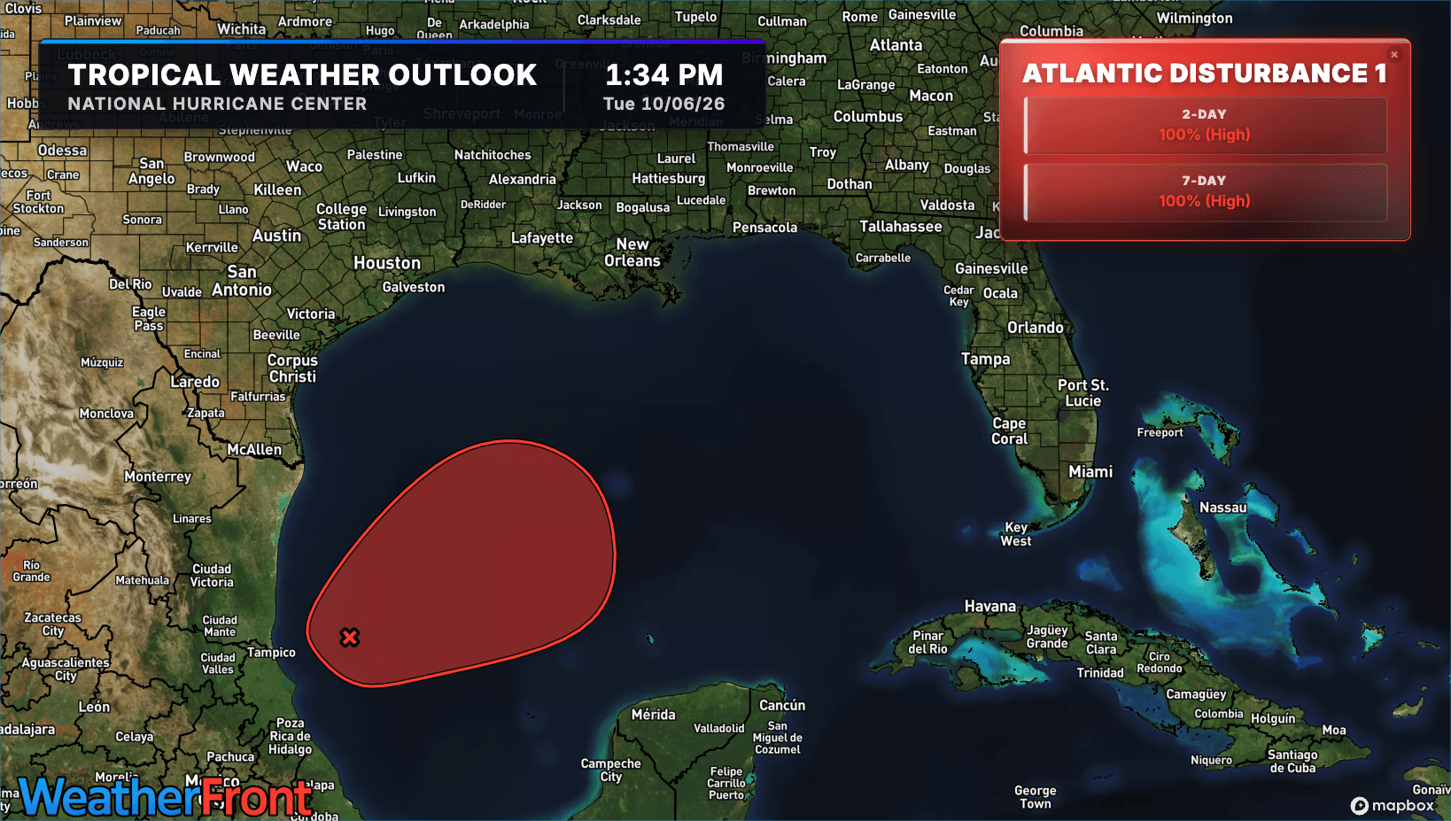
Tropical development in the Gulf is now looking likely, and residents along the northern Gulf Coast should be paying close attention over the next several days.
As of **2 p.m. EDT Tuesday**, the National Hurricane Center increased the chance of tropical development to **near 100% within both the next 48 hours and seven days.**
Satellite imagery and surface observations show that showers and thunderstorms associated with **Invest AL92** are becoming better organized while surface pressures continue to fall.
If those trends continue, the National Hurricane Center says **advisories will likely be initiated later Tuesday or Tuesday night.**
## Where Is the System Headed?
The disturbance is expected to move slowly eastward before turning **north or northeast toward the northern Gulf Coast by the end of the week.**
For now, anyone from the **Florida Panhandle to Louisiana** should closely monitor the system.
Exactly where it ultimately tracks remains uncertain. Because the system is still developing, it is too early to determine which areas of the northern Gulf Coast could experience the greatest impacts.
That's something that should become clearer as the circulation becomes better organized and forecasters get additional data.
##
## How Strong Could It Get?
Intensity remains one of the biggest questions.
Some forecast guidance has suggested the system could strengthen considerably over the Gulf, while other guidance has favored a weaker system.
There are also environmental factors that could eventually work against the storm. Increasing wind shear closer to the northern Gulf Coast could disrupt its circulation and potentially cause weakening before landfall.
However, **don't focus only on how strong the storm becomes.**
Even a system that weakens before reaching the coast could still bring hazards such as **heavy rain, flooding, tornadoes, strong winds and storm surge**, depending on its eventual track, size and strength.
## Better Forecast Data Is Coming
Forecasters should soon get a much better look at what's happening inside and around the developing system.
A **NOAA Gulfstream jet is scheduled to sample the environment over the Gulf Tuesday afternoon**, while Air Force and NOAA reconnaissance aircraft are scheduled to investigate the system on Wednesday.
Those observations can give forecast models and meteorologists more detailed information about the atmosphere surrounding the system and, once a circulation develops, what's happening inside it.
That should help improve forecasts of both its **track and intensity**.
## Why Isn't There a Forecast Cone Yet?
Despite development now looking nearly certain, there is still **no official forecast cone**.
That's because Invest AL92 has not yet been designated a tropical cyclone or Potential Tropical Cyclone.
The National Hurricane Center says that could change quickly, with **advisories likely later Tuesday or Tuesday night if current organization trends continue.**
Once advisories begin, we'll have an official NHC forecast to follow rather than relying primarily on individual model projections.
##
## What Should You Do Now?
If you live anywhere from **Louisiana to the Florida Panhandle**, this is the time to prepare, not panic.
Make sure weather alerts are turned on, review your hurricane plan, charge portable batteries, check flashlights and know whether your home is in a flood- or storm-surge-prone area.
You don't need to make decisions based on one model run. Instead, **follow official forecasts and be ready to act if watches or warnings are issued for your area.**
And remember: don't wait for a hurricane category to decide whether a storm matters to you. Water hazards like heavy rain, flooding and storm surge can be dangerous even if a tropical system weakens before reaching land.
We use technologies, such as cookies, to analyze your use (i.e., pages visited), to customize content, for our internal analytics purposes and for security and other purposes. By continuing to use this website, you agree to this usage. Please review our [privacy policy](/legal/privacy) for more details as well as for information on how to contact us to object to these activities. [Ad Choices](/legal/privacy#digitaladvertisingandyourchoices)
```json
{"@context":"https://schema.org","@type":"NewsArticle","mainEntityOfPage":{"@type":"WebPage","@id":"https://www.weatherbug.com/news/Tropical-Development-Likely-in-Gulf-This-Week"},"headline":"Tropical Development Nearly Certain in Gulf This Week","description":"Tropical development in the Gulf is now looking increasingly likely, and residents along the northern Gulf Coast should be paying close attention over the next several days.","image":["https://cms-assets-con.cdn.weatherbug.net/assets/contentitems/c2/c26ebd5f-d0b8-431d-88ec-9983630fd7c8/52e0ce98-d40a-4283-82d1-d0fe816ebf4b/4acb8e2e-2ca7-4b4b-9f85-b89ee1e89fec.png"],"datePublished":"2026-10-06T18:13:19Z","dateModified":"2026-10-06T18:13:19Z","dateCreated":"2026-10-06T18:13:19Z","articleSection":"Weather News","keywords":"tropics,hurricane,tropical,storm,hurricane,Gulf,Lousiana,Florida,Alabama","articleBody":"Tropical development in the Gulf is now looking likely, and residents along the northern Gulf Coast should be paying close attention over the next several days.
As of 2 p.m. EDT Tuesday, the National Hurricane Center increased the chance of tropical development to near 100% within both the next 48 hours and seven days.
Satellite imagery and surface observations show that showers and thunderstorms associated with Invest AL92 are becoming better organized while surface pressures continue to fall.
If those trends continue, the National Hurricane Center says advisories will likely be initiated later Tuesday or Tuesday night.
Where Is the System Headed?
The disturbance is expected to move slowly eastward before turning north or northeast toward the northern Gulf Coast by the end of the week.
For now, anyone from the Florida Panhandle to Louisiana should closely monitor the system.
Exactly where it ultimately tracks remains uncertain. Because the system is still developing, it is too early to determine which areas of the northern Gulf Coast could experience the greatest impacts.
That's something that should become clearer as the circulation becomes better organized and forecasters get additional data.
How Strong Could It Get?
Intensity remains one of the biggest questions.
Some forecast guidance has suggested the system could strengthen considerably over the Gulf, while other guidance has favored a weaker system.
There are also environmental factors that could eventually work against the storm. Increasing wind shear closer to the northern Gulf Coast could disrupt its circulation and potentially cause weakening before landfall.
However, don't focus only on how strong the storm becomes.
Even a system that weakens before reaching the coast could still bring hazards such as heavy rain, flooding, tornadoes, strong winds and storm surge, depending on its eventual track, size and strength.
Better Forecast Data Is Coming
Forecasters should soon get a much better look at what's happening inside and around the developing system.
A NOAA Gulfstream jet is scheduled to sample the environment over the Gulf Tuesday afternoon, while Air Force and NOAA reconnaissance aircraft are scheduled to investigate the system on Wednesday.
Those observations can give forecast models and meteorologists more detailed information about the atmosphere surrounding the system and, once a circulation develops, what's happening inside it.
That should help improve forecasts of both its track and intensity.
Why Isn't There a Forecast Cone Yet?
Despite development now looking nearly certain, there is still no official forecast cone.
That's because Invest AL92 has not yet been designated a tropical cyclone or Potential Tropical Cyclone.
The National Hurricane Center says that could change quickly, with advisories likely later Tuesday or Tuesday night if current organization trends continue.
Once advisories begin, we'll have an official NHC forecast to follow rather than relying primarily on individual model projections.
What Should You Do Now?
If you live anywhere from Louisiana to the Florida Panhandle, this is the time to prepare, not panic.
Make sure weather alerts are turned on, review your hurricane plan, charge portable batteries, check flashlights and know whether your home is in a flood- or storm-surge-prone area.
You don't need to make decisions based on one model run. Instead, follow official forecasts and be ready to act if watches or warnings are issued for your area.
And remember: don't wait for a hurricane category to decide whether a storm matters to you. Water hazards like heavy rain, flooding and storm surge can be dangerous even if a tropical system weakens before reaching land.
","author":{"@type":"Person","name":"By WeatherBug Meteorologist, Brittney Gomez","url":"https://www.weatherbug.com"},"publisher":{"@type":"Organization","name":"WeatherBug","logo":{"@type":"ImageObject","url":"https://www.weatherbug.com/images/sharing/f1ff28ba-6f06-4745-a782-011a20397e16.png"}}}
{"@context":"https://schema.org","@type":"WebSite","mainEntityOfPage":{"@type":"WebPage","@id":"https://www.weatherbug.com/news/Tropical-Development-Likely-in-Gulf-This-Week","relatedLink":"https://www.weatherbug.com/news/Tropical-Development-Likely-in-Gulf-This-Week"},"name":"WeatherBug","url":"https://www.weatherbug.com/news/Tropical-Development-Likely-in-Gulf-This-Week","headline":"Tropical Development Nearly Certain in Gulf This Week","description":"Tropical development in the Gulf is now looking increasingly likely, and residents along the northern Gulf Coast should be paying close attention over the next several days.","dateModified":"2026-10-06T18:13:19Z","publisher":{"@type":"Organization","name":"WeatherBug","url":"https://www.weatherbug.com","sameAs":["https://www.facebook.com/WeatherBug","https://instagram.com/WeatherBug","https://www.linkedin.com/company/weatherbug","https://www.pinterest.com/weatherbug","https://twitter.com/WeatherBug","https://www.youtube.com/user/WeatherBugVideo"],"logo":{"@type":"ImageObject","url":"https://www.weatherbug.com/images/logos/weatherbug_logo_620x447.png"}},"author":{"@type":"Organization","name":"WeatherBug","url":"https://www.weatherbug.com","sameAs":["https://www.facebook.com/WeatherBug","https://instagram.com/WeatherBug","https://www.linkedin.com/company/weatherbug","https://www.pinterest.com/weatherbug","https://twitter.com/WeatherBug","https://www.youtube.com/user/WeatherBugVideo"],"logo":{"@type":"ImageObject","url":"https://www.weatherbug.com/images/logos/weatherbug_logo_620x447.png"}}}
{"@context":"https://schema.org","@type":"Organization","name":"WeatherBug","logo":"https://www.weatherbug.com/images/logos/weatherbug_logo_620x447.png","url":"https://www.weatherbug.com","sameAs":["https://www.facebook.com/WeatherBug","https://instagram.com/WeatherBug","https://www.linkedin.com/company/weatherbug","https://www.pinterest.com/weatherbug","https://twitter.com/WeatherBug","https://www.youtube.com/user/WeatherBugVideo"]}
```