---
title: Tropical Storm Edouard Nears Texas Coast, Could Approach Hurricane Strength | WeatherBug | WeatherBug
description: Tropical Storm Edouard is expected to reach the northwestern Gulf Coast later today, bringing the threat of damaging winds, life-threatening storm surge, flooding rain and a tornado or two to parts of Texas and Louisiana.
canonical: https://www.weatherbug.com/news/Tropical-Disturbance-Forming-Near-Louisiana-Coast
og:title: Tropical Storm Edouard Nears Texas Coast, Could Approach Hurricane Strength | WeatherBug | WeatherBug
og:description: Tropical Storm Edouard is expected to reach the northwestern Gulf Coast later today, bringing the threat of damaging winds, life-threatening storm surge, flooding rain and a tornado or two to parts of Texas and Louisiana.
og:url: https://www.weatherbug.com/news/Tropical-Disturbance-Forming-Near-Louisiana-Coast
og:site_name: WeatherBug
og:locale: en_US
og:image: https://cms-assets-con.cdn.weatherbug.net/assets/contentitems/d9/d9eea676-b343-46ef-b55f-afb6b7fae0b6/52e0ce98-d40a-4283-82d1-d0fe816ebf4b/fcd27dd8-37b5-4563-b0ad-980bc65721d7.png
og:image:width: 800
og:image:height: 600
og:image:alt: Rainfall Expected through Wednesday
og:type: article
article:published_time: 2026-09-01T15:16:14Z
article:modified_time: 2026-09-01T15:16:14Z
article:author: UPDATED by WeatherBug Meteorologist Brittney Gomez
article:tag: tropics
article:tag: map
article:tag: maps
article:tag: rain
article:tag: wind
article:tag: Texas
article:tag: Atlantic
article:tag: Gulf
twitter:card: summary_large_image
twitter:title: Tropical Storm Edouard Nears Texas Coast, Could Approach Hurricane Strength | WeatherBug
twitter:description: Tropical Storm Edouard is expected to reach the northwestern Gulf Coast later today, bringing the threat of damaging winds, life-threatening storm surge, flooding rain and a tornado or two to parts of Texas and Louisiana.
twitter:image: https://cms-assets-con.cdn.weatherbug.net/assets/contentitems/d9/d9eea676-b343-46ef-b55f-afb6b7fae0b6/52e0ce98-d40a-4283-82d1-d0fe816ebf4b/fcd27dd8-37b5-4563-b0ad-980bc65721d7.png
---
[](/)
[Back to forecast](/)
# Tropical Storm Edouard Nears Texas Coast, Could Approach Hurricane Strength
September 1, 2026 at 11:16 AM EDT
UPDATED by WeatherBug Meteorologist Brittney Gomez
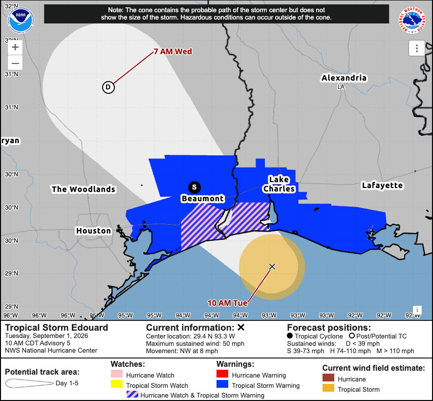
**Tropical Storm Edouard is expected to reach the northwestern Gulf Coast later today, bringing the threat of damaging winds, life-threatening storm surge, flooding rain and a tornado or two to parts of Texas and Louisiana.**
Tropical Storm Edouard is strengthening as it approaches the northwestern Gulf Coast.
As of 10 a.m. CDT, Edouard had **maximum sustained winds of 50 mph** and was moving northwest at 8 mph. Additional strengthening is forecast before landfall, and **Edouard could approach hurricane strength** before reaching the coast later today.
The center is forecast to move inland over southeast Texas tonight, with rapid weakening expected once the storm moves over land.
## Watches and Warnings
Several tropical alerts are in effect along the Texas and Louisiana coasts:
* **Storm Surge Warning:** High Island, Texas, to the Vermilion/Cameron Parish line in Louisiana
* **Hurricane Watch:** High Island, Texas, to Cameron, Louisiana
* **Tropical Storm Warning:** Port Bolivar, Texas, to the Vermilion/Iberia Parish line in Louisiana
Tropical storm conditions are expected to spread into portions of the warning area within the next few hours, while **hurricane conditions are possible within the Hurricane Watch area later today.**
Residents should follow evacuation orders and other instructions from local officials.
## Life-Threatening Storm Surge Possible
Storm surge is one of the biggest concerns as Edouard approaches the coast.
Water could rise **3 to 5 feet above ground** from High Island, Texas, to the Vermilion/Cameron Parish line in Louisiana if peak surge occurs around high tide.
Farther east, **1 to 3 feet of storm surge** is possible from the Vermilion/Cameron Parish line to Morgan City, Louisiana.
The deepest water is expected along the immediate coast near and to the right of Edouard's center. Conditions can vary significantly over short distances depending on the storm's exact track and the timing of the tide.
## Up to 9 Inches of Rain
Heavy rainfall will also create a significant flooding threat.
Edouard is expected to produce **3 to 6 inches of rain**, with localized totals up to **9 inches**, from the Upper Texas Coast into east-central Texas.
Far southwest Louisiana could receive **2 to 4 inches**.
Flash flooding is likely, particularly in low-lying and urban areas, and some river flooding is also possible.
## Tornado Threat
A **tornado or two is possible** across portions of southeast Texas and southwest Louisiana this afternoon and evening.
## What to Do Before Edouard Arrives
With conditions expected to deteriorate quickly, now is the time to finish preparations.
Those in affected areas should **follow instructions from local officials, avoid flooded roads and areas, keep weather alerts turned on and have a safe place to shelter** if a tornado warning is issued.
Storm surge can make normally dry coastal areas dangerous or impassable. If local officials tell you to evacuate, don't wait for conditions to worsen.
**Keep checking WeatherBug for the latest forecast, radar and alerts as Tropical Storm Edouard approaches the Gulf Coast.**
We use technologies, such as cookies, to analyze your use (i.e., pages visited), to customize content, for our internal analytics purposes and for security and other purposes. By continuing to use this website, you agree to this usage. Please review our [privacy policy](/legal/privacy) for more details as well as for information on how to contact us to object to these activities. [Ad Choices](/legal/privacy#digitaladvertisingandyourchoices)
```json
{"@context":"https://schema.org","@type":"NewsArticle","mainEntityOfPage":{"@type":"WebPage","@id":"https://www.weatherbug.com/news/Tropical-Disturbance-Forming-Near-Louisiana-Coast"},"headline":"Tropical Storm Edouard Nears Texas Coast, Could Approach Hurricane Strength","description":"Tropical Storm Edouard is expected to reach the northwestern Gulf Coast later today, bringing the threat of damaging winds, life-threatening storm surge, flooding rain and a tornado or two to parts of Texas and Louisiana.","image":["https://cms-assets-con.cdn.weatherbug.net/assets/contentitems/d9/d9eea676-b343-46ef-b55f-afb6b7fae0b6/52e0ce98-d40a-4283-82d1-d0fe816ebf4b/fcd27dd8-37b5-4563-b0ad-980bc65721d7.png"],"datePublished":"2026-09-01T15:16:14Z","dateModified":"2026-09-01T15:16:14Z","dateCreated":"2026-08-30T20:51:51Z","articleSection":"Weather News","keywords":"tropics,map,maps,rain,wind,Texas,Atlantic,Gulf","articleBody":"Tropical Storm Edouard is expected to reach the northwestern Gulf Coast later today, bringing the threat of damaging winds, life-threatening storm surge, flooding rain and a tornado or two to parts of Texas and Louisiana.
Tropical Storm Edouard is strengthening as it approaches the northwestern Gulf Coast.
As of 10 a.m. CDT, Edouard had maximum sustained winds of 50 mph and was moving northwest at 8 mph. Additional strengthening is forecast before landfall, and Edouard could approach hurricane strength before reaching the coast later today.
The center is forecast to move inland over southeast Texas tonight, with rapid weakening expected once the storm moves over land.
Watches and Warnings
Several tropical alerts are in effect along the Texas and Louisiana coasts:
- Storm Surge Warning: High Island, Texas, to the Vermilion/Cameron Parish line in Louisiana
- Hurricane Watch: High Island, Texas, to Cameron, Louisiana
- Tropical Storm Warning: Port Bolivar, Texas, to the Vermilion/Iberia Parish line in Louisiana
Tropical storm conditions are expected to spread into portions of the warning area within the next few hours, while hurricane conditions are possible within the Hurricane Watch area later today.
Residents should follow evacuation orders and other instructions from local officials.
Life-Threatening Storm Surge Possible
Storm surge is one of the biggest concerns as Edouard approaches the coast.
Water could rise 3 to 5 feet above ground from High Island, Texas, to the Vermilion/Cameron Parish line in Louisiana if peak surge occurs around high tide.
Farther east, 1 to 3 feet of storm surge is possible from the Vermilion/Cameron Parish line to Morgan City, Louisiana.
The deepest water is expected along the immediate coast near and to the right of Edouard's center. Conditions can vary significantly over short distances depending on the storm's exact track and the timing of the tide.
Up to 9 Inches of Rain
Heavy rainfall will also create a significant flooding threat.
Edouard is expected to produce 3 to 6 inches of rain, with localized totals up to 9 inches, from the Upper Texas Coast into east-central Texas.
Far southwest Louisiana could receive 2 to 4 inches.
Flash flooding is likely, particularly in low-lying and urban areas, and some river flooding is also possible.
Tornado Threat
A tornado or two is possible across portions of southeast Texas and southwest Louisiana this afternoon and evening.
What to Do Before Edouard Arrives
With conditions expected to deteriorate quickly, now is the time to finish preparations.
Those in affected areas should follow instructions from local officials, avoid flooded roads and areas, keep weather alerts turned on and have a safe place to shelter if a tornado warning is issued.
Storm surge can make normally dry coastal areas dangerous or impassable. If local officials tell you to evacuate, don't wait for conditions to worsen.
Keep checking WeatherBug for the latest forecast, radar and alerts as Tropical Storm Edouard approaches the Gulf Coast.
","author":{"@type":"Person","name":"UPDATED by WeatherBug Meteorologist Brittney Gomez","url":"https://www.weatherbug.com"},"publisher":{"@type":"Organization","name":"WeatherBug","logo":{"@type":"ImageObject","url":"https://www.weatherbug.com/images/sharing/f1ff28ba-6f06-4745-a782-011a20397e16.png"}}}
{"@context":"https://schema.org","@type":"WebSite","mainEntityOfPage":{"@type":"WebPage","@id":"https://www.weatherbug.com/news/Tropical-Disturbance-Forming-Near-Louisiana-Coast","relatedLink":"https://www.weatherbug.com/news/Tropical-Disturbance-Forming-Near-Louisiana-Coast"},"name":"WeatherBug","url":"https://www.weatherbug.com/news/Tropical-Disturbance-Forming-Near-Louisiana-Coast","headline":"Tropical Storm Edouard Nears Texas Coast, Could Approach Hurricane Strength","description":"Tropical Storm Edouard is expected to reach the northwestern Gulf Coast later today, bringing the threat of damaging winds, life-threatening storm surge, flooding rain and a tornado or two to parts of Texas and Louisiana.","dateModified":"2026-09-01T15:16:14Z","publisher":{"@type":"Organization","name":"WeatherBug","url":"https://www.weatherbug.com","sameAs":["https://www.facebook.com/WeatherBug","https://instagram.com/WeatherBug","https://www.linkedin.com/company/weatherbug","https://www.pinterest.com/weatherbug","https://twitter.com/WeatherBug","https://www.youtube.com/user/WeatherBugVideo"],"logo":{"@type":"ImageObject","url":"https://www.weatherbug.com/images/logos/weatherbug_logo_620x447.png"}},"author":{"@type":"Organization","name":"WeatherBug","url":"https://www.weatherbug.com","sameAs":["https://www.facebook.com/WeatherBug","https://instagram.com/WeatherBug","https://www.linkedin.com/company/weatherbug","https://www.pinterest.com/weatherbug","https://twitter.com/WeatherBug","https://www.youtube.com/user/WeatherBugVideo"],"logo":{"@type":"ImageObject","url":"https://www.weatherbug.com/images/logos/weatherbug_logo_620x447.png"}}}
{"@context":"https://schema.org","@type":"Organization","name":"WeatherBug","logo":"https://www.weatherbug.com/images/logos/weatherbug_logo_620x447.png","url":"https://www.weatherbug.com","sameAs":["https://www.facebook.com/WeatherBug","https://instagram.com/WeatherBug","https://www.linkedin.com/company/weatherbug","https://www.pinterest.com/weatherbug","https://twitter.com/WeatherBug","https://www.youtube.com/user/WeatherBugVideo"]}
```