Extended Weekend Weather Outlook
New year, new weather pattern? Not quite… A soggy, snowy forecast persists in both the Eastern and Western U.S. through the end of the weekend. While not as widespread, the nation’s midsection could also see periods of unsettled weather through Sunday.
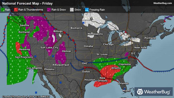
Friday
Wet weather will remain in the forecast for the Western U.S. on Friday. Rain showers and mountain snow are in store for the interior West, Pacific Northwest, Great Basin, and Four Corners. This activity will slowly disappear as the day goes on. However, another system will come barreling into the West Coast during the evening. Heavy rain will move back into central and northern California late in the night and into Saturday.
There will be a low pressure system that develops in the southern Plains, Mid-South, and Deep South. This will help fuel light to moderate rain from eastern Oklahoma and eastern Texas to Tennessee, Alabama, and northwestern Georgia.
In the Great Lakes, lake-effect snow prone areas will continue to see snow find its way to the ground. Some locations could see bright shining sun, and others could see over a foot of snow depending on the exact wind direction! The best chance for accumulating will be in areas east of Lake Erie and Lake Ontario.
Elsewhere, the weather will be quiet and dry, including the central and northern Plains, Midwest, Ohio Valley, New England, and Mid-Atlantic.
Frigid air in the single digits and teens is likely for the northern Plains, Upper Midwest, and interior Northeast. High terrain of the Rockies will feel 20s and 30s as well as the Lower Midwest, Ohio Valley, coastal Northeast, and northern Mid-Atlantic. Thirties and 40s are expected in the southern Mid-Atlantic, Tennessee Valley, and Pacific Northwest.
Temperatures in the 40s and 50s will be common in the central Plains, Great Basin, Four Corners, and central West Coast. The Southeast, southern Plains, Mid-South and southern West Coast will see a mix of 50s, 60s, and 70s. The Deep South and western Gulf Coast will enjoy 70s and even a few 80s in southern Texas.
Saturday
Another clipper system will quickly dart across the northern Plains and Great Lakes to start the weekend. This will bring additional rounds of snow but expect mainly light accumulations. Additional flurries or light snow showers could also be found in the interior Northeast during the morning as a fast-moving disturbance moves into Atlantic Canada.
The low pressure system that developed in the south-central U.S. on Friday will advance into the Southeast and then the Atlantic Ocean. Expect rain showers for the Tennessee Valley, Gulf Coast, and Southeast, while colder air over the central and southern Appalachians and southern Mid-Atlantic could create a wintry mix. Expect freezing rain over the Appalachians and then a light mix of snow, sleet, and rain across portions of southern Virginia and the southern Delmarva Peninsula.
Meanwhile, a Pacific storm system will move farther into the Western U.S. Precipitation will spread west-to-east throughout the day, starting first in the Northwest and northern California. This precipitation should make it to the northern Rockies, Great Basin and Desert Southwest by late Saturday night. The coast and lower elevations will see light to moderate rain, with perhaps briefly heavy rain at times. The middle elevations can expect rain during the day, which could mix with or even turn to wet snow at night. Expect snow for the mountains and higher elevations, with heavy snow accumulating in the Sierra Nevada.
The rest of the Rockies, the central and Plains, and southern half of the Mississippi Valley will stay dry under high pressure.
Bitter cold temperatures are in store for the north-central and northeastern U.S. Highs will generally be in the teens and 20s, but areas right along the U.S.-Canada border will be lucky to see the mercury climb into single digits. A few spots in northern Maine could also stay below zero. Temperatures will peak in the 30s and 40s for the Mountain West as well as the Mid-Mississippi and Tennessee valleys, and the Mid-Atlantic. Milder 50s and 60s will occur for the Pacific Northwest, much of California, the central and southern High Plains, and northern portions of the Deep South and Southeast. Seventies will be widespread for the Desert Southwest into the south-central U.S. and Southeast.
Sunday
A developing low pressure system will move away from the Rockies and into the north-central U.S. on Sunday. There will be a limited amount of moisture associated with it as it inches across the northern Plains in the morning but expect a slight chance of a wintry mix of rain and freezing rain. It then starts to have more moisture as it strengthens in the afternoon and evening. Some freezing rain will be possible across North Dakota, while Minnesota sees a mix of freezing rain, snow, and sleet. Mainly snow is expected across the Great Lakes in the evening, possibly becoming heavy at times.
A new upper-level weather system will move just off the West Coast to end the weekend. This will continue to send in plenty of Pacific moisture into the Western U.S. All areas west of the Rockies see some type of precipitation as well as the northern Plains. Rain continues to soak the coast and lower elevations, with a rain/snow mix for the middle elevations. Snow is anticipated for the mountains and higher elevations, with heavy to very heavy snow piling up even more in the Sierra Nevada.
Besides early flurries in the Northeast and a few showers for the Florida Peninsula, the Eastern Seaboard should stay dry. Much of the Four Corners states, the central/southern Plains and Lower Mississippi Valley will also stay worry-free.
Temperatures on Sunday will be similar to those on Saturday. The north-central and northeastern U.S. will experience teens and 20s, with single digits to below zero closer to Canada. Expect 30s and 40s for the Mountain West, though the tallest peaks could only see highs in the 20s. The Lower Midwest into the Mid-Atlantic will also record highs in the 30s and 40s. Expect 50s and 60s for the Pacific Northwest and most of California as well as the central and southern High Plains, Deep South and Southeast. Seventies will occur in the typical warm spots of the Desert Southwest, parts of Texas and southern Florida.