Back to forecast
2024-2025 Winter Outlook: La Niña Dominates U.S. Winter Pattern
November 19, 2024 at 08:44 AM EST
By WeatherBug Meteorologists
The big story last winter was the development of a strong El Niño pattern. Now, La Niña is back this winter and will be the primary influence on the winter outlook. AEM meteorologists, in conjunction with WeatherBug, released their winter outlook on November 18, and are forecasting a major change since last year.
With one of the stronger El Niño events in control last winter, most of the U.S. saw above normal temperatures from December to March. “It was especially warm across the Midwest, Great Lakes and interior Northeast as the jet stream hovered to the north of them,” said AEM Meteorologist Rob Richards. The 2023-2024 winter season was the warmest on record for the Upper Midwest and the contiguous U.S.
Precipitation also followed a classic El Niño pattern across the U.S. last winter. AEM Meteorologist Rob Richards says, “most of the West Coast, the southern U.S. and the Eastern Seaboard had above normal rain and snow. However, a small portion of the Tennessee Valley observed below average precipitation.”
The El Niño Southern Oscillation, or ENSO, was the main factor considered for the 2024-2025 Winter Outlook. “While current sea surface temperatures are in a Neutral phase, there has been a considerable cooling trend in the equatorial Pacific. La Niña is forecast to develop by the winter, remaining in a weak phase into spring,” said AEM Meteorologist Alyssa Robinette.
The Pacific Decadal Oscillation, or the PDO, is often described as a long-lived El Niño-like pattern. The extreme phases from the PDO are also classified by sea surface temperatures either being warm or cool in the interior North Pacific and along the U.S. East Coast. The PDO often tracks along with ENSO and the effects can be enhanced when both are in the same phase. AEM meteorologist Alyssa Robinette added, “a negative phase of the PDO developed earlier this year and should continue through most of 2025.”
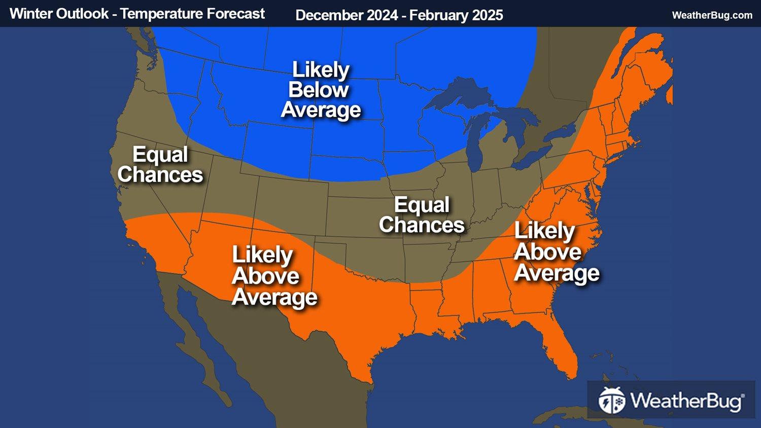
This outlook considers both ENSO and the PDO to be in sync this year, with a La Niña (or cool phase of ENSO) and a cool phase of the PDO. Typically, this will produce higher rainfall and mountain snow for the Northwest and Midwest to Ohio Valley, while most of the Southern U.S. is typically drier than normal. Colder than normal temperatures are usually found in the north-central U.S., with warmth overwhelming the southern Plains, Deep South and Southeast.
In addition to the influence from La Niña and a cool PDO phase, other minor factors played a role in this winter’s forecast, including a positive Quasi-Biennial Oscillation (QBO), a more active Madden-Julian Oscillation (MJO) and the solar maximum occurring.
The QBO is a cycle of high-altitude winds that blow easterly or westerly in a belt around the equator, which can impact global circulation pattern. “A positive QBO, or a westerly phase, would likely mean a weaker polar vortex and a lower chance for Arctic air intrusions,” said AEM meteorologist Alyssa Robinette.
The MJO is a wave of enhanced convection followed by a zone of suppressed convection along the equator that moves eastward from the Indian Ocean into the Pacific Ocean over a 30- to 60-day period. “The MJO is typically more active during weak La Nina years,” said AEM Meteorologist John Benedict. “Phases in this active MJO would favor above normal temperatures across much of the eastern and central U.S., and generally above normal rain and snow for the Great Lakes, Mississippi and Ohio valleys and the Pacific Northwest,” he added.
During a solar maximum, the polar vortex tends to be more constricted to the higher latitudes. “However, when it is coupled with a westerly QBO, there is a tendency for increased blocking and periodic stratospheric warming episodes, which could occasionally lead to cold air outbreaks extending farther south, especially during the second half of winter,” stated by AEM Meteorologist John Benedict.
All these factors combined will lead to increased chances of the following:
The Climate Prediction Center (CPC) released their winter outlook on October 17. They are also calling for below average temperatures from the Northwest to the north-central U.S., while unusual warm is in store for most of the Southern U.S. and Eastern Seaboard. They highlight two areas where there is the greatest chance of above normal rain and snowfall, which are over the Northwest and Great Lakes. The CPC also favor the Southern U.S. for having below average precipitation this winter.
With one of the stronger El Niño events in control last winter, most of the U.S. saw above normal temperatures from December to March. “It was especially warm across the Midwest, Great Lakes and interior Northeast as the jet stream hovered to the north of them,” said AEM Meteorologist Rob Richards. The 2023-2024 winter season was the warmest on record for the Upper Midwest and the contiguous U.S.
Precipitation also followed a classic El Niño pattern across the U.S. last winter. AEM Meteorologist Rob Richards says, “most of the West Coast, the southern U.S. and the Eastern Seaboard had above normal rain and snow. However, a small portion of the Tennessee Valley observed below average precipitation.”
The El Niño Southern Oscillation, or ENSO, was the main factor considered for the 2024-2025 Winter Outlook. “While current sea surface temperatures are in a Neutral phase, there has been a considerable cooling trend in the equatorial Pacific. La Niña is forecast to develop by the winter, remaining in a weak phase into spring,” said AEM Meteorologist Alyssa Robinette.
The Pacific Decadal Oscillation, or the PDO, is often described as a long-lived El Niño-like pattern. The extreme phases from the PDO are also classified by sea surface temperatures either being warm or cool in the interior North Pacific and along the U.S. East Coast. The PDO often tracks along with ENSO and the effects can be enhanced when both are in the same phase. AEM meteorologist Alyssa Robinette added, “a negative phase of the PDO developed earlier this year and should continue through most of 2025.”
This outlook considers both ENSO and the PDO to be in sync this year, with a La Niña (or cool phase of ENSO) and a cool phase of the PDO. Typically, this will produce higher rainfall and mountain snow for the Northwest and Midwest to Ohio Valley, while most of the Southern U.S. is typically drier than normal. Colder than normal temperatures are usually found in the north-central U.S., with warmth overwhelming the southern Plains, Deep South and Southeast.
In addition to the influence from La Niña and a cool PDO phase, other minor factors played a role in this winter’s forecast, including a positive Quasi-Biennial Oscillation (QBO), a more active Madden-Julian Oscillation (MJO) and the solar maximum occurring.
The QBO is a cycle of high-altitude winds that blow easterly or westerly in a belt around the equator, which can impact global circulation pattern. “A positive QBO, or a westerly phase, would likely mean a weaker polar vortex and a lower chance for Arctic air intrusions,” said AEM meteorologist Alyssa Robinette.
The MJO is a wave of enhanced convection followed by a zone of suppressed convection along the equator that moves eastward from the Indian Ocean into the Pacific Ocean over a 30- to 60-day period. “The MJO is typically more active during weak La Nina years,” said AEM Meteorologist John Benedict. “Phases in this active MJO would favor above normal temperatures across much of the eastern and central U.S., and generally above normal rain and snow for the Great Lakes, Mississippi and Ohio valleys and the Pacific Northwest,” he added.
During a solar maximum, the polar vortex tends to be more constricted to the higher latitudes. “However, when it is coupled with a westerly QBO, there is a tendency for increased blocking and periodic stratospheric warming episodes, which could occasionally lead to cold air outbreaks extending farther south, especially during the second half of winter,” stated by AEM Meteorologist John Benedict.
All these factors combined will lead to increased chances of the following:
- Below average temperatures across the north-central U.S.: With the jet stream dipping farther south, there could be more frequent cold outbreak for the western Great Lakes, Upper Midwest, northern Plains, northern Rockies and even into the Northwest.
- Unseasonably warm for the East Coast and most of the Southern Tier: The jet stream will likely not drop far enough south or east to allow weather systems to move across the East Coast, Gulf Coast, southern Plains and southwest. Even worse, southerly winds south of the jet stream will pump warm air into these regions.
- Snowy season for the Northern Tier: Above average precipitation will be likely here given more frequent weather systems. Combined with below normal temperatures, above average snowfall is favored for the Northwest, northern Rockies, northern Plains, Upper Midwest and parts of the Northeast. Drought improvement and/or removal will also be likely here.
- Expanding drought for the Southern U.S.: With a less active weather pattern, it will likely be drier than normal across the South. Drought persistence and/or expansion is favored across the Southern Tier, especially in Texas.
- Severe weather outbreaks for eastern half of the U.S.: Severe weather outbreaks will be most favored when temperatures are warmer than normal in the East, with below average temperatures in the West. This will cause the air masses to clash and produce severe weather for the Lower and Middle Mississippi River Valley as well as the Ohio and Tennessee valleys.
The Climate Prediction Center (CPC) released their winter outlook on October 17. They are also calling for below average temperatures from the Northwest to the north-central U.S., while unusual warm is in store for most of the Southern U.S. and Eastern Seaboard. They highlight two areas where there is the greatest chance of above normal rain and snowfall, which are over the Northwest and Great Lakes. The CPC also favor the Southern U.S. for having below average precipitation this winter.