Back to Hurricane Alerts
2025-2026 Winter Outlook: La Niña Main Factor This Winter
November 5, 2025 at 11:47 PM EST
By WeatherBug Meteorologist, Alyssa Robinette
The big story last winter was the swing from a strong El Niño pattern to a La Niña. Now, La Niña continues to be in the headlines, but several other factors could be in play this winter. AEM meteorologists, in collaboration with WeatherBug, released their winter outlook on November 5.
A weak La Niña pattern was in control last winter, which allowed much of the U.S. to be colder than normal for the months of December, January and February. The exceptions would be the Southwest, a few parts of the south-central U.S. and far southern Florida. However, AEM meteorologist, Kyle Leahy, says, “the months leading up to and following meteorological winter (November and March) were relatively warm for most of the U.S., which completely overwhelmed, at least statistically speaking, the cold.”
In terms of precipitation, it followed a typical La Niña pattern, with precipitation averaging below normal throughout much of the Southern Tier and the Eastern Seaboard. There were pockets of above-average precipitation for parts of the Northwest and Midwest.
Here we will look at the factors examined for the 2025-2026 Winter Outlook:
El Niño Southern Oscillation
The El Niño Southern Oscillation, or ENSO, is a periodic, cyclical warming or cooling of the equatorial Pacific Ocean. Currently, the equatorial Pacific sea surface temperatures are only slightly below normal, or in a cool neutral phase. Leahy says, “recent trends suggest that a weak La Niña pattern will peak late fall or early winter, then trend neutral by the end of winter.”
Typical La Niña winter impacts include additional wetness for the Northwest and Midwest to the Ohio Valley, colder than normal temperatures across the north-central U.S., drier conditions across most of the Southern U.S. and warmer temperatures overwhelming the southern Plains, Deep South and Southeast.
Pacific Decadal Oscillation
The Pacific Decadal Oscillation, or the PDO, is often described as a long-lived El Niño-like pattern. The extreme phases from the PDO are also classified by sea surface temperatures, either being warm or cool in the interior North Pacific and along the U.S. West Coast. The PDO often tracks along with ENSO, and the effects can be enhanced when both are in the same phase. The PDO is currently strongly negative and will likely stay that way.
With a typical negative PDO pattern, ridges of high pressure set up over both coasts, while an upper-level trough of low pressure sits over the nation’s midsection. This usually results in the northern Plains being colder than normal, and the Southwest and Southeast averaging warmer.
Analog Years
An analog is defined as something that is similar or comparable to something else, either in general or in some specific detail. For our purposes, we develop “analog years,” or where we link prior years with how we think this winter will unfold using pattern recognition. Unfortunately, there is no such thing as a perfect analog.
For a winter outlook, we gather several “decent fits,” usually somewhere between six to ten years. This helps get a sense of the range of possible deviations and outcomes. “Analog years were focused this year on neutral to weak La Niña winters coupled with a negative phase of the PDO,” says Leahy.
Solar Activity
According to AEM meteorologist, Mark Paquette, “we are now reaching the solar maximum in the 11-year cycle, which began late 2019.” During solar maximum, the polar vortex tends to be more constricted to the higher latitudes. This also translates into below normal snow accumulations.
Siberian Snow Cover
Siberian snow cover is currently running at or above normal. Paquette said, “This is a shift from recent years, which had been near, if not, below normal.” Extra snow and ice cover can allow pools of colder air to be more prevalent. This increased snow cover could help define or locate the pattern mentioned in the Pacific Decadal Oscillation section, or ridges of high pressure along both coasts and an upper-level trough of low pressure in the Central U.S.
Long-Range Climate Models
Long-range climate models can be helpful to watch for trends and which way to lean with some of the spread that the analog years give. However, long-range climate models should be used with care as there can be large swings.
Paquette says, “These climate models have the same general idea in terms of their placement of the cold and warm anomalies.” They show a cold interior Canada and north-central U.S., with a mild southern U.S.“ Above normal precipitation is favored for the Pacific Northwest as well as into a good portion of the Midwest and Great Lakes. Meanwhile, below normal precipitation is favored across the Southern U.S., especially for Florida and California.”
Expected Pattern for Winter 2025-2026
When you put all these factors together, there are several similarities to a La Niña pattern. AEM meteorologists are projecting an active polar jet stream out of Canada into the northern U.S., likely making it colder than normal across the north-central U.S. High pressure will set up somewhere off the West Coast, with the precise placement being very important. There will also most likely be a relatively weak subtropical jet stream.
Predicted impacts for the U.S. include:
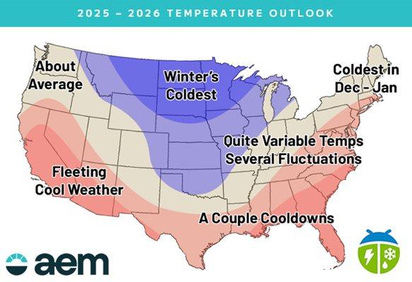
Temperature
Severe weather during the winter season is greatly affected by ENSO, with an increased risk during La Nina years. This year we are expecting a weak La Nina pattern, but looking ahead, temperature and precipitation patterns overall point to a greater threat for severe weather episodes this winter.
A weak La Niña pattern was in control last winter, which allowed much of the U.S. to be colder than normal for the months of December, January and February. The exceptions would be the Southwest, a few parts of the south-central U.S. and far southern Florida. However, AEM meteorologist, Kyle Leahy, says, “the months leading up to and following meteorological winter (November and March) were relatively warm for most of the U.S., which completely overwhelmed, at least statistically speaking, the cold.”
In terms of precipitation, it followed a typical La Niña pattern, with precipitation averaging below normal throughout much of the Southern Tier and the Eastern Seaboard. There were pockets of above-average precipitation for parts of the Northwest and Midwest.
Here we will look at the factors examined for the 2025-2026 Winter Outlook:
El Niño Southern Oscillation
The El Niño Southern Oscillation, or ENSO, is a periodic, cyclical warming or cooling of the equatorial Pacific Ocean. Currently, the equatorial Pacific sea surface temperatures are only slightly below normal, or in a cool neutral phase. Leahy says, “recent trends suggest that a weak La Niña pattern will peak late fall or early winter, then trend neutral by the end of winter.”
Typical La Niña winter impacts include additional wetness for the Northwest and Midwest to the Ohio Valley, colder than normal temperatures across the north-central U.S., drier conditions across most of the Southern U.S. and warmer temperatures overwhelming the southern Plains, Deep South and Southeast.
Pacific Decadal Oscillation
The Pacific Decadal Oscillation, or the PDO, is often described as a long-lived El Niño-like pattern. The extreme phases from the PDO are also classified by sea surface temperatures, either being warm or cool in the interior North Pacific and along the U.S. West Coast. The PDO often tracks along with ENSO, and the effects can be enhanced when both are in the same phase. The PDO is currently strongly negative and will likely stay that way.
With a typical negative PDO pattern, ridges of high pressure set up over both coasts, while an upper-level trough of low pressure sits over the nation’s midsection. This usually results in the northern Plains being colder than normal, and the Southwest and Southeast averaging warmer.
Analog Years
An analog is defined as something that is similar or comparable to something else, either in general or in some specific detail. For our purposes, we develop “analog years,” or where we link prior years with how we think this winter will unfold using pattern recognition. Unfortunately, there is no such thing as a perfect analog.
For a winter outlook, we gather several “decent fits,” usually somewhere between six to ten years. This helps get a sense of the range of possible deviations and outcomes. “Analog years were focused this year on neutral to weak La Niña winters coupled with a negative phase of the PDO,” says Leahy.
Solar Activity
According to AEM meteorologist, Mark Paquette, “we are now reaching the solar maximum in the 11-year cycle, which began late 2019.” During solar maximum, the polar vortex tends to be more constricted to the higher latitudes. This also translates into below normal snow accumulations.
Siberian Snow Cover
Siberian snow cover is currently running at or above normal. Paquette said, “This is a shift from recent years, which had been near, if not, below normal.” Extra snow and ice cover can allow pools of colder air to be more prevalent. This increased snow cover could help define or locate the pattern mentioned in the Pacific Decadal Oscillation section, or ridges of high pressure along both coasts and an upper-level trough of low pressure in the Central U.S.
Long-Range Climate Models
Long-range climate models can be helpful to watch for trends and which way to lean with some of the spread that the analog years give. However, long-range climate models should be used with care as there can be large swings.
Paquette says, “These climate models have the same general idea in terms of their placement of the cold and warm anomalies.” They show a cold interior Canada and north-central U.S., with a mild southern U.S.“ Above normal precipitation is favored for the Pacific Northwest as well as into a good portion of the Midwest and Great Lakes. Meanwhile, below normal precipitation is favored across the Southern U.S., especially for Florida and California.”
Expected Pattern for Winter 2025-2026
When you put all these factors together, there are several similarities to a La Niña pattern. AEM meteorologists are projecting an active polar jet stream out of Canada into the northern U.S., likely making it colder than normal across the north-central U.S. High pressure will set up somewhere off the West Coast, with the precise placement being very important. There will also most likely be a relatively weak subtropical jet stream.
Predicted impacts for the U.S. include:
Temperature
- Several arctic blasts are expected to march south or southeastward from Canada, with their greatest impacts on the northern and central Plains as well as the Midwest and Great Lakes.
- The Northeast and Mid-Atlantic will likely see the coldest part of the winter early in the season.
- The battleground between the warm and cold from the Plains to the Northeast will likely experience several significant fluctuations.
- By the time the arctic air reaches the Southern Tier, it will usually be modified and generally will not last for long.
- The combination of cold air, warm Great Lakes, and an active storm track likely leads to above-normal precipitation for much of the Great Lakes and Ohio Valley.
- The northern Rockies and northern Plains are favored for snow with above-normal precipitation combined with arctic air.
- Below-average precipitation is favored for much of the Western and Southern U.S.
- Even though the East may see slightly below normal precipitation, it should be more active than it has been recently.
- Great Lakes snow belts look poised to see several impactful events, potentially with an early start to the snow season.
- An active storm track near the East Coast gives the potential for numerous small to medium snow and ice events. A large Nor'easter (or two) can't be ruled out.
- The northern Plains and northern Rockies could see more snow than usual while a quieter-than-normal southern jet stream could lead to an overall dry winter for the Southern Tier.
- Over 70% of the U.S. is abnormally dry or experiencing drought, which has been increasing and is up about 15% over the last five weeks.
- Heading into the winter season, the Southwest will be the spot to watch for increasing drought and abnormally dry conditions. This is due to the predicted warmer and drier than normal weather.
- Drought also looks to intensify and shift eastward across much of the South thanks to a weaker than normal subtropical jet stream.
- Conversely, the Northwest into parts of the northern Plains will likely see improving drought conditions as will parts of the Midwest and Ohio Valley.
- While becoming increasingly out of season for much of the nation due to colder temperatures, and in some instances more precipitation, as we have already seen, much of the country is currently abnormally dry or in drought.
- This is particularly concerning in the South where our outlook calls for less precipitation than normal, and we expect expansion of the drought.
- While the coverage of higher fire risk should shrink through the winter season, we will have to carefully monitor this into the spring and beyond, as the cumulative lack of precipitation could refocus concerns across the Southwest, Mid-South, Appalachians and maybe even the Mid-Atlantic and Northeast.
Severe weather during the winter season is greatly affected by ENSO, with an increased risk during La Nina years. This year we are expecting a weak La Nina pattern, but looking ahead, temperature and precipitation patterns overall point to a greater threat for severe weather episodes this winter.
- Greatest threat for winter severe weather outbreaks center on the Lower and Middle Mississippi valleys and into the Ohio and Tennessee valleys.
- Severe outbreaks are favored when temperatures in the East are warmer than normal and temperatures in the west are colder than normal, and then the air masses clash across the Mississippi and Ohio valleys.
- During La Nina years, Arkansas, Louisiana, Mississippi, Alabama, Illinois, Indiana and Michigan have more than 125% of normal tornadoes.