
Christmas Travel Outlook: Plenty of Travel Headaches Across The West
Christmas is quickly approaching, and we have the scoop on the travel forecast whether you’re driving to grandma’s house, jetting out to a tropical island, or having a lovely “staycation.”
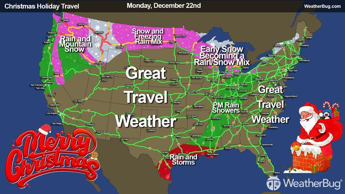
Monday
The main weather story on Monday will be a large weather system hovering off the West Coast, ready to transport multiple rounds of moisture into the Northwest, northern California, the Great Basin and northern Rockies. Precipitation will be widespread throughout these regions in the morning, which could briefly taper off or end in the afternoon. Another round of precipitation is expected Monday evening and night.
While lower elevations of Washington, Oregon and northern California see rain, the interior Northwest and the lowest elevations of the Rockies will likely see a rain/snow mix early and late on Monday, with moderate to heavy snow will be falling throughout the Cascades, the northern California mountains and the rest of the northern Rockies.
Travel impacts for those planning an early getaway along the West Coast include:
- The higher stretches of Interstates 15, 82 and 90 in the Northwest will likely see wet to occasionally slick roads throughout Monday, becoming icy overnight. The worst conditions will be along the passes, Snoqualmie Pass in Washington and Lookout Pass at the Montana/Idaho border, where snow will be commonplace. Donner Pass on the highest stretch of Interstate 80 in the Sierra Nevada will also face difficult, if not impossible, travel conditions due to road conditions, blowing snow and reduced visibility.
- Fortunately, the airports will fare somewhat better, with minor delays in Seattle and perhaps stretching into Sacramento, Calif., but remaining north of the major hubs of the San Francisco Bay Area.
Further east, a weather disturbance will be moving along a stalled cold front in the north-central U.S. With moisture limited, so will the chances of wintry precipitation. Even so, freezing rain or a wintry mix could still be found across the northern Plains in the morning and afternoon. It will then transition over to all snow as it pushes across the Upper Mississippi Valley in the evening and overnight.
East of there, a warm front will attempt to lift north across the Great Lakes throughout Monday, reaching the Mid-Atlantic and Northeast Monday night. Light to moderate snow will be found throughout the Lower Great Lakes into the early evening, with some freezing rain possibly mixing in at times. As temperatures warm along this cold front, snow will mix with and change over to rain across the Lower Great Lakes, with light snow pushing into the Upper Great Lakes. Rain showers will also become increasingly likely for the Ohio and Tennessee valleys in the evening and overnight.
Given chances for wintry precipitation, slick to slippery roads are possible across the far northern Plains in the morning and afternoon, which includes Interstate 94 in eastern Montana and North Dakota. Similarly, much of Wisconsin and the Lower Michigan Peninsula will see icy to snow roads on Monday morning, which includes Interstates 39, 43, 69, 75, 90 and 94. These roads will improve for the rest of Monday into early Tuesday morning, likely just staying wet. There will be a better chance of slick, icy roads in far northern Minnesota in the evening and overnight. Airport delays will be minimized, with Minneapolis, the Chicago airports and Detroit most likely to see minor delays due to the wintry weather.
The only other concern is along the western and central Gulf Coast, where a few showers and thunderstorms will be present. While possible throughout the day, the best chance for rain and storms will occur late morning into the early evening. Flights through New Orleans and Houston could be slightly delayed, but the storms shouldn’t be able to destroy your itinerary.
Otherwise, it will be smooth sailing in the air and on the ground for those travelling through the central Plains and South. Interstates 20, 30, 40 and 70 – just to name a few – will be among those that should be weather-free on Monday.
Tuesday
Heavy rain will start to push southward along the West Coast, making the Christmas getaway a bit soggy from the San Franciso Bay Area to Seattle. While clouds will be on the increase across southern California and Nevada, expect conditions to remain relatively dry. Tuesday will also feature some snow for the passes of Washington and Oregon, although this should lead to delays rather than road closures.
Travel delays across the West will be found on planes, trains and automobiles:
- While the Interstate 5 corridor will be wet but passable, expect to see some travel trouble if you plan to cross the Sierra Nevada along Interstate 80, or the Cascades along Interstates 84 and 90. Here, rain will change over to snow as you climb above 5000 to 6000 feet, meaning that snow chains may be necessary to get from Point A to Point B.
- In the air, Seattle and San Francisco will take the brunt of the weather impacts on Tuesday. Expect to have some minor delays at these airports, while Los Angeles and Las Vegas should remain dry throughout the day with little to no impact. Keeping with the theme, expect the famous views along Amtrak’s Coast Starliner to be a bit dulled by low clouds and fog.
Another area likely to see some weather trouble will be the Northeast, where a warm front will bring snow from upstate New York into New England and rain along its western fringe from the Mid-South to the eastern Great Lakes.
- Travel along the New York Thruway and Massachusetts Turnpike might not be particularly pleasant as snow accumulates on the road. Likewise, Interstate 80 and 86 across the Northern and Southern Tiers toward New York City will be snow-covered at times. The Interstate 79 and 81 corridors heading into Appalachia and the Mid-South will see rain-slickened roads.
- Airport delays should be limited from this weather, although flights originating in Albany, N.Y., Hartford, Conn., and Burlington, Vt., will be most likely to see trouble. New York and Boston should stay warm enough that as the precipitation reaches there later in the day, it will be in the form of rain.
If your plans take you across the Central U.S. or Rockies, or into the Southeast, Tuesday will be the day to do so. Sun glare will be the biggest concern on the roads, while major delays are not expected from Houston and Dallas-Fort Worth to Chicago’s O’Hare. Temperatures will also be on the mild side, with lots of 50s, 60s and 70s expected from Nebraska to the Ohio Valley and Mid-Atlantic and southward.
Wednesday (Christmas Eve)
The travel nightmare will continue into Christmas Eve, with yet another wave of heavy rain and mountain snow likely across the West from border to border. For California, the rain will be an all-day event for San Francisco and Los Angeles, with rain spreading into Las Vegas over the course of the morning.
If there’s any consolation, it is that the Pacific Northwest will see heavy rain in the morning tapering off to scattered showers in the afternoon. However, that rain will just track inland into Idaho and western Montana by nightfall. For the mountains and passes, the rain will fall as heavy snowfall, making travel difficult, if not impossible.
Travel Impacts will be plentiful:
- The entire Interstate 5 corridor from San Diego to Seattle and much of the Interstate 15 corridor from San Diego into southern Idaho will see rainfall on Wednesday. Expect ponding of water on the roads and delays as drivers slow down to avoid hydroplaning.
- Likewise, large stretches of the east-west corridors along the West Coast will see travel difficulties on Wednesday. If you must travel over the passes on Interstates 80, 84 or 90, expect to need snow chains and see heavy snowfall. The snow may even be heavy enough to close some of these passes for much of the day, so check with your state’s 511 for the latest information.
- Air traffic will also be a headache. Major West Coast hubs including Los Angeles, San Francisco, Las Vegas and Seattle will be inundated by heavy rain, which will cause reduced visibility, leading to delays. Smaller airports such as Spokane, Wash., Reno, Nev., and Boise, Idaho, will have their work cut out for them to keep travelers on their way to see family.
The only other spot likely to cause weather headaches is across the Midwest and western Ohio Valley. Here, a weak disturbance will bring a few rain showers from Milwaukee to Cincinnati.
Travel issues could exist as hydroplaning on the wet roads is still a concern. Interstates 55, 65, 70, 74, 80 and 90 will bear the brunt of the shower activity throughout the day. The good news is that the rain should be light enough to preclude any significant delays in Chicago, Cincinnati or Indianapolis.
For much of the rest of the country, the biggest travel concern will be “sunroof open or sunroof closed?” A push of warm air east of the Rockies will produce plenty of sunshine from Nebraska to the Eastern Seaboard, with temperatures reaching well into the 60s and 70s. While also sunny, cooler air will be found from the Dakotas to New England, with highs into the 20s and 30s for the most part, with 50s from Iowa to the Mid-Atlantic.
With all the pleasant late-December weather, travel issues aren’t expected from Minneapolis to New York and from Dallas-Fort Worth to Miami. Even Santa will find his travel quite easy in this part of the country on Christmas Eve.
Thursday (Christmas Day):
For the West, it will continue to be a broken record… rain and mountain snow even on Christmas. There will be no end in sight for rainfall across Oregon, California, Nevada and Arizona, making last-minute travel quite difficult.
Like Wednesday, the north-south corridors will be rain-swept, while the east-west corridors will feature high-elevation snowfall across the Cascades and Sierra Nevada. Adding into the fun will be the eastward expansion of the rain and snow, impacting travel across Utah and western Colorado with mountain snow. We at WeatherBug are eternal optimists, and the good news is the Interstate 25 corridor across Wyoming, Colorado and New Mexico should remain dry for most of the day. This will also limit the number of delays and cancellations out of Denver.
The Northern Tier will start to feel winter’s wrath again in the travel department on Thursday. Light snow occasionally mixed with freezing rain can be expected from North Dakota into northern Minnesota. Wintry weather should steer clear of Minneapolis for most, if not all, of the day. Likewise, travel from Ohio to New England could be impacted by a passing disturbance. Mountain areas of New York, Pennsylvania and New England could see passing snow showers, while periods of rain will plonk windshields along Interstates 80 and 90.
Any last-minute travelers across the rest of the country will enjoy quiet weather for the most part, with few travel hazards. Like Christmas Eve, unseasonably warm temperatures can be expected from the central and southern Plains to the Mid-Atlantic and Southeast, where 60s and 70s will be common under generally sunny conditions. Likewise, you might not be able to blame Mother Nature for airport delays across the East, although there will be some trickle-down impact from the West.
Stay tuned to WeatherBug over the coming days to see the forecast leading up to Christmas Day. We wish everyone Happy Holidays and a Happy New Year!