Back to forecast
6 Years Ago, A Destructive Derecho Thumped The Midwest, Mid-Atlantic
June 29, 2018 at 03:29 PM EDT
By WeatherBug Meteorologist, Andrew Rosenthal
Like a freight train, one of the worst severe storm outbreaks in U.S. history rumbled from the Midwest to the Mid-Atlantic six years ago. The storm system, known as a derecho, resulted in nearly two dozen deaths and damage that approached $3 billion.
A “derecho” is a quick-moving line of severe thunderstorms. Named from the Spanish word for “straight,” they can advance at speeds more than 60 mph while producing wind gusts in excess of hurricane intensity. The result can often be catastrophic tree and power line damage.
The stormy weather of June 29, 2012, started innocently enough as an area of thunderstorms in central Iowa. Slowly, the thunderstorms started to gain intensity that Friday morning as they tracked into Illinois.
A warm front was draped that day from Iowa, across the Chicago metro area through northern Indiana and Ohio and then southward into Pennsylvania. This warm front provided the key ingredient to turn the benign thunderstorm into a monster: extreme heat. Temperatures from Chicago to Washington, D.C., would surge past the triple-digit mark, providing plenty of fuel for thunderstorm development.
As the storm system advanced eastward past Chicago, severe thunderstorms started to develop, with a wind gust of 91 mph recorded in Fort Wayne, Ind. It then marched along the warm front across Ohio during the afternoon, producing wind gusts to 84 mph in Paulding and Findlay, and produced a tornado near Newcomerstown, Ohio.
The derecho would continue to steam along at highway speeds across the Appalachians that evening, placing its target clearly on the Mid-Atlantic, and specifically the Washington, D.C., metro area. Widespread wind gusts across central Maryland exceeded 70 mph, with a peak gust of 80 mph in Fredericksburg, Va., as it raced eastward that evening. Before exiting into the ocean early the next morning, the storm system produced a gust to 81 mph in Tuckerton, N.J.
Effects on human life along the storm’s path were immense. More than four million people lost power from Indiana to New Jersey and Delaware as power lines and trees snapped in the strong winds. Twenty-two people were killed by the storm, with all but a couple of these deaths caused by falling trees.
In all, damage due to the derecho was estimated at $2.9 billion, comparable to that of a major hurricane. Damage also included roofs being torn off buildings and even airplanes being flipped. As if the storm itself wasn’t bad enough, many in the Mid-Atlantic were without power for more than a week following the storm, coinciding with an extended heat wave across the region.
Derechos are not uncommon during the summer, particularly in hot weather patterns similar to the one in 2012. In fact, Indiana and Ohio experienced two other derechos that summer. Another one that occurred in Indiana, nearly two years later to the day, produced wind gusts to 110 mph. They have even been recorded across Europe and one particular derecho in Brazil in 2005 knocked down more than 500 million trees in the Amazon.
---
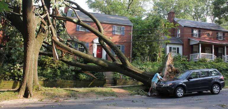
Story Image: Tree and power line damage is evident in Bethesda, Md., following the derecho (Wikimedia Commons)
A “derecho” is a quick-moving line of severe thunderstorms. Named from the Spanish word for “straight,” they can advance at speeds more than 60 mph while producing wind gusts in excess of hurricane intensity. The result can often be catastrophic tree and power line damage.
The stormy weather of June 29, 2012, started innocently enough as an area of thunderstorms in central Iowa. Slowly, the thunderstorms started to gain intensity that Friday morning as they tracked into Illinois.
A warm front was draped that day from Iowa, across the Chicago metro area through northern Indiana and Ohio and then southward into Pennsylvania. This warm front provided the key ingredient to turn the benign thunderstorm into a monster: extreme heat. Temperatures from Chicago to Washington, D.C., would surge past the triple-digit mark, providing plenty of fuel for thunderstorm development.
As the storm system advanced eastward past Chicago, severe thunderstorms started to develop, with a wind gust of 91 mph recorded in Fort Wayne, Ind. It then marched along the warm front across Ohio during the afternoon, producing wind gusts to 84 mph in Paulding and Findlay, and produced a tornado near Newcomerstown, Ohio.
The derecho would continue to steam along at highway speeds across the Appalachians that evening, placing its target clearly on the Mid-Atlantic, and specifically the Washington, D.C., metro area. Widespread wind gusts across central Maryland exceeded 70 mph, with a peak gust of 80 mph in Fredericksburg, Va., as it raced eastward that evening. Before exiting into the ocean early the next morning, the storm system produced a gust to 81 mph in Tuckerton, N.J.
Effects on human life along the storm’s path were immense. More than four million people lost power from Indiana to New Jersey and Delaware as power lines and trees snapped in the strong winds. Twenty-two people were killed by the storm, with all but a couple of these deaths caused by falling trees.
In all, damage due to the derecho was estimated at $2.9 billion, comparable to that of a major hurricane. Damage also included roofs being torn off buildings and even airplanes being flipped. As if the storm itself wasn’t bad enough, many in the Mid-Atlantic were without power for more than a week following the storm, coinciding with an extended heat wave across the region.
Derechos are not uncommon during the summer, particularly in hot weather patterns similar to the one in 2012. In fact, Indiana and Ohio experienced two other derechos that summer. Another one that occurred in Indiana, nearly two years later to the day, produced wind gusts to 110 mph. They have even been recorded across Europe and one particular derecho in Brazil in 2005 knocked down more than 500 million trees in the Amazon.
---
Story Image: Tree and power line damage is evident in Bethesda, Md., following the derecho (Wikimedia Commons)