Back to forecast
65 Years Ago, Hurricane Diane Bombarded The East Coast
August 18, 2020 at 07:35 PM EDT
By WeatherBug's Chris Sayles
65 years ago, the East Coast was bombarded by twin tropical trouble that would rack up the bill to the highest of that time. Hurricane Diane swept through the Mid-Atlantic and left a lasting impression from the Carolinas to New England.
The storm was first detected on August 7, 1955 as a tropical wave sweeping across the Atlantic Ocean. With a west-northwestward movement, this tropical wave would continue its path targeting the East Coast. It should be noted that this storm developed just a few days before Hurricane Connie made its way through the Delaware Valley. With little to no time to breathe, this new tropical threat looked to add to the problems sustained from the former storm.
As any tropical system in favorable conditions, the new disturbance would strengthen to Tropical Storm Diane on August 9 before reaching hurricane strength on the 11th. However, thanks to Hurricane Connie’s presence to the northeast of Diane, the two storms would become entrained and Diane would weaken due to a process known as the Fujiwhara Effect.
The idea behind this phenomenon is that whenever there are two tropical systems within the same region of each other, the two will not merge into one bigger storm, but meander around each other. Eventually, the weaker of the two systems would have its energy siphoned and one system would remain. In this case, Diane would be the one who would weaken, but not for long.
Connie would begin to move into the northern Atlantic which freed Diane to rapidly intensify. On August 13, Diane would strengthen to a Category 3 hurricane with peak winds estimated at about 120 mph. Now a major hurricane, Diane spelled additional trouble for the Mid-Atlantic who had just dealt with Hurricane Connie. Thankfully, the system would become disorganized as it approached the Carolina coastline. As such, Diane would make landfall near Wilmington, N.C., on August 17, 1955 as a Category 1 hurricane. This system would make a turn for the Northeast as it bombarded the Carolinas.
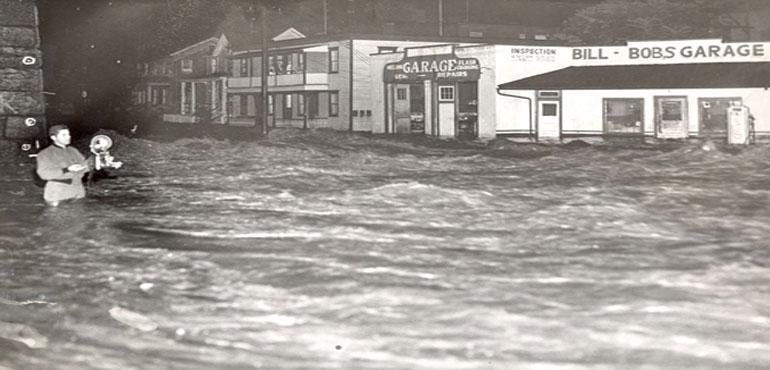
Heavy rainfall between 10 to 20 inches resulted in devastating flooding from North Carolina to New England from August 17 to August 20. Due to the short turnaround from Connie just days before, many people weren’t able to prepare for back-to-back tropical systems. This led to the deaths of over 180 people and an estimated $832 million in damages, making it the costliest storm of that time.
The extensive damage from the storm led to the name “Diane” being retired from the Atlantic hurricane naming list. It is not all bad though, as these tropical systems would pave the way for the National Hurricane Information Center to be established in 1956, becoming the National Hurricane Center in 1965.
Sources: NOAA, NHC, Weather Prediction Center
Story Image: New England flooding from Diane, August 1955. (Weather Prediction Center)
The storm was first detected on August 7, 1955 as a tropical wave sweeping across the Atlantic Ocean. With a west-northwestward movement, this tropical wave would continue its path targeting the East Coast. It should be noted that this storm developed just a few days before Hurricane Connie made its way through the Delaware Valley. With little to no time to breathe, this new tropical threat looked to add to the problems sustained from the former storm.
As any tropical system in favorable conditions, the new disturbance would strengthen to Tropical Storm Diane on August 9 before reaching hurricane strength on the 11th. However, thanks to Hurricane Connie’s presence to the northeast of Diane, the two storms would become entrained and Diane would weaken due to a process known as the Fujiwhara Effect.
The idea behind this phenomenon is that whenever there are two tropical systems within the same region of each other, the two will not merge into one bigger storm, but meander around each other. Eventually, the weaker of the two systems would have its energy siphoned and one system would remain. In this case, Diane would be the one who would weaken, but not for long.
Connie would begin to move into the northern Atlantic which freed Diane to rapidly intensify. On August 13, Diane would strengthen to a Category 3 hurricane with peak winds estimated at about 120 mph. Now a major hurricane, Diane spelled additional trouble for the Mid-Atlantic who had just dealt with Hurricane Connie. Thankfully, the system would become disorganized as it approached the Carolina coastline. As such, Diane would make landfall near Wilmington, N.C., on August 17, 1955 as a Category 1 hurricane. This system would make a turn for the Northeast as it bombarded the Carolinas.
Heavy rainfall between 10 to 20 inches resulted in devastating flooding from North Carolina to New England from August 17 to August 20. Due to the short turnaround from Connie just days before, many people weren’t able to prepare for back-to-back tropical systems. This led to the deaths of over 180 people and an estimated $832 million in damages, making it the costliest storm of that time.
The extensive damage from the storm led to the name “Diane” being retired from the Atlantic hurricane naming list. It is not all bad though, as these tropical systems would pave the way for the National Hurricane Information Center to be established in 1956, becoming the National Hurricane Center in 1965.
Sources: NOAA, NHC, Weather Prediction Center
Story Image: New England flooding from Diane, August 1955. (Weather Prediction Center)