Atmospheric River Douses Northwest, Mountain West
The wet winter this year has already created a strong dichotomy from the dry and active winter of 2025. Unfortunately for the West Coast, folks will again see a plethora of rain and snow deluging the region this week, with room for seconds reaching inland across the Mountain West.
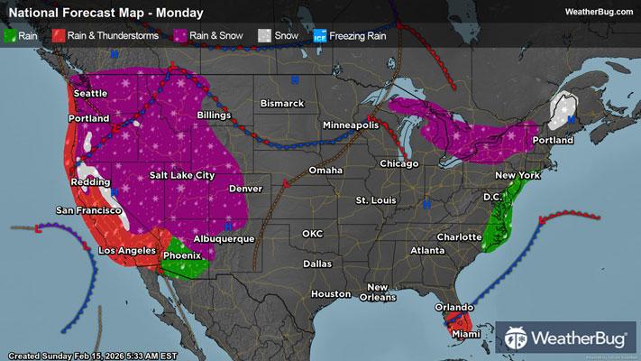
A deep upper-level storm system has taken form west of the Pacific Coastline today. This will enable a burst of “Pineapple Express” moisture to shove over the Southwest into midday Tuesday. Additional disturbances farther to the north will allow wintry precipitation to mix in across the Northwest into the late week.
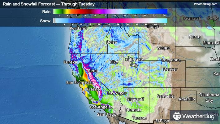
By Wednesday morning, a total of 1 to 2 inches of rain will have fallen across the vast majority of the Pacific coastline, the central Willamette Valley and all but the western slopes of California’s Central Valley. Locally, accumulations of 2 to 4 inches or more will saturate much of California’s midsection. Lesser showers, dropping well below an inch of rain, are expected in lowlands across the Western U.S.
Flood Watches are in effect for southern California, southeast of San Luis Obispo, while Coastal Flood Advisories are posted for most of the San Francisco Bay. The deluge of rain approaching the West Coast brings the threat of both mudslides in the mountains and flooding in urban, low-lying, and coastal areas. Remember, if you see flooded roadways, “Turn Around, Don’t Drown!”
Significant snow additions will pack slopes from the Coastal Range to the Rocky Mountains. In fact, the bullseye of snowfall will bury the Sierra Nevada in walls ranging from 2 to 8 feet or more through Tuesday night! Snow totals of 1 to 2 feet are expected to pile onto ridges along the coastal ranges of northern California, parts of the southern Cascades, the Wasatch Range, the Rocky Front Range, and the Rockies of central Idaho and western Wyoming.
Amounts of 6 to 12 inches will blanket areas farther down these slopes and atop both the northern Cascades and many ridges in the Southwest, while lesser snow peppers the mid-elevations of the Rockies, the Blue Mountains, the coastal ranges of the Northwest, and the Columbia Plateau. Snow elevations will progressively lower west of the Rockies as cold fronts from the storms coalesce and jut eastward.
Winter Storm Warnings, Winter Storm Watches, or Winter Weather Advisories have been issued for most mountainous terrain west of the Great Plains.
Lastly, windy conditions will stretch into even the Great Plains behind the front. High Wind Warnings and Wind Advisories cover areas including southern California, the Klamath Range, elevated areas across the Southwest, the Rocky Front Range, and even the high plains from New Mexico and Texas to southeastern Wyoming and southwestern South Dakota!
Be sure to download the WeatherBug app to stay up to date on the latest on this changing weather. It’s never too early to have a supply kit packed in case of inclement weather. A simple kit including a weather radio, water, blankets, batteries, and non-perishable food items will go a long way in the event of a power outage.