Central U.S. Slammed By Multiple Severe Weather Systems
A pair of low pressure systems will bring severe thunderstorms to the Plains and Midwest through Friday, along with flooding concerns.
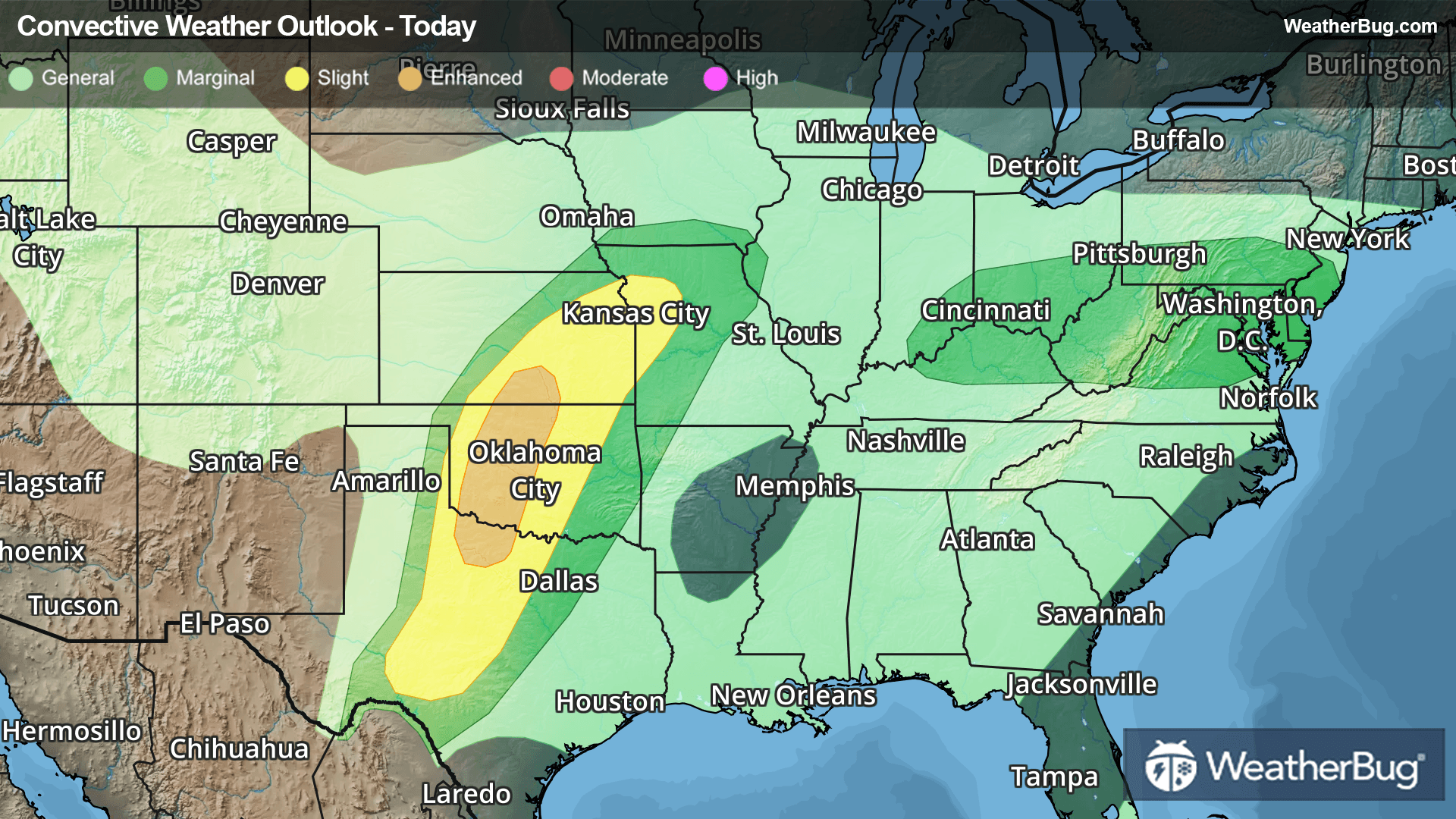
The first disturbance will slide from the Rockies into the central Plains today, providing a classic setup for stormy weather from Texas and Oklahoma up through Kansas and Missouri this afternoon into tonight. Damaging winds, large hail, and several tornadoes will be possible in this region.
The Storm Prediction Center has issued an Enhanced Risk (3 out of 5 on the severe scale) from Wichita Falls, Texas northward into Oklahoma City and Wichita, Kan. A broader Slight Risk (2 out of 5 on the severe scale) includes Abilene, Texas, Tulsa and Woodward, Okla., and Kansas City.
A cold front stalling across the Mid-Atlantic and Ohio Valley will be another focus for storm activity today. Scattered thunderstorms developing from southern Indiana and northern Kentucky to Maryland and southern New Jersey could produce gusty winds and hail this afternoon and evening. A tornado or two cannot be ruled out in the Ohio Valley.
As the central Plains disturbance lifts northeastward, it will target the Midwest with more severe storms on Thursday. There is a Slight Risk in place across parts of Iowa, Illinois, Wisconsin, Michigan, and Indiana. This includes Chicago, Milwaukee, Indianapolis, and Peoria and Springfield, Ill. Strong winds and a few tornadoes will be the main threat, though some pockets of hail are also possible.
On Friday, a developing disturbance will slide in right behind this first storm system. Scattered severe storms will likely develop from the western Midwest into the southern Plains. The best chance for stormy weather stretches from Iowa and northwestern Illinois southward into Missouri, eastern Kansas, and Oklahoma. Damaging winds, large hail, and tornadoes will be possible.
Each day's storms will also be capable of producing localized flash flooding, with rain amounts of 1 to 2 inches possible each day.
Make sure to know the difference between a watch and a warning should they be issued. A "watch" means that conditions are favorable for severe weather to occur, and to be on alert for any rapidly changing conditions. A "warning" means that severe weather is imminent, and you should act fast to remain safe.
The best way to remain safe is to stay prepared and informed about your local weather. Have a severe weather kit packed with a battery-operated radio, water, and non-perishable food items. Also, check the WeatherBug app frequently for any updates on today's severe weather. Remember, "When Thunder Roars, Go Indoors!"