Series of Weather Systems Cover Great Lakes, East in Snow

Two main areas of low pressure will produce snow in Great Lakes region and Eastern U.S.
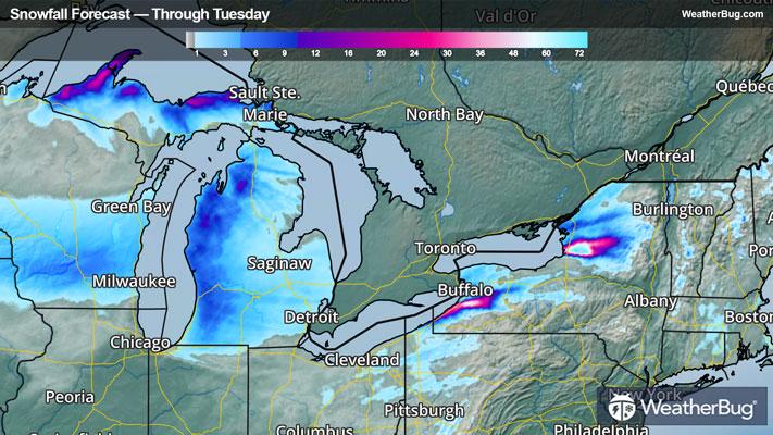
With the atmosphere seemingly stuck in lockjaw, another low pressure system will produce Arctic cold, wind, and snowfall across the Great Lakes today. While the low pressure system itself will only produce 1 to 2 inches of snow in most areas, the cold air will help heavy lake-effect snow bands form across the region into Tuesday. Some areas could approach a foot or more downwind of the lakes by Tuesday afternoon including the Tug Hill region in northern New York, just south of Buffalo in western New York, the Upper Peninsula of Michigan.
Winter Weather Advisories & Winter Storm Warnings are in effect for much of the Great Lakes. There are also Cold Weather Advisories & Extreme Cold Warnings from northern Minnesota to New Jersey, where wind chills could get anywhere from 15 to 35 degrees below zero tonight and Tuesday morning.
Winter Weather Advisories are in place over parts of southern New England as a low pressure system exits the region. An additional inch of snow is possible this morning on top of the 3 to 6 inches of snow that has already occurred. Snow activity should wind down this afternoon.
Hang on to those winter coats, because it doesn't appear the cold and snowy pattern will break anytime soon. The next clipper system could bring a light snow accumulation to Great Lakes on Wednesday.
Be sure to download the WeatherBug app to stay up to date on this changing weather. It’s never too early to have a supply kit packed in case of inclement weather. A simple kit including a weather radio, water, blankets, batteries, and non-perishable food items will go a long way in the event of a power outage.