Back to forecast
Cloud Week: Unusual Clouds
November 3, 2020 at 06:27 PM EST
By WeatherBug's Brandon Bush
Clouds come in many shapes, sizes and types. Some are easier to recognize than others, but there are a few that are much rarer and take a bit of planning to catch.
Most cloud gazers and folks interested in weather will know the main cloud types. The low-level stratus clouds often lead to overcast days where the sun is blocked out. The mid-level cumulous clouds are the most widely recognized as the puffy clouds seen during calm weather. The clouds that often reside at the upper levels of the atmosphere are the cirrus clouds and are wispy, sheet or string-like clouds. These clouds represent the most common types.
Here’s a list of the more elusive clouds and how you can find them:
Searching for rare clouds such as these can start an exciting venture for new and veteran cloud gazers alike!
Most cloud gazers and folks interested in weather will know the main cloud types. The low-level stratus clouds often lead to overcast days where the sun is blocked out. The mid-level cumulous clouds are the most widely recognized as the puffy clouds seen during calm weather. The clouds that often reside at the upper levels of the atmosphere are the cirrus clouds and are wispy, sheet or string-like clouds. These clouds represent the most common types.
Here’s a list of the more elusive clouds and how you can find them:
- Lenticular clouds are large, lens-shaped clouds oriented in either a bulbous vertical direction or a flat saucer shape. These clouds usually appear on the downwind side of mountains or other obstructions as a result of moist air rising over areas of turbulence created by such obstructions. Clouds of this type are often mistaken for UFOs due to their “flying saucer” shape. The abundance of rising air makes them a joy to find for glider pilots, as they provide a generous amount of lift to keep them in the air.
- Arcus clouds, more commonly known as shelf clouds, usually appear along the leading edge of powerful thunderstorms, especially supercells. They are characterized by their long, horizontal formation and usually appear low to the surface.
- Roll clouds are a rare form of arcus cloud that are distinguished by their tube-like shape and rolling motion. Usually found along coasts, they form inside the crests of atmospheric waves that move in one direction without changing speed or shape. They also appear completely separated from other cloud features and storms. Some common sites to see them are the coasts of California, the English Channel, coastal Australia and Nome, Alaska.
- Mammatus clouds take the form of pouch-like protrusions along the undersides of clouds. They are most often found on the underside of thunderstorm anvil clouds and are associated with severe weather. They differ from most clouds in that they are formed by sinking, cold air and are composed primarily of ice, whereas most clouds are formed from rising, condensing air. One lobe can have a diameter nearly 2 miles around and a group of lobes can extend out over 50 miles.
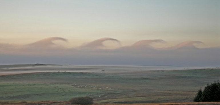
- Kelvin-Helmholtz clouds, also known as billow clouds, are among the rarest of cloud formations. They resemble breaking waves in the ocean, where the wave crest rolls over and spills back into the water. These clouds are formed by an atmospheric phenomenon known as shear, where winds have different speeds at different altitudes. If the winds at higher altitudes are moving faster than those at lower altitudes, the cloud top may get rolled into these wave-like patterns. These clouds can often be seen on windy days and are a good indicator for the presence of turbulence in the air.
Searching for rare clouds such as these can start an exciting venture for new and veteran cloud gazers alike!