Back to forecast
Fall Chill To Persist Across The Eastern U.S.
October 20, 2022 at 06:12 AM EDT
Updated By WeatherBug Meteorologists
A significant fall chill will continue across the southeastern U.S. today, with freezing morning lows possible as far south as Tallahassee, Fla.
Unusually cold air has been brought south across the eastern U.S. this week in the wake of a strong cold front, and although the front is now comfortably offshore the Arctic air it brought will stick around. This cold air will work in tandem with warm waters over the Great Lakes to produce lake effect rain and snow showers in Ohio and upstate New York while the rest of the eastern U.S. enjoys clear, calm weather.
These clear skies will allow low temperatures to reach the low 30s practically everywhere east of the Mississippi River Thursday morning, generally 10 to 20 degrees below average for mid-October, although temperatures in the Florida peninsula may be slightly warmer in the 40s and 50s. The rest of the U.S. will see a mix of 30s and 40s for lows, closer to what’s normal for this time of year.
Freeze Warnings remain issued for a large portion of the Midwest, South and Southeast, including all of Alabama, Mississippi and Tennessee. This includes Louisville, Ky., Indianapolis, Cincinnati, Cleveland, Pittsburg, Virginia Beach, Va., and Atlanta. These warnings are for temperatures dropping below 32 degrees and as low as 26 degrees which could damage crops and outdoor irrigation systems if precautions are not taken to protect them.
Frost Advisories have also been issued for parts of the East Coast, where temperatures will be slightly warmer but still hazardous for uncovered plants. These advisories are in place for Albany, N. Y., Baltimore, Washington, D.C., Columbia, S.C., Savannah, Ga., and Tallahassee and Jacksonville, Fla.
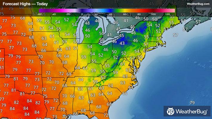
High temperatures today will reach the 50s and 60s for the Northeast, Mid-Atlantic and Midwest, with 60s and 70s for the Southeast and South. The Rocky Mountains will reach the 60s and 70s as well, with 70s and 80s being common west of the Rockies.
Temperatures will rebound to near average on Friday in the eastern U.S. with a very warm day expected for the Great Plains. However, a storm system zipping into the Pacific Northwest will again pull cooler air into the U.S. starting Friday night, and this will spread across the U.S. Saturday through next week Tuesday.
Be sure to dress in plenty of layers to keep warm. Layers of clothing trap body heat and protect skin from cold temperatures and blustery conditions. Protect your ears and hands from the cold and wear protective winter wear.
Unusually cold air has been brought south across the eastern U.S. this week in the wake of a strong cold front, and although the front is now comfortably offshore the Arctic air it brought will stick around. This cold air will work in tandem with warm waters over the Great Lakes to produce lake effect rain and snow showers in Ohio and upstate New York while the rest of the eastern U.S. enjoys clear, calm weather.
These clear skies will allow low temperatures to reach the low 30s practically everywhere east of the Mississippi River Thursday morning, generally 10 to 20 degrees below average for mid-October, although temperatures in the Florida peninsula may be slightly warmer in the 40s and 50s. The rest of the U.S. will see a mix of 30s and 40s for lows, closer to what’s normal for this time of year.
Freeze Warnings remain issued for a large portion of the Midwest, South and Southeast, including all of Alabama, Mississippi and Tennessee. This includes Louisville, Ky., Indianapolis, Cincinnati, Cleveland, Pittsburg, Virginia Beach, Va., and Atlanta. These warnings are for temperatures dropping below 32 degrees and as low as 26 degrees which could damage crops and outdoor irrigation systems if precautions are not taken to protect them.
Frost Advisories have also been issued for parts of the East Coast, where temperatures will be slightly warmer but still hazardous for uncovered plants. These advisories are in place for Albany, N. Y., Baltimore, Washington, D.C., Columbia, S.C., Savannah, Ga., and Tallahassee and Jacksonville, Fla.
High temperatures today will reach the 50s and 60s for the Northeast, Mid-Atlantic and Midwest, with 60s and 70s for the Southeast and South. The Rocky Mountains will reach the 60s and 70s as well, with 70s and 80s being common west of the Rockies.
Temperatures will rebound to near average on Friday in the eastern U.S. with a very warm day expected for the Great Plains. However, a storm system zipping into the Pacific Northwest will again pull cooler air into the U.S. starting Friday night, and this will spread across the U.S. Saturday through next week Tuesday.
Be sure to dress in plenty of layers to keep warm. Layers of clothing trap body heat and protect skin from cold temperatures and blustery conditions. Protect your ears and hands from the cold and wear protective winter wear.