Severe Storms and Flooding Ongoing from the Front Range into the Heartland
Clusters of thunderstorms will continue to produce dangerous hazards across the Central Plains this evening, while areas farther east face a persistent threat of flooding rainfall.
A slow-moving low pressure system over the central U.S. will support the development of severe thunderstorms along and just east of the Front Range this evening. At the same time, a separate system will sustain flash flooding concerns from the Midwest down into portions of the Deep South.
A Severe Thunderstorm Watch is also in effect for portions of central and eastern Kansas. Cities include Emporia, Manhattan, Concordia, and Topeka, Kan.
A Severe Thunderstorm Watch is in effect for portions of northwest Kansas and western and Southwest Nebraska. Cities include Goodland and Hill City, Kan., and North Platte and McCook, Neb.
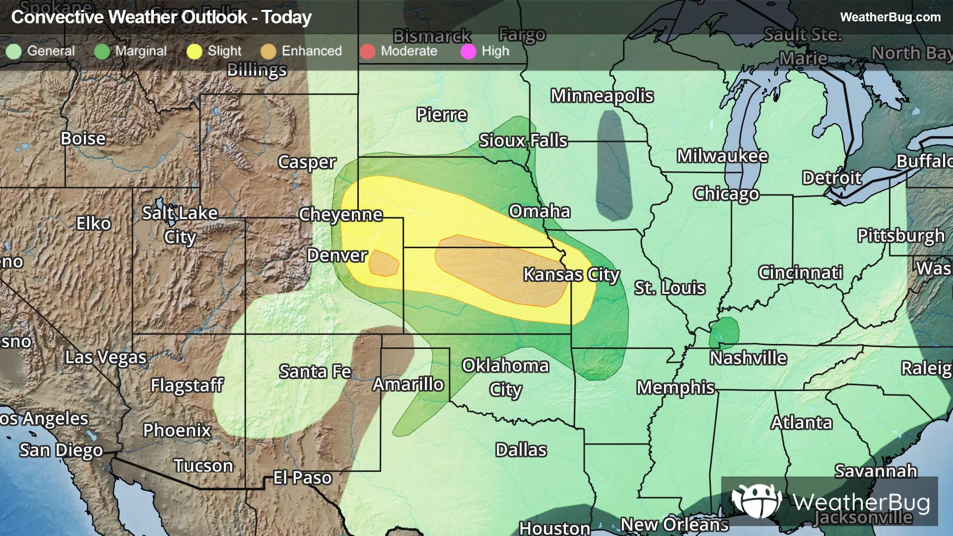
The Storm Prediction Center has highlighted an Enhanced Risk (Level 3 of 5) for a portion of northeast Colorado, along with northeast Kansas, extending into far southern Nebraska. This risk area includes Topeka, Kan. Hazards include very large hail, wind gusts near 70 mph and above, and a few tornadoes.
A Slight Risk (Level 2 of 5) has been issued from southeastern Wyoming and the Colorado Front Range to western Missouri. Cities included are Cheyenne Wyo., McCook, Neb., and Kansas City, Kan. and Mo.
Clusters of storms along the Front Range and over the Central Plains will track into eastern Kansas and western Missouri tonight and early Tuesday morning.
A stalled out front draped across the Midwest along with an upper-level disturbance and moisture will continue to produce flash flooding concerns tonight and Tuesday for the Ozarks, Midwest, Tennessee Valley, and parts of the Deep South.
Flash Flood Watches are in effect from central Kansas to southeastern Iowa and northwestern Illinois southward all the way to northwestern Alabama and northwestern Georgia. A general 2 to 3 inches of rain is expected across this large area but some locations could pick up 5 to 8 inches, especially in the Ozarks.
Make sure to know the difference between a watch and a warning should they be issued. A "watch" means that conditions are favorable for severe weather to occur, and to be on alert for any rapidly changing conditions. A "warning" means that severe weather is imminent, and you should act fast to remain safe.
The best way to remain safe is to stay prepared and informed about your local weather. Have a severe weather kit packed with a battery-operated radio, water, and non-perishable food items. Also, check the WeatherBug app frequently for any updates on today's severe weather. Remember, "When Thunder Roars, Go Indoors!"