Dangerous Storms Target Mid-Atlantic, S. Plains
After several days of severe weather, a menacing cold front continues to trigger dangerous thunderstorms today. The main concerns will be found along the populated I-95 corridor in the Mid-Atlantic and southern New England as well as parts of the southern Plains.
A cold front that has been impacting the eastern two-thirds of the U.S. for the past few days will slowly inch south and east today. This cold front will advance through the Northeast and Mid-Atlantic into the Tennessee and Lower Mississippi valleys and southern Plains. Ahead of this cold front, very warm to hot temperatures and humid air will be in place throughout the East and south-central U.S. Meanwhile, colder, drier air will be found behind the cold front. This collision of air masses will be where thunderstorms fire up throughout the day.
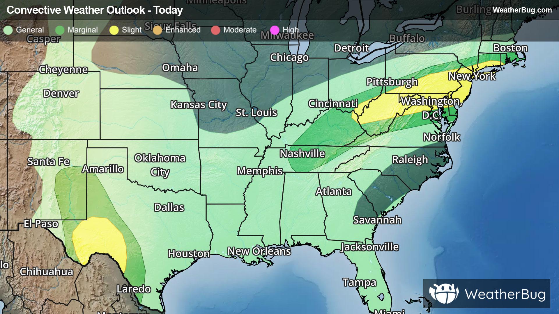
The government’s Storm Prediction Center has issued a Slight Risk, or a 2 out of 5 on the severe storm probability scale, for two areas. The first one stretches from central Appalachia into the Mid-Atlantic and southern New England, while the second covers parts of southwestern Texas. Cities at risk today include the populated corridor of I-95 from Washington, D.C. and Baltimore into Philadelphia and New York City. Charleston, W. Va., and Fort Stockton and Midland, Texas, are also at risk for dangerous thunderstorms today.
Across central Appalachia into the Mid-Atlantic and southern New England, the main threat within thunderstorms will be damaging winds exceeding 60 mph. However, some large hail cannot be ruled out. Then, in southwestern Texas, the main concerns will be destructive winds and large hail. An isolated brief tornado could also be possible.
As if dodging potent storms wasn’t enough, slow-moving, repeated rounds of rain will be likely along this cold front today. Rainfall amounts of 1 to 3 inches could quickly fall, with locally higher amounts possible. With the potential for downpours, localized flooding could become an issue, especially near rivers, creeks and streams as well as urban, low-lying and other flood-prone areas. If you do approach a flooded roadway, remember that it is always best to “Turn Around, Don’t Drown!”
Already, a Flood Watch is in effect for southern Indiana. Additional flood alerts will likely be issued as the day goes on.
After a multiday severe weather outbreak, this cold front finally loses its punch by Thursday. While thunderstorms will be a possibility throughout the Central and Eastern U.S., any chance for severe weather will remain low.
Make sure to know the difference between a watch and a warning should they be issued. A "watch" means that conditions are favorable for severe weather to occur, and to be on alert for any rapidly changing conditions. A "warning" means that severe weather is imminent, and you should act fast to remain safe.
The best way to remain safe is to stay prepared and informed about your local weather. Have a severe weather kit packed with a battery-operated radio, water, and non-perishable food items. Also, check the WeatherBug app frequently for any updates on today's severe weather. Remember, "When Thunder Roars, Go Indoors!"