Dangerous Storms Underway For Northern Plains & Upper Midwest
A strengthening low-pressure system tracking across southern Canada will push a cold front across the north-central United States, creating favorable conditions for severe thunderstorms this evening across parts of the Dakotas, Upper Midwest and Missouri Valley.
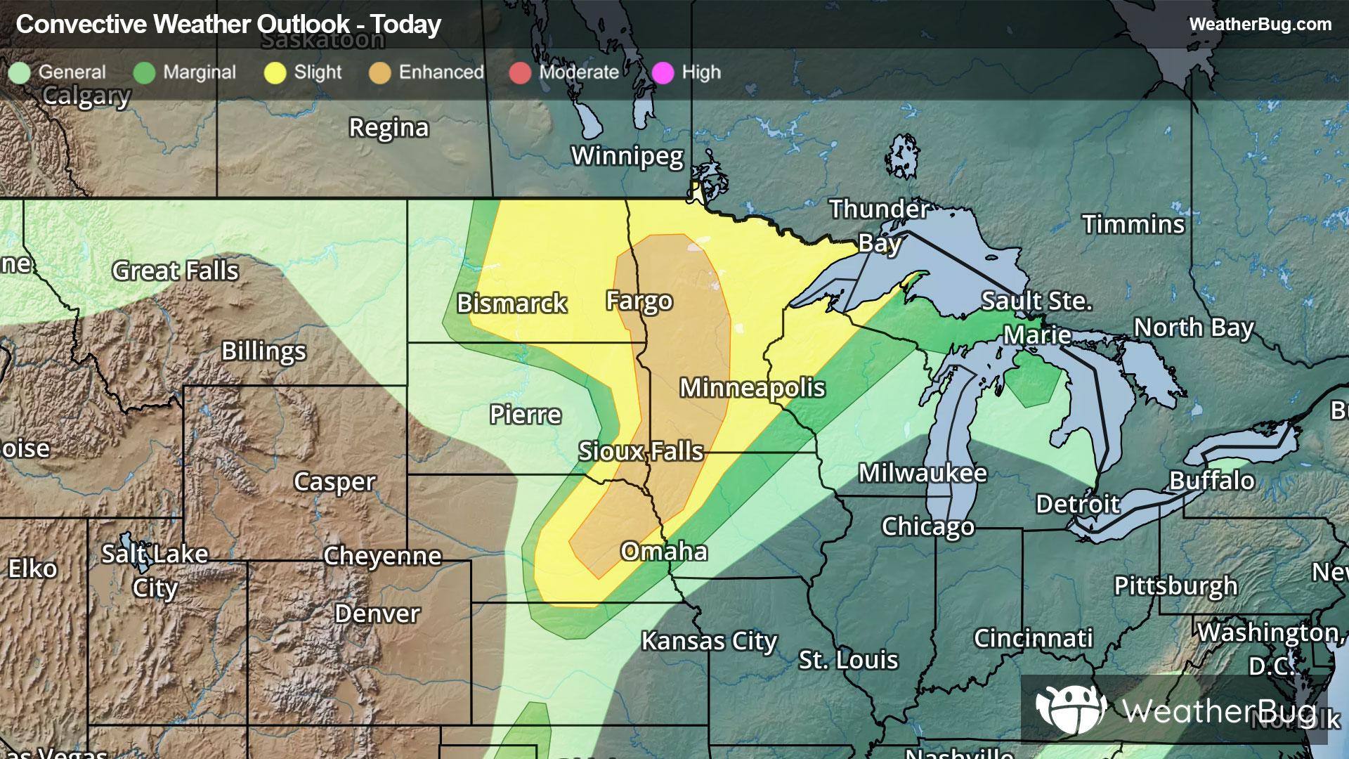
Severe thunderstorms will rumble through parts of the Dakotas, Upper Midwest and Missouri Valley tonight. Storms developing along a cold front in eastern Nebraska are expected to strengthen and spread northeast into portions of South Dakota, Iowa and Minnesota this evening. The atmosphere is highly unstable and favorable for intense storms, with damaging wind gusts potentially exceeding 75 mph. Large to very large hail is also possible, especially with any storms that remain isolated and can strengthen rapidly.
Farther north, from eastern North Dakota into central and western Minnesota, a separate area of severe weather could produce all hazards, including damaging winds, large hail and a few tornadoes. Conditions near a warm front will provide added spin in the atmosphere, increasing the risk for rotating supercells and the potential for a couple of stronger tornadoes through the evening.
The Storm Prediction Center has issued an Enhanced Risk (level 3 of 5) for eastern North Dakota and South Dakota, western Minnesota, northwest Iowa, and northeast Nebraska. Meanwhile, a Slight Risk (level 2 of 5) is in effect for the rest of Minnesota, central North Dakota to eastern South Dakota, northwestern Wisconsin, southern Nebraska, the far western edge of the Upper Peninsula of Michigan, and northwestern Iowa. Cities include Bismarck and Fargo, N.D. Sioux Falls, S.D., and Minneapolis. The main threats are damaging winds, large to very large hail, and even a couple of tornadoes.
A Tornado Watch is in effect for central and eastern North Dakota, northern South Dakota and northwestern Minnesota. A Severe Thunderstorm Watch is also in effect for portions of Upper Michigan, far Northeast Wisconsin, and Lake Superior. A Severe Thunderstorm Watch is in effect for portions of northwest Iowa, central and southwest Minnesota, extreme northeast Nebraska, and eastern South Dakota. A Severe Thunderstorm Watch is in effect for portions of south central into northeast Nebraska. A Tornado Watch is in effect for portions of central and northern Minnesota.
In addition, storms may also produce heavy rain amounts of 1 to 3 inches or more which could cause localized flash flooding. Activity will shift eastward into the Upper Great Lakes on Tuesday.
Make sure to know the difference between a watch and a warning should they be issued. A "watch" means that conditions are favorable for severe weather to occur, and to be on alert for any rapidly changing conditions. A "warning" means that severe weather is imminent, and you should act fast to remain safe.
The best way to remain safe is to stay prepared and informed about your local weather. Have a severe weather kit packed with a battery-operated radio, water, and non-perishable food items. Also, check the WeatherBug app frequently for any updates on today's severe weather. Remember, "When Thunder Roars, Go Indoors!"