Back to Air Quality Alerts
Snowfall to Pack Slopes in the Rockies
December 5, 2025 at 08:20 PM EST
Updated by WeatherBug Meteorologist, Rob Richards
A winter storm is slowly meandering across the Cascades and northern Rockies, packing powdery slopes for avid skiers and headaches for mountain pass commuters through Saturday.
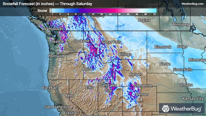
Off of the West Coast, a strong low pressure region to the north and a countering high pressure region to its south will begin to lock in a strong flow of oceanic moisture over the Pacific Northwest and through the Front Range. As a result, many folks in the northern Rockies will observe their first significant snowfall of the season, while those along the coast, on the Columbia Plateau, or in the low intermountain elevations can generally expect a dampened close to the workweek. A few intermountain valleys may be fortunate enough to see light snow amounts, up to 4 inches, mixing into the equation.
Snowfall arrives at Oregon's Cascades and Nevada's northern ranges through the Front Range today as temperatures begin to cool a bit, adding to the snowpile. High winds will pair with the snow today and Saturday as well, enabling blowing snow. Travel will be both slow and dangerous between mountain passes, which could be subject to low-visibility conditions and unmanageable roads.
Winter Storm Warnings/Watches and Winter Weather Advisories are in effect across parts of Idaho, the Cascades of Washington, western Montana, western and southern Wyoming, Utah and western Colorado.
With this storm, it will be the consistency of the snowpack additions that will bury Washington's Cascades and the northern Rocky ridges in powder. Through Saturday, snow totals are expected to surpass 3 to 5 feet for the highest peaks, with totals above 2 feet common for Washington's higher Cascades alongside ridges in northern Idaho into western Montana and Wyoming, Utah's Wasatch Range, and the Colorado Front Range. Totals of 6 to 12 inches will likely stack up for the mid-elevations throughout the northern Rockies, along with Oregon's Cascades.
Be sure to download the WeatherBug app to stay up to date on the latest on this changing weather. It’s never too early to have a supply kit packed in case of inclement weather. A simple kit including a weather radio, water, blankets, batteries, and non-perishable food items will go a long way in the event of a power outage.