Back to forecast
Dangerous Icing Across the Mid-Atlantic, Northeast
February 6, 2025 at 07:23 AM EST
By WeatherBug Meteorologist, Rob Miller
Today, a dangerous mix of ice, sleet, and even snow will disrupt transportation throughout the Mid-Atlantic and Northeast.
An area of low pressure continues to slide along the Mid-Atlantic and Northeast coasts today, sending plenty of cold air southward into the regions. This colder air is colliding with a warm and moist air mass advancing northward, resulting in widespread rain and wintry weather.
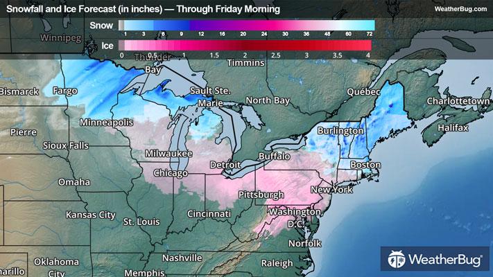
Ice will be the main concern throughout the Mid-Atlantic this morning into the early afternoon hours before temperatures warm above freezing and precipitation comes to an end. Here, ice accretion of 0.15-0.30 inches is likely, while localized ice accumulations can reach upwards of 0.50 inches. This includes cities such as Washington, Baltimore, and Philadelphia.
Ice accretion up to 0.05 to 0.10 inches is likely across southern New England, including around New York, Hartford, Conn., and Boston.
The good news is that temperatures will warm into the 40s in most places this afternoon, allowing the ice to melt away. But with temperatures dropping below freezing later tonight, any wet surfaces have the potential to ice over, especially on elevated surfaces.
Farther north, enough cold air is in place that mainly snow is expected throughout much of the interior Northeast. Even places near the coast will see a period of snow before a transition to sleet and freezing rain, and perhaps even plain rain, occurs this afternoon before all forms of precipitation end later in the afternoon and evening.
When all is said and done, 2 to 5 inches of snow will be common across northern New York into much of central and northern New England. Farther south, an inch or two of snow and sleet is expected across northern New Jersey, southern New York, Connecticut, Rhode Island, and portions of Massachusetts. This includes New York, Albany, N.Y., Hartford, Conn., and Boston.
Winter Weather Advisories remain in place throughout the Mid-Atlantic and Northeast. Cities under these advisories include Pittsburgh, Washington, Baltimore, Philadelphia, New York, Hartford, Conn., Boston, Burlington, Vt., and Portland, Maine.
In addition, Ice Storm Warnings are in place across the Laurel Highlands of southwestern Pennsylvania into the higher elevations of eastern West Virginia, western and central Maryland, and northwestern Virginia. In addition to the snow and ice, the threat of heavy rain has prompted Flood Watches across West Virginia and eastern Kentucky, where rain amounts of 1 to 2 inches are expected.
An area of low pressure continues to slide along the Mid-Atlantic and Northeast coasts today, sending plenty of cold air southward into the regions. This colder air is colliding with a warm and moist air mass advancing northward, resulting in widespread rain and wintry weather.
Ice will be the main concern throughout the Mid-Atlantic this morning into the early afternoon hours before temperatures warm above freezing and precipitation comes to an end. Here, ice accretion of 0.15-0.30 inches is likely, while localized ice accumulations can reach upwards of 0.50 inches. This includes cities such as Washington, Baltimore, and Philadelphia.
Ice accretion up to 0.05 to 0.10 inches is likely across southern New England, including around New York, Hartford, Conn., and Boston.
The good news is that temperatures will warm into the 40s in most places this afternoon, allowing the ice to melt away. But with temperatures dropping below freezing later tonight, any wet surfaces have the potential to ice over, especially on elevated surfaces.
Farther north, enough cold air is in place that mainly snow is expected throughout much of the interior Northeast. Even places near the coast will see a period of snow before a transition to sleet and freezing rain, and perhaps even plain rain, occurs this afternoon before all forms of precipitation end later in the afternoon and evening.
When all is said and done, 2 to 5 inches of snow will be common across northern New York into much of central and northern New England. Farther south, an inch or two of snow and sleet is expected across northern New Jersey, southern New York, Connecticut, Rhode Island, and portions of Massachusetts. This includes New York, Albany, N.Y., Hartford, Conn., and Boston.
Winter Weather Advisories remain in place throughout the Mid-Atlantic and Northeast. Cities under these advisories include Pittsburgh, Washington, Baltimore, Philadelphia, New York, Hartford, Conn., Boston, Burlington, Vt., and Portland, Maine.
In addition, Ice Storm Warnings are in place across the Laurel Highlands of southwestern Pennsylvania into the higher elevations of eastern West Virginia, western and central Maryland, and northwestern Virginia. In addition to the snow and ice, the threat of heavy rain has prompted Flood Watches across West Virginia and eastern Kentucky, where rain amounts of 1 to 2 inches are expected.