Unusual Cold, Lake-Effect Snow Dominate East, South
A winter preview will pack locally heavy snow and unusually cold weather across much of the Eastern and Southern U.S. through Tuesday.
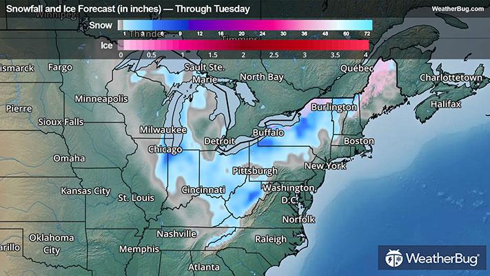
An intensifying area of low pressure will accelerate across Maine and into eastern Canada tonight and Tuesday. Behind it, cold, Canadian air has rushed as far south as the Gulf Coast and much of the Sunshine State. Pesky bands of lake-effect and upslope snow have also dotted parts of the Great Lakes and central and southern Appalachia, which should diminish by Tuesday afternoon or evening.
Winter Storm Warnings and Winter Weather Advisories remain in effect for the eastern Lake Michigan shores from northern Indiana to western Michigan until Tuesday morning. An additional 2 to 5 inches will fall locally in more intense lake-effect banding, with hazardous travel expected along parts of Interstates 80 and 90.
Farther south along the western Appalachia slopes from West Virginia into western North Carolina and northeastern Tennessee, an additional inch to locally 5 to 9 inches of snow will combine with windy weather through early Tuesday. Travel could be difficult, especially overnight with gusts up to 45 mph possible. These gusts could lead to down tree branches. Winter Storm Warnings and Winter Weather Advisories remain in effect, including Elkins and Snowshoe, W. Va., and Bristol and Knoxville, Tenn.
Meanwhile, oscillating, finger-like intense bands of lake-effect snow will persist in parts of the eastern Great Lakes tonight before slowly fading away on Tuesday afternoon. Additional snowfall totals ranging from 2 to 10 inches will be commonplace. Cities such as Ashtabula, Ohio, Erie, Pa., and Jamestown, Rochester, and Syracuse, N.Y., will be brushing away or digging out from the season’s first notable snow event. Lake-Effect Snow Warnings and Winter Weather Advisories are in effect here.
Even worse, the snow will be blown about by gusty winds, which will create near whiteout conditions, downed tree branches, and scattered power outages. Travel will be challenging along parts of Interstate 80, 90, and 94.
So far, this winter blast has deposited impressive snowfall totals around the southern parts of Lake Michigan into the Lower Great Lakes and Ohio Valley. Cedar Lake, Ind., measured 12.3 inches of snow, with 13 inches blanketing Hesston, Ind. Six to 10 inches fell across South Bend., Ind., with an impressive 11.2 inches covering Pleasant Prairie, Wis. Farther east near and south of Interstate 90 in northern Ohio, 2 to 5 inches accumulated between Akron and Cleveland.
Unusually cold weather is part of the storm’s makeup. An extended period of widespread sub-freezing temperatures will greet residents from the Deep South and Gulf Coast to the Mid-Atlantic beaches on Tuesday morning. Upper teens to middle and upper 20s will be a consistent theme to begin the day. Even Florida won’t escape unscathed as wind chills will bottom out in the lower 20s to middle to upper 30s on Tuesday morning. Plumbing that is left unprotected could freeze or sustain damage, while crops and sensitive vegetation may be damaged or killed.
Freeze Warnings and Cold Weather Advisories are in effect from the Texas and Louisiana Gulf Coat through much of Florida to as far north as southeastern Virginia. New Orleans, Jackson, Miss., Birmingham to Mobile, Ala., Atlanta and Savannah, Ga., Jacksonville, Orlando, and Tampa, Fla., Columbia and Charleston, S.C., Charlotte and Raleigh, N.C., and Richmond and Virginia Beach, Va., are included.
It’s never too early to prepare for inclement weather. Having an emergency kit containing a weather radio, extra batteries, non-perishable food, water, clean clothes, and blankets will help keep your family safe, warm, and protected. Be sure to check the WeatherBug App or your local weather stations to keep informed on the approaching weather.