Extreme Cold Trails Winter Storm East of the Rockies
Anomalous cold will surge frigid wind chills east of the Rockies under a strong Arctic high pressure system behind today's snowstorm in New England.
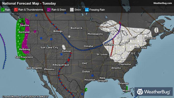
This weekend’s major winter storm is beginning to wind down for most as it tracks into the North Atlantic. Snow will continue to pile up, mainly across Maine as well as eastern Massachusetts. The latter in particular will see the highest storm total snow amounts, reaching up to two feet! These areas, alongside the higher elevations of northern Appalachia, will generally see additions of 2 to 5 inches today, while the central Appalachian spine and few areas downwind of the lakes will catch another 0.5 to 2 inches. Coatings to a half-inch of new snow will be possible today downwind of the Great Lakes, in the rest of central Appalachia, and in the northern Mid-Atlantic through the low-lying interior of New England.
Winter Storm Warnings continue across both Maine and near the eastern shoreline of Lake Ontario, where there is also a Lake Effect Snow Warning.
Across the Coastal South, accumulations of ice will generally begin to thaw. However, a strong supply of cold air that built up ahead of the weekend storm will enable many coatings of snow, sleet, and ice to withstand the daytime highs in the northern Piedmont. Breezy conditions behind the winter storm will also push around the extra icy weight that has built up on trees and power lines, which could lead to additional road closures and power outages.
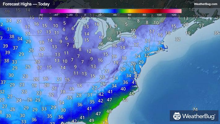
What could be the most impactful after-effect of the storm will be the Arctic air mass currently sagging into the eastern two-thirds of the nation. Areas within the Red River Valley, the Tennessee Valley, the Lower Midwest, and the southern Mid-Atlantic could very well feel their deepest chill of the winter, with many locales’ wind chills dipping to at-or-below the mark of zero degrees Fahrenheit by Tuesday morning. Though wavering, this cold snap is barely expected to budge throughout this coming workweek, and folks without running heat will be especially under threat of this prolonged period of frigid temperatures.
Various cold hazards have been posted across the South, the Lower Midwest, Appalachia, and the Mid-Atlantic, including widespread Extreme Cold Warnings and Cold Weather Advisories. There are also Freeze Watches and Warnings in southern Texas, Georgia, and the northern half of Florida.
Be sure to download the WeatherBug app to stay up to date on this changing weather. It’s never too early to have a supply kit packed in case of inclement weather. A simple kit including a weather radio, water, blankets, batteries, and non-perishable food items will go a long way in the event of a power outage.