Back to Air Quality Alerts
First Snow of the Season In Store for Parts of the East
December 5, 2025 at 12:17 PM EST
By WeatherBug Meteorologist, Alyssa Robinette
The first winter storm of the season is occuring for parts of the southern Mid-Atlantic and Carolinas. Slippery conditions have been reported this morning are likely to continue today given snow and freezing rain. The wintry portion of the system will weaken throughout the afternoon and will be out of the Mid-Atlantic by tonight.
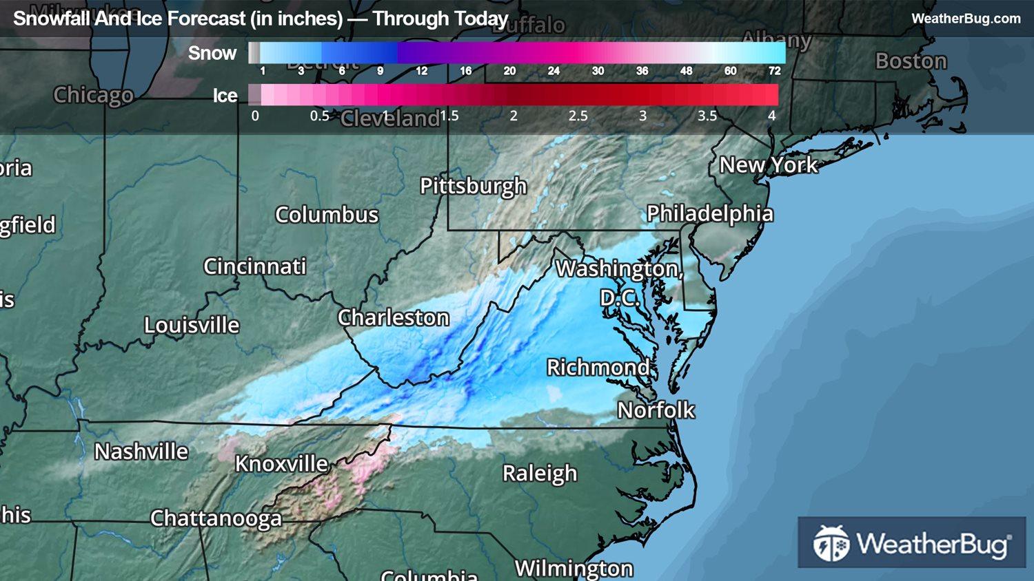
A low pressure system will move along a cold front stalled over the Southeast this morning. There will be a good surge of moisture into the Southeast and southern Mid-Atlantic, which will clash with bitter cold air settling in from the north. The result will be a wintry mess across eastern Kentucky and Tennessee as well as western North Carolina, while snow falls in West Virginia, Virginia, Maryland and the Delmarva Peninsula. Rain will fall across the rest of the Southeast.
This wintry precipitation will spread east this morning. It will then taper off around late morning or early afternoon, with all wintry precipitation ending in the afternoon. Rounds of rain, however, will persist across the Southeast for the rest of the day.
When all is said and done, the heaviest snowfall accumulations will occur in southern West Virginia and western Virginia. Here, snowfall amounts will range from 2 to 4 inches, but some locally higher amounts of 5 to 6 inches cannot be ruled out. Eastern Kentucky, central West Virginia, northern North Carolina, the rest of Virginia, southern Maryland and the southern Delmarva Peninsula could pick up anywhere from one-half inch up to 2 inches. Expect a coating up to one-half inch elsewhere.
Freezing rain will be possible across central and southern Appalachians. Most places should see a glaze to several hundredths of ice. Though, the highest elevations could end up with one-tenth inch of ice.
Winter Weather Advisories are in effect across southeastern Kentucky, northeastern Tennessee, western and northern North Carolina, all of Virginia, southern to central Maryland and portions of the Delmarva Peninsula.
Given the cold temperatures, snow will likely accumulate on all untreated surfaces. Plan on slippery, hazardous road conditions. If you are traveling during the morning commute, be sure to slow down and use caution.