Back to forecast
Severe Storms Target Southeast and Florida Tonight
March 12, 2022 at 01:10 AM EST
UPDATED By WeatherBug Meteorologist, Molly Robinson
Winter is charging toward the Eastern Seaboard, bringing the potential for severe storms later today across the Southeast and Florida where warm spring air has flooded northward.
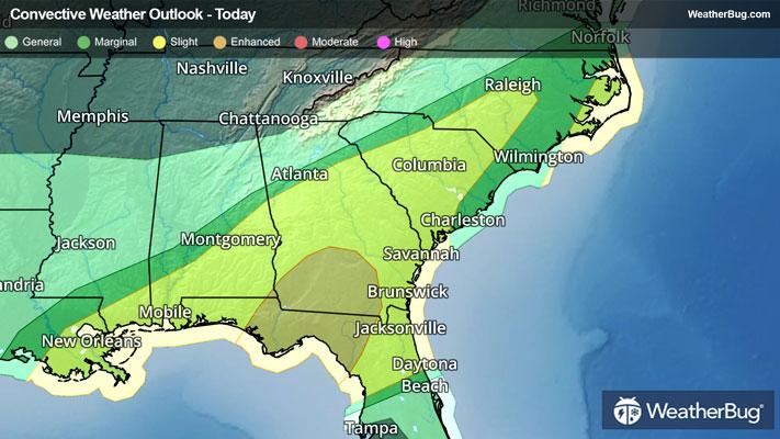
A pesky low pressure system is beginning to form off the Texas Gulf Coast and will accelerate into the Mid-Atlantic by Saturday morning. Warm air and Gulf moisture being sucked into the Southeast while clashing with an arctic cold front pushing toward the Eastern U.S., will fuel severe thunderstorms tonight into Saturday morning. The Florida Panhandle and southern Georgia will see the most action, with the Storm Prediction Center agreeing with this target area for an Enhanced Risk of severe thunderstorms. The primary threat is wind gusts exceeding 60 mph and isolated tornadoes.
While heavy rain continues to traverse northern Florida, no Severe Thunderstorm Watches have been issued. However, Tornado Watches have been issued for the Florida Panhandle, including Panama City and Tallahassee as well as southwestern Georgia, including Albany, Valdosta and Americus until this morning.
These cities as well as Thomasville, Ga., will need to remain storm-aware tonight for these dangerous storms. Residents in Columbia, S.C., Raleigh, N.C., Columbus, Ga., and Jacksonville, Fla. will also need to be storm-aware tonight.
March is climatologically the peak season for severe thunderstorm across Florida and the Deep South. Until this week, the storm threat has been somewhat limited here, with a stark increase in storm activity across the Central U.S., including an EF-4 tornado just last weekend in Iowa.
Understand the difference between a watch and a warning. A watch means conditions are highly favorable for dangerous weather, and you should have a plan in place for acting. A warning means that dangerous weather has been observed, and you need to act quickly to protect life and property. Make sure to remember the phrase, "When Thunder Roars, Go Indoors!"