Back to forecast
Lake-Effect Snow Storm Begins To Wind Down
December 2, 2024 at 07:05 PM EST
UPDATED by WeatherBug Meteorologist, Rob Richards
Several feet of snow has fallen over the past few days, with some areas getting another foot of snow through Tuesday. However, shifting winds will bring the heaviest snow to different areas to start the work week.
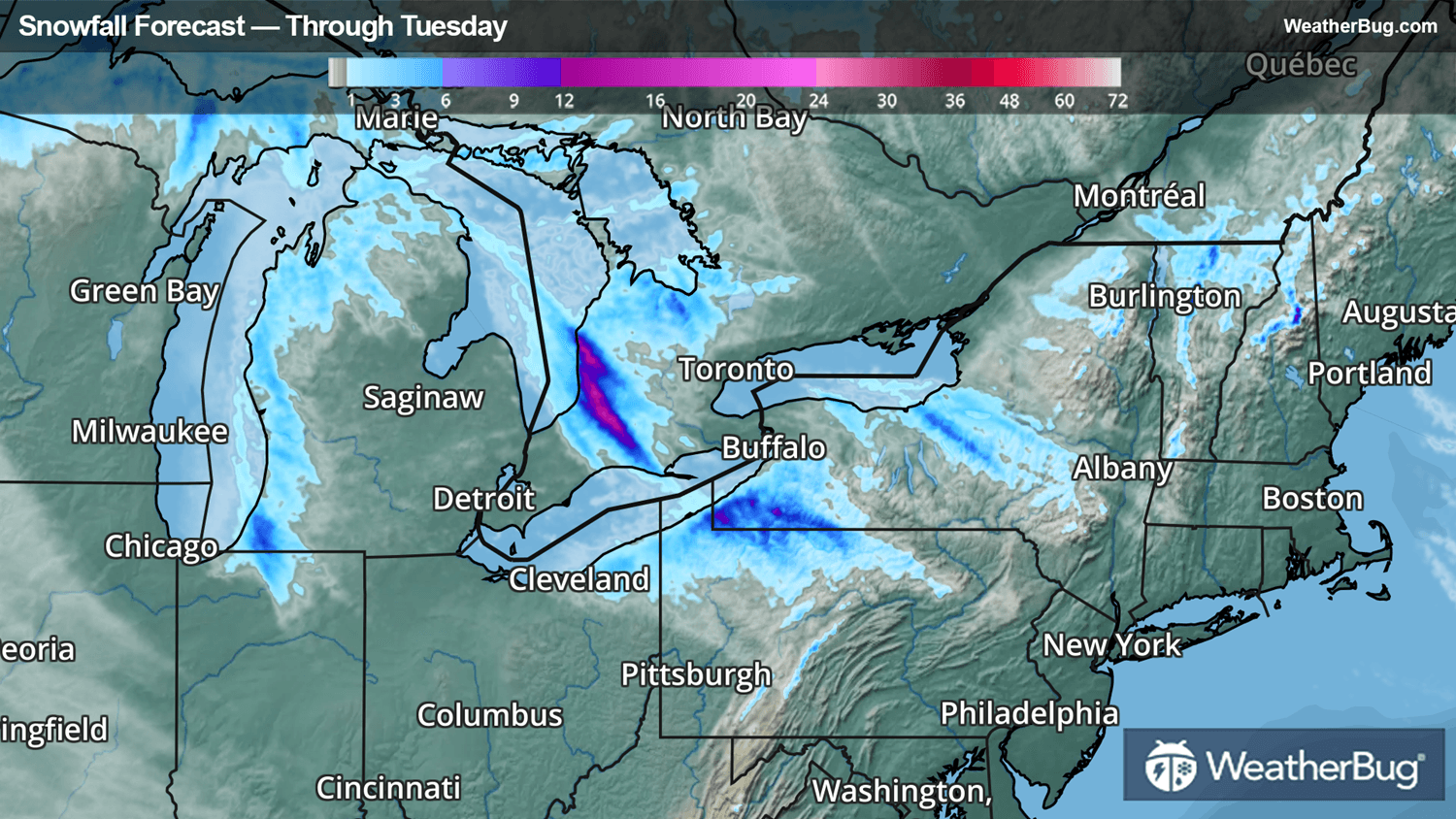
Bitterly cold air continues to flow over the relatively warm waters of the Great Lakes. The result will be bands of moderate to heavy snow today downwind of Lakes Erie and Ontario.
Along Lake Erie, the area most at risk is the snow belt along Interstate 90 between Ashtabula, Ohio, and Dunkirk, N.Y., including Erie, Pa. Repetitive and stubborn bands of lake-effect snow will lead to additional snowfall of 6 to 18 inches of accumulation, with localized amounts up to two feet possible.
Further to the east along Lake Ontario, a wind shift will allow the bands of snow to drift further south tonight into Tuesday. As a result, the heaviest snow will work across I-90 in central New York, including Syracuse. This region will see 4 to 12 inches of snow through Tuesday evening.
A Lake Effect Snow Warning remains in place along the I-90 and I-86 corridors across southwestern New York, northwestern Pennsylvania, and northeastern Ohio. There is a Winter Weather Advisory for the snow falling across central New York.
The same cold air will also be responsible for the lake-effect snow across portions of northern and western Michigan. Winter Storm Warnings and Advisories are found throughout the western parts of Lower Michigan and much of the Upper Peninsula, as well as across far northern Wisconsin. Additional snowfall of 4 to 12 inches will hit these areas through Tuesday.
This is the time to check on the elderly, keep pets inside, dress in as many layers as possible to avoid hypothermia, and have an emergency kit on hand in your car for travels. The best way to remain safe is to stay prepared and informed about your local weather. Have a severe weather kit packed with a battery-operated radio, water, and non-perishable food items should you be without power for long periods.