Back to forecast
Heavy Rain And Snow Return To The Western U.S.
December 13, 2024 at 05:37 AM EST
By WeatherBug Meteorologist, Mark Ellinwood
The end of the week features heavy rain and mountain snow, with a focus on northern California.
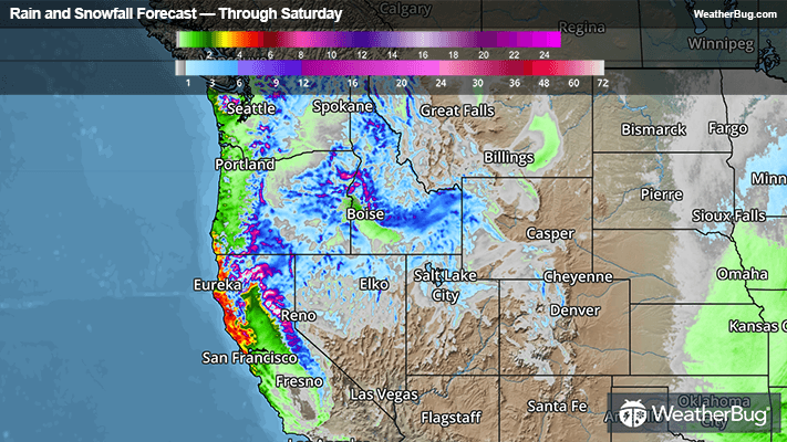
A new winter storm will make its way onto the West Coast this morning and afternoon, and it will gradually advance into the Great Basin on Saturday. Heavy rain will be fairly steady in northwestern California and far southwestern Oregon during this period, with widespread rainfall of 2 to 4 inches likely. Locally higher rain amounts of 4 to 6 inches will also be possible. Flood Watches are up in northwestern California.
Across the higher elevations of northern California and the Sierras, the snow will pile up quickly. Snowfall of 1 to 3 feet will be common in this region, with the highest peaks receiving up to 3 to 4 feet of snow. Winter Storm Warnings are in place to cover the heavy snow.
The snow will still be heavy but less intense across the Cascades, Olympics, and parts of the Great Basin through Saturday. In these regions, the higher elevations will receive 6 to 18 inches of snow, with locally higher amounts up to two feet. There is a smattering of Winter Weather Advisories and Winter Storm Watches to cover this snow threat.
Strong winds will also accompany the rain and snow today through Saturday. Winds Advisories and localized High Wind Warnings can be found in much of northern California and southwestern Oregon. Sustained winds up to 25-35 mph and gusts up to 50 mph will be possible, with some locally higher sustained winds of 35-45 mph and gusts up to 60 mph within the warnings.
If you must travel, keep an extra flashlight, food and water in your vehicle in case of emergency. Be sure to have multiple ways to get the latest weather information from local TV, weather radio, or the WeatherBug app.