Heavy Snow and Icing from Midwest to New England

A major winter storm will arrive with both wintry and windy concerns across the nation's northeastern quadrant through Monday.
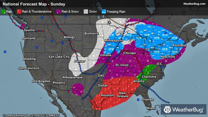
A low pressure system will form just south of the Great Lakes today, shifting across eastern Canada through Monday night. Ahead of its path, a warm front will bring a round of showers in the Lower Midwest today, while strong winds and heavy snow buffet the Upper Midwest behind the storm's cold front. Additionally, even Blizzard Warnings have been posted across parts of central and southern Minnesota and in northern Wisconsin to Michigan’s Upper Peninsula. Mankato and Albert Lee, Minn., and Houghton and Marquette, Mich., are included.
Snow will pile up quickly in the storms north and west in Minnesota, much of Wisconsin, and Michigan’s Upper Peninsula. Rain or a wintry mix, with light ice accumulations, shortly transition to snow, with a range of 4 to 16 inches forecast. Locally, 16 to up to 24 inches are likely, especially near the southern shores of Lake Superior. More general snow blankets of 8 to 16 inches are expected to accrue in areas from east-central Minnesota through northern Wisconsin and parts of western Michigan. An inch or two may accumulate as far south as near Milwaukee, Wis., and southwestern Michigan to far northwestern Maine by early Tuesday morning.
Behind the storm, particularly cold air and northwesterly winds will enable lake-effect snow bands to form across the Great Lakes through a good amount of the workweek. Already, Winter Storm Watches and Warnings associated with forecasted lake-effect snow have been issued in southwestern New York and northwestern Pennsylvania from Monday night to even early Friday morning. Near whiteout conditions and locally more than 7 inches will be possible under the heaviest bands.
Strong, gusty winds will also come to fruition, mainly behind the storm's cold front and especially as the low pressure deepens in strength. Frequent gusts of 45 to 65 mph will thrash about today in much of the Midwest, significantly reducing visibility and leading to power outages. Similar gusts will affect regions such as the northern and eastern Plains, the Middle Mississippi and Ohio valleys, and the Lower Great Lakes both tonight and Monday. Wind Advisories and High Wind Watches are in effect over a vast expanse, which includes the central Plains from the Gulf through North Dakota eastward across the Lower Great Lakes to western New York and the Alleghenies.
In the Northeast, a dam of cold air will briefly sink southward today ahead of the warm front's arrival this evening, setting the stage for a wintry mix. Precipitation will transition to light snow, then sleet, then freezing rain, and finally plain rain through New England, New York, and parts of Pennsylvania, with parts of the northern Mid-Atlantic likely skipping a few steps to just light icing and rainfall. The greatest impact will be thick accretion of ice from Pennsylvania’s Poconos through central New England, bringing major power outages and travel concerns alongside gusty winds. Wind gusts will generally weaken to 45 mph or less for the East Coast states on Monday, with exceptions for higher terrain.
Ice accretions of one-tenth to two-tenths of an inch, and very localized totals of a quarter-inch or just above, will be possible from parts of northwestern Pennsylvania through central Maine. More higher-end localized totals are possible for parts of Interstate 87 in eastern New York around Saratoga Springs, as well as along Interstates 91 and 93 north of Concord, N.H., to just southeast of Montpelier, Vt. Travel should be avoided during late Sunday through Monday in particular. Icing less than a tenth of an inch will glaze most coastal areas north of New Jersey in the Northeast.
Winter Storm Warnings and Winter Weather Advisories, in addition to Winter Storm Watches, are in effect from far eastern Nebraska, Iowa, and Minnesota into the Great Lakes, New York State, taller northeastern Pennsylvania terrain, and much of New England. This includes the Twin Cities and Duluth, Minn., Omaha, Neb., Green Bay, Wis., Gaylord, Mich., Scranton, Pa., Albany, Poughkeepsie, and Utica, N.Y., Hartford, Conn., Worcester and Springfield, Mass., Manchester and Concord, N.H., Burlington, Vt., and Portland to Augusta and Caribou, Maine.
Be sure to download the WeatherBug app to stay up to date on the latest on this changing weather. It is never too early to have a supply kit packed in case of inclement weather. A simple kit including a weather radio, water, blankets, batteries, and non-perishable food items will go a long way in the event of a power outage.