Significant Snowstorm Blankets the Southeast
A coastal storm system forming off the Carolina coastline will cover southern Appalachia to the Outer Banks in snow through Sunday morning before it redirects to the margins of New England.
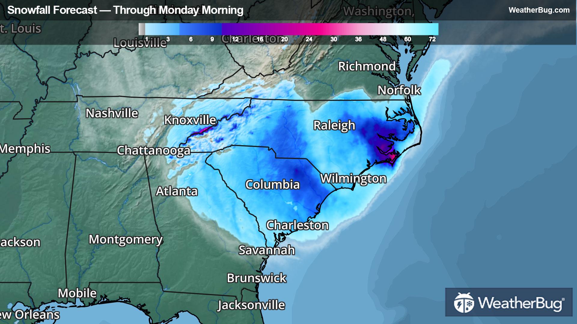
Snowfall will accrue from central Georgia to southern Virginia underneath the tempest, with strengthening rates as the offshore low intensifies. Near-blizzard conditions will buffet the eastern Carolinas at times today through Sunday morning due to the storm’s deep drop in pressure over the Atlantic Ocean, with gusts reaching 40 to 50 mph! Most snowfall will be dry, especially inland, creating a blowing and drifting snow threat. Minor coastal flooding and coastal erosion will also occur across much of the East Coast as a result of the storm's intensity.
The heaviest snow totals will track from southern Appalachia and northern Georgia this morning toward the coasts of the Carolinas and southeastern Virginia on Sunday morning. Expect generalized snow totals of 4 to 7 inches along this path, but coastal and mountainous areas in North Carolina could see localized areas reaching over a foot where the storm’s snow bands set up. Even some rare “bay-effect” enhancement could increase snow totals downwind of the Albemarle and Pamlico Sounds, all thanks to the temperature difference between the air and water! Slightly lower totals are expected in parts of central North Carolina’s north-central Piedmont region.
Winter Storm Warnings and Winter Weather Advisories have been posted from extreme southeastern Kentucky and northern Georgia through southeastern Virginia and the entirety of the Carolinas. Cities under these alerts include Atlanta, Knoxville, Tenn., Roanoke, Richmond, and Virginia Beach, Va., Asheville, Raleigh, and Wilmington, N.C., and Spartanburg, Columbia, and Charleston, S.C.
Luckily for the Northeast, the low pressure system will look to take a northeastward track offshore Sunday through Monday morning, dropping a few flakes along coastal Delmarva and light snow along southeastern Massachusetts. Namely, Cape Cod and Martha’s Vineyard could pack an additional 2 to 5 inches with whipping winds and gusts similar to prior winds in the Outer Banks.
Be sure to download the WeatherBug app to stay up to date on this changing weather. It’s never too early to have a supply kit packed in case of inclement weather. A simple kit including a weather radio, water, blankets, batteries, and non-perishable food items will go a long way in the event of a power outage.