High Winds, Rain, and Snow Cross the Country

With origins in the Pacific Northwest, a clipper storm system moving over the Great Lakes today brings rain, snow, and particularly high winds through the Atlantic Coastline before the weekend begins.
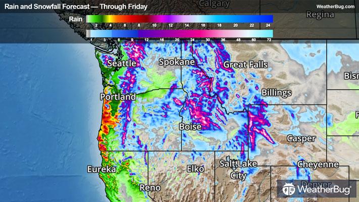
This low pressure system previously battered the Northwest overnight through Wednesday with blizzard conditions in the Cascades, gusts breaking well over 65 mph, deluging rain totals toward the Pacific, and heavy mountain snow. After exiting the Rockies Wednesday night, it will begin to regather itself as it aims eastward.
Rainfall totals start off small across the Midwest through tonight, with up to about an inch in the Lower Ohio River Basin. Snow totals of 2 to 5 inches will pile onto the Canadian border of the northern Plains as well as shores leeward of the Great Lakes in Michigan. Just a coating is expected for other areas near the Great Lakes heading through Friday morning after transitioning to snow overnight.
Wind gusts, however, will be the most dangerous aspect of the clipper. Its rapid jets of wind just above the surface will mix toward the ground both under heavier showers and behind the clipper as high pressure tails it. Rapid gusts from 50 to 75 mph will whip over parts of the north-central Plains today, enabling blizzard conditions through the morning. These winds will lighten into still-high 35 to 45 mph gusts, buffeting locales nearest the Upper Midwest and Great Lakes through early Friday.
The storm amplifies into Friday, where its greatest impacts strike the East Coast and more particularly, the Northeast. Rain totals between 0.5 to 1 inch will be common from coastal Georgia northward in the Southeast, with totals of 1 to 2 inches, and locally up to 2.5 inches, batter the Northeast corridor from the DC Metro to Maine's Canadian border.
Rain shortly turns to snow on Friday behind the clipper's cold front, with 1 to 3 inches of blanketing snow packing onto the central Appalachian spine, the mid-elevations of the Adirondacks, and the Green and White mountains of New England. Totals of 3 to 6 inches will fall east of Lakes Erie and Ontario, enhanced by weak lake effect snow bands.
High winds will still be the main course through Friday in across the East Coast. In Maine and along the Northeast's Atlantic coastline, gusts of 45 to 60 mph or higher are expected, with most impacts Friday morning. A few thunderstorms are also possible nearest the coast Friday morning, which could reel in stronger gusts and create a severe weather threat for the nation's most populous corridor. Threats of impactful gusts will thankfully decrease through the day, albeit slowly.
East of the Rockies, High Wind Warnings are posted across a vast majority of the Great Plains north of Kansas and west of Missouri. Blizzard Warnings cover northeastern Montana through far northwestern Minnesota, while Red Flag Warnings are set for much of Kansas and far eastern Colorado. Wind Advisories and High Wind Watches ahead of the clipper are in place from eastern Kansas through northwestern Missouri, Iowa, and Minnesota.
Wind Advisories are also already posted for most of New York, eastern Pennsylvania, all of New Jersey through Massachusetts, parts of Vermont, and the Appalachian spine down to the Georgia border. High Wind Warnings are also already in effect east of Lakes Erie and Ontario.
Be sure to download the WeatherBug app to stay up to date on the latest on this changing weather. It’s never too early to have a supply kit packed in case of inclement weather. A simple kit including a weather radio, water, blankets, batteries, and non-perishable food items will go a long way in the event of a power outage.