Back to forecast
Hurricane Fernanda Weakens in Pacific
July 19, 2017 at 02:08 AM EDT
UPDATED By WeatherBug Meteorologists, Mike Hertz and James West
The first major hurricane of the Pacific hurricane season is slowly weakening as it churns in the eastern Pacific.
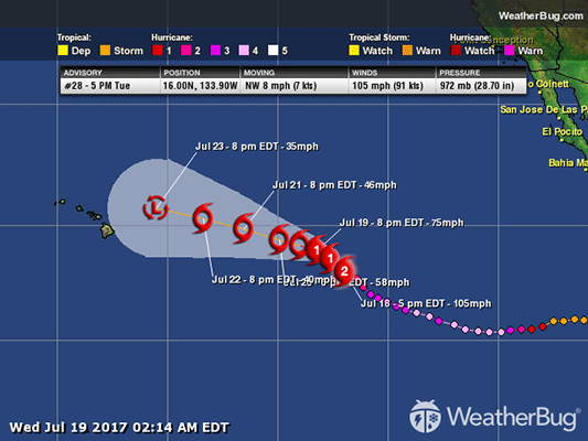
Hurricane Fernanda has weakened to a Category 2 hurricane. As of 8 p.m. PDT, Fernanda is located near 16.5 N and 134.4 W, or about 1,650 miles west-southwest of the southern tip of Baja California and 1,375 miles east of Hilo, Hawaii. Maximum sustained winds have decreased to 100 mph. Although it has weakened from its peak, Fernanda is the first Eastern Pacific hurricane this season to reach category 4 status. Fernanda has a minimum central pressure of 976 mb, or 28.82 inches of mercury, and is moving northwestward at 8 mph.
Hurricane Fernanda is expected to continue to slowly weaken over the next several days as it interacts with cooler sea surface temperatures.
Even though it will not have a direct impact on any landmass, high surf is possible across Mexico and Hawaii through the first half of the week.
Trailing behind Hurricane Fernanda is Tropical Depression Eight-E. If this storm continues to strengthen, the National Hurricane Center will name this storm Hilary. The maximum sustained winds in the tropical depression are 35 mph and it is crawling west at 5 mph.
Following Tropical Depression Eight-E is Tropical Storm Greg moving west at 10 mph. The maximum sustained winds within Greg are 50 mph but this storm is not expected to strengthen much as it moves into cooler waters.
This season started out with Tropical Storm Adrian being named on May 10, which became the earliest known tropical storm in the East Pacific. Only Tropical Storm Beatriz has made landfall this season, causing numerous landslides and mudslides to southwestern Mexico.