Back to forecast
Lake-Effect Snow Machine in High Gear
November 27, 2025 at 10:56 PM EST
By WeatherBug Meteorologist, Rob Miller
An outbreak of cold air will help crank the snow machine to full blast today and Friday downwind of the Great Lakes.
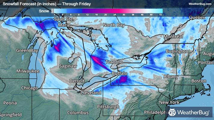
An area of low pressure that produced a streak of 6 to 10 inches of snow across portions of the Dakotas, Minnesota, and northern Minnesota earlier this week will spin over eastern Canada today and Friday. On the west side of this low pressure system, unseasonably cold air will surge southward and move across the still relatively warm waters of the Great Lakes.
This will result in bands of moderate to heavy snowfall in the typical snow belts across Michigan, northern Indiana, Ohio, Pennsylvania, and New York both today and Friday.
Numerous Winter Storm Warnings and Winter Weather Advisories are in effect across Michigan. Cities in Michigan impacted include Marquette, Grand Rapids, and Kalamazoo.
Snow accumulations of 4 to 12 inches will be common, but localized snow amounts of 18 to 24 inches will be possible in areas where snow bands persist the longest.
Farther to the east, widespread Lake-Effect Snow Warnings and Winter Weather Advisories are found across northeastern Ohio, northwestern Pennsylvania, and northern and western New York. This includes cities such as Cleveland, Erie, Pa., and Buffalo and Syracuse, N.Y.
Snow accumulations of 4 to 12 inches will also be common in these snow belts, but localized snow accumulations up to 2 feet will be possible, especially across Ski Country in southwestern New York as well as around the Tug Hill Plateau in northern New York.
In addition to the snow, gusty winds will persist today into Friday. Frequent wind gusts of 25 to 35 mph are expected, with localized wind gusts of 35 to 45 mph near the lakeshore and over the higher elevations, causing blowing and drifting of snow. Wind Advisories are scattered across the Great Lakes into the Appalachian Mountains.
Holiday travel both today and Friday can be impacted by the gusty winds and snow bands. Some interstates that may be impacted include 96, 90, 86, and 80.
Once the lake-effect snow machine winds down Friday night, all eyes will turn to an area of low pressure expected to move across the Plains and toward the Great Lakes from Friday to Sunday. Accompanying this feature will be a swath of moderate to perhaps heavy snow from the northern Rockies into the central Plains and eventually across the Midwest and Great Lakes. In fact, Winter Storm Watches/Warnings and Winter Weather Advisories are in effect across parts of the northern Rockies and northern Plains from northern Idaho and most of Montana eastward to the Dakotas. Winter Storm Watches/Warnings and Winter Weather Advisories have also been issued across much of the Midwest from southern Minnesota and Iowa eastward to west/central Indiana and west-central Ohio.
With wintry weather expected across parts of the U.S. around the Thanksgiving holiday, be sure to have a supply kit packed in case of inclement weather. A simple kit, including a weather radio, water, blankets, batteries and non-perishable food items will go a long way in the event of a power outage or being caught in a winter storm while driving. It’s always best to avoid traveling in rough weather as the roads will be dangerous.