Drought Improves Across U.S. Except in Major Drought-Stricken Areas

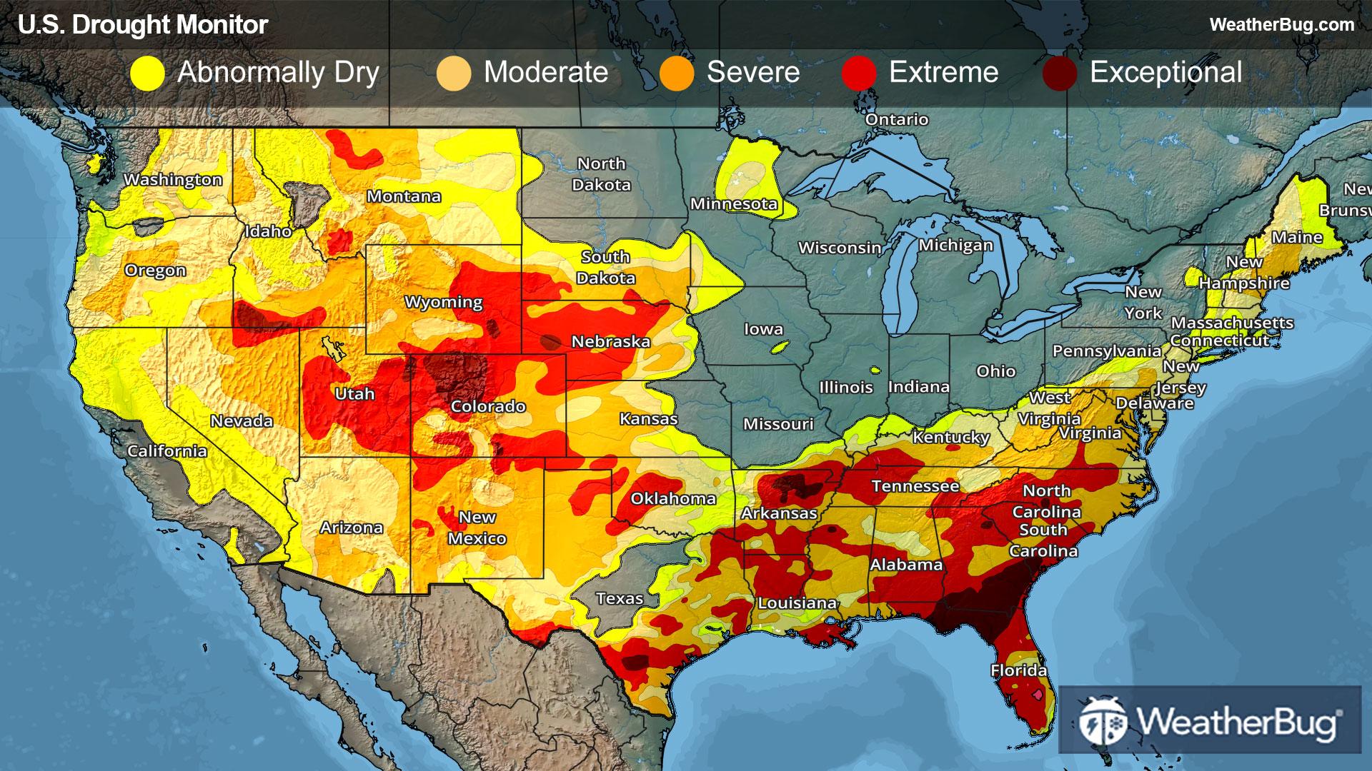
Widespread improvements were made to dryness and drought conditions last week given a very active spring weather pattern. Despite this soggy weather, the drought-stricken areas of the Southwest and South missed out on beneficial moisture.
West
A series of Pacific storms delivered significant rainfall to the lower elevation coastal areas and heavy mountain snow in the Northwest, the northern half of California, the Great Basin and the northern and central Rockies.
In the coast ranges of northern California, 7-day rainfall totals exceed 10+ inches in some areas! This series of storms also provided a late season boost to mountain snowpack levels. The Lake Tahoe area and other parts of the Sierra Nevada picked up 1 to 2+ feet of snow, while areas of the Klamath Mountains saw totals up to 3 feet. Other mountain regions, including the Cascades of Oregon, the Wasatch and Unitas of Utah and the northern Rockies, received amounts of 6 to 24 inches.
In the Southwest, it was largely dry last week, resulting in drought expansion and intensification across Arizona, New Mexico and parts of Colorado. Southwestern Colorado is seeing below normal snowpack levels in the San Juan and Sangre de Cristo ranges, while poor snowpack conditions have also been observed in the mountain ranges of southern Utah, northern Arizona and northern New Mexico.
Central Nevada, northern Utah, northwestern Wyoming and northwestern Colorado saw a reduction in coverage of abnormal dryness and moderate drought (D0-D1) last week. In contrast, extreme drought (D3) expanded in northeastern and south-central Arizona, and extreme drought (D2) expanded in eastern New Mexico. Degradations were made to southwestern and south-central Colorado given the snowpack conditions. An area of severe drought (D2) was also expanded in western Montana.
High Plains
Generally dry weather prevailed across much of the High Plains region last week. However, some areas did pick up some locally beneficial rainfall. The Sand Hills of western Nebraska saw precipitation amounts of 1 to 2 inches over the last week. Consequently, there was a mix of improvements and degradations to the drought depiction this week.
Eastern Wyoming, central Colorado and western Nebraska all saw improvements from abnormal dryness to extreme drought (D0-D3) last week. This includes a small area of extreme drought (D3) being removed from north-central Wyoming, the reduction in coverage of severe to extreme drought (D2-D3) in western Nebraska and the removal of abnormal dryness (D0) for most of central Colorado.
Meanwhile, short-term dry conditions over the past 30 to 60 days led to the expansion of isolated areas of moderate drought (D1) in southwestern and northeastern Kansas.
South
Mainly dry weather occurred across parts of Oklahoma, western Texas, Arkansas and southern Mississippi. Conversely, the Gulf Coast regions of Texas and Louisiana picked up very heavy rainfall (5 to 15+ inches) in some areas. Southern Texas received record-breaking rainfall of 12 inches! The deluge of rainfall led to life-threatening flooding and loss of lives.
The heavy rain allowed for significant improvements in drought-related conditions in southern Texas. Here, there was a reduction in coverage of moderate drought to extreme drought (D1-D3). However, an area of exceptional drought (D4) remains unchanged just north of San Antonio. Beneficial rainfall in Tennessee also led to the removal of moderate drought (D1) in south-central and eastern portions. Abnormal dryness (D0) was also lessened here.
Severe and extreme drought (D2-D3) expanded in parts of western Texas because of the dry weather, and exceptional drought (D4) remains in the Trans-Pecos region. A small area of moderate drought (D1) was also added to northwestern Mississippi.
Midwest
A significant winter and ice storm impacted parts of the Upper Midwest last week. Northeastern Wisconsin and northern Michigan were most impacted, with liquid precipitation amounts of 2 to 4+ inches! Elsewhere, precipitation amounts of 1 to 2 inches were generally seen, though northern Minnesota, northern Illinois and eastern Iowa stayed fairly dry.
An area of severe drought (D2) was removed from northeastern Michigan, while abnormal dryness and moderate drought (D0-D1) were all reduced in southern Minnesota, northern Wisconsin, most of Michigan, northwestern Ohio, central Indiana and northern Missouri.
At the same time, abnormal dryness and moderate drought (D0-D1) expanded in southern Missouri.
Southeast
Light to moderate rainfall occurred throughout most of the Southeast last week, with heavier rain (2 to 4 inches) falling in the Florida Panhandle, southern Florida and northeastern Alabama. Areas that picked up heavier rainfall generally saw improvements to the drought depiction, while other areas saw worsening drought given mounting precipitation deficits.
Moderate to severe drought (D1-D2) saw reductions across central and southern Florida this week. Abnormal dryness (D0) expanded from Virginia and North Carolina to Georgia. Some areas of moderate drought (D1) worsened in southern Georgia, North Carolina and northern Virginia.
Northeast
Generally light rain and snowfall occurred throughout the Northeast region last week. Some areas saw improvement, while other areas saw degradations due to mounting short-term precipitation deficits and low streamflow levels.
Improvements were made to abnormal dryness and moderate drought (D0-D1) in New York, Vermont, New Hampshire, Connecticut, New Jersey and Delaware. This is in response to a combination of factors, including normal to above normal precipitation over the last 30 to 60 days, increased streamflows and some recovery in groundwater levels.
Expansion of abnormal dryness and moderate drought (D0-D1) occurred in Pennsylvania, Maryland and West Virginia.
Looking Ahead (April 1st to April 7th):
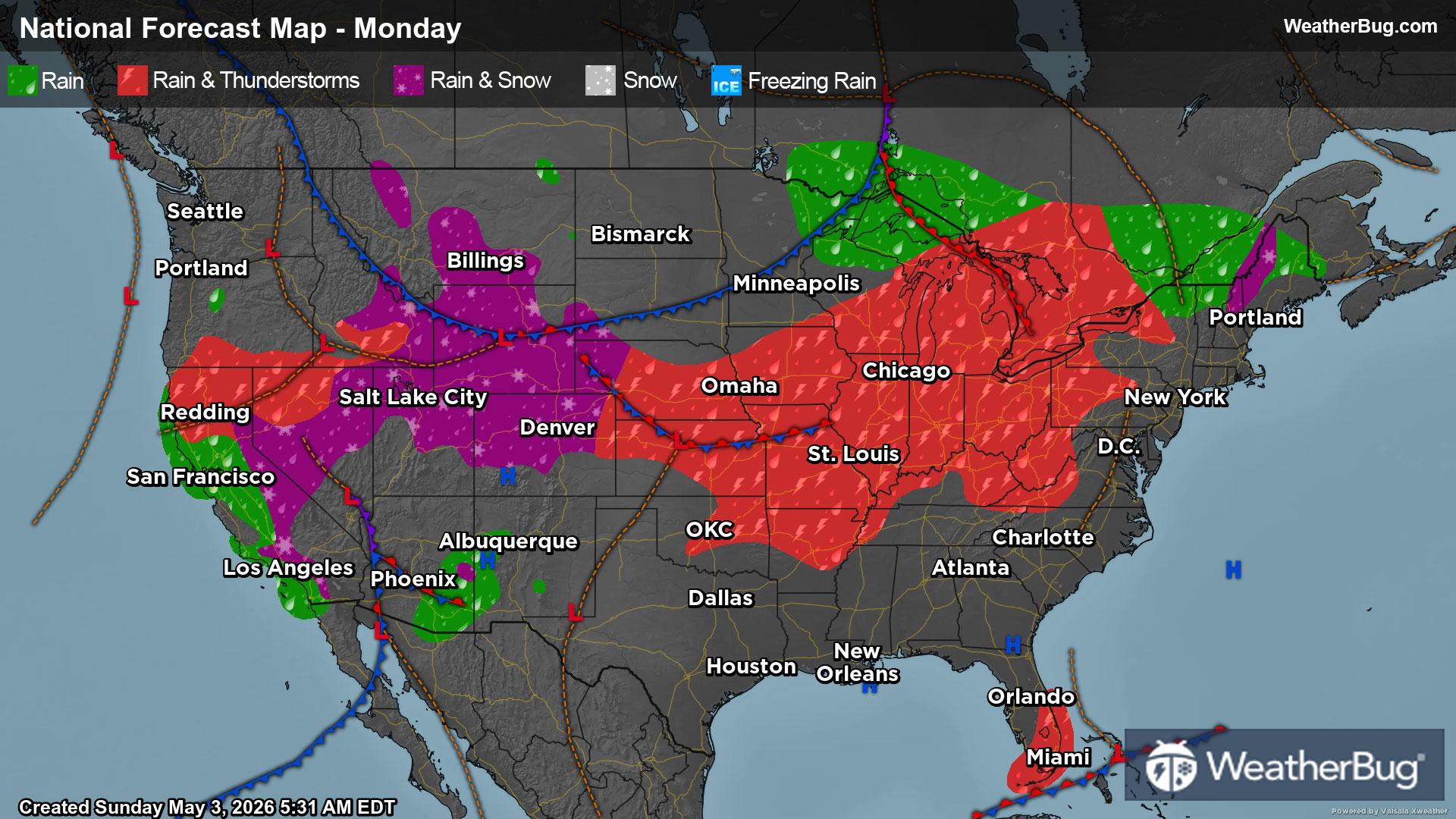
There will continue to be a fairly active weather pattern throughout the U.S. until the end of the weekend thanks to a large upper-level weather system and potent cold front. This weather system and cold front will slowly advance from the Western U.S. into the Eastern U.S. during this time. As a result, most areas will see precipitation.
Expect rain and potential severe weather for parts of the South, Midwest, Southeast and even parts of the Northeast. Heavy to very heavy rain and flooding will be a possibility by the end of the week into the weekend (April 4th through April 6th), especially in the South, Midwest and Southeast.
Snow or mixed wintry precipitation will occur though for the higher elevations of the Mountain West and parts of the Northern Tier.
Things slowly dry out for the central U.S. and Eastern Seaboard by the start of next week. Though, rain and mountain snow will likely continue for parts of the West.
In terms of the drought depiction, widespread improvements will likely occur for the eastern two-thirds of the U.S. given this active weather pattern. Any improvements to dryness and drought look to be more spotty for the West.
------
Source: U.S. Drought Monitor