



Impact of Drought Mixed Across U.S.
Worsening drought grips much of the South and West, while excessive rain brings improvements in the central Plains and Midwest
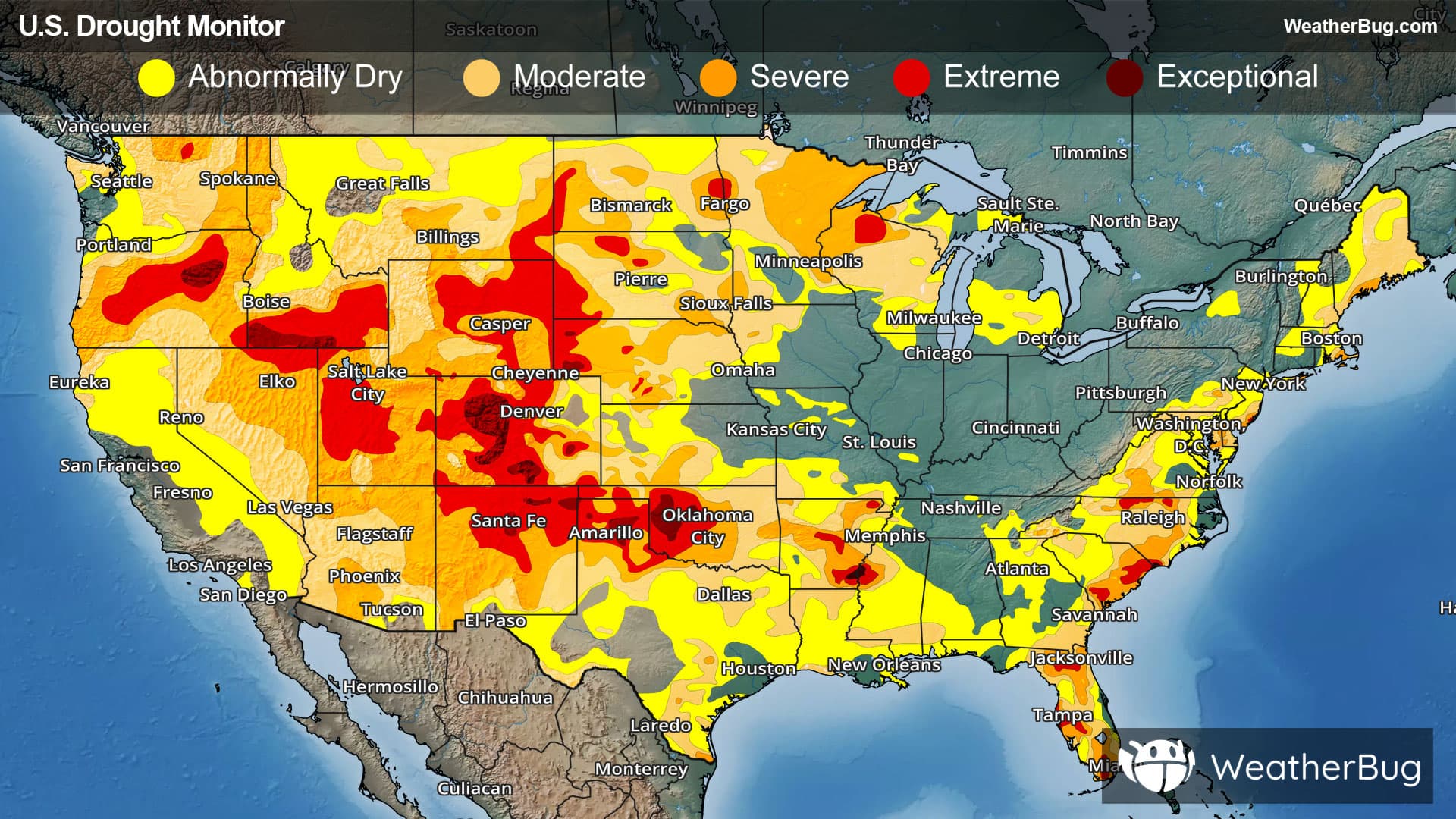
A large band of significant rain occurred during the past week, extending from eastern Nebraska across large parts of Iowa, Illinois, Indiana, Ohio and West Virginia. Over 5 inches of rainfall was observed in central Illinois, central Indiana and central Ohio, leading to scattered areas of flooding. The northern Great Plains states also received 1 to 3 inches over wide areas, as did southeast Wyoming, eastern Colorado, and northwest Kansas. In the Southwest, monsoonal flow continued with scattered storms, providing rainfall amounts generally between 0.5 and 1.5 inches. In contrast, mainly dry weather occurred in the west coast states, the southern Great Plains, the lower Mississippi valley, and in Michigan and most of Wisconsin, with large areas of worsening drought.
West
The western states of California, Oregon, Washington, Nevada, and northern Utah generally received little rainfall. There were small to moderate areas in each of these locations with drought degradations. The vast majority of Oregon is now experiencing some form of drought, and over 60 percent of the state is in severe or extreme (D2 or D3) drought. Eastern New Mexico was warm and dry and had areas of drought degradation, with over 75 percent of New Mexico now in severe or extreme (D2 or D3) drought. Southeastern Montana received little rainfall resulting in a corresponding area of drought degradation. There are areas of extreme drought in Utah, southern Idaho, and in Oregon, with exceptional drought in northeastern Oregon and far southern Idaho. In contrast, areas near the Idaho/Montana border as well as northeastern Montana received enough rainfall to see some improvements. Also, southern Utah and Arizona experienced some monsoonal rainfall leading to small areas of drought improvement.
High Plains
Southern Kansas had some drought degradations from the flash drought warm and dry conditions over the past week. However, eastern Colorado and Wyoming east through Nebraska and northern Kansas received welcome rainfall resulting in drought improvements in these areas. South Dakota was mostly status quo from the past week. North Dakota was mostly dry, leading to degradation in drought. Two areas in the southwest and northwest of North Dakota received some rainfall and drought improvement. Extreme drought (D3) continues to be in place over western South Dakota, western Nebraska, and northeast Wyoming. Colorado is particularly hard-hit, with 49 percent of the state in extreme to exceptional (D3-D4) drought.
Midwest
Widespread and heavy rainfall fell in an area from Iowa across Illinois, Indiana, Ohio, and West Virginia to eastern Kentucky. Eastern Kentucky had a two-category improvement due to heavy rainfall. The rainfall led to removal of all abnormally dry areas in Indiana, Ohio, and Kentucky as well as most of Illinois. There were drought improvements in Iowa, Illinois, and northern Missouri, while southern Missouri had degradation from the warm temperatures and lack of rainfall. Further north, Michigan and Wisconsin had moderate areas of drought degradation with little to no rainfall in the past week. Minnesota had more scattered rainfall, resulting in small areas of both drought improvement and degradation. There is an area of extreme drought in northern Wisconsin.
South
Dryness and drought continued over this region for the past week. All states saw worsening drought conditions. The high pressure over the South resulted in anomalously warm temperatures and almost no precipitation. Flash drought conditions had led to dry ponds and creeks and poor to very poor crop conditions in Texas, Louisiana, Arkansas, and Oklahoma. Drought also deepened over much of southern Mississippi. The only area with drought improvement was eastern Tennessee, where there was significant rainfall. Extreme to exceptional drought conditions continue in western Oklahoma and the Texas Panhandle, as well as southeastern Arkansas.
Southeast
Southern Alabama had wide areas of drought degradation in the southwest part of the state from the warm temperatures and lack of rainfall, shown by flash drought indicators among other metrics. Meanwhile, central Virginia and western North Carolina had drought improvement from the rainfall over the past week. The rest of North Carolina, South Carolina, Georgia, and Florida were mostly status quo for the past week, with only limited areas showing small drought improvements or degradations. There remain some areas of extreme drought in northern North Carolina, coastal South Carolina, and parts of Florida. In the sunshine state, 39 percent of Florida has severe to extreme (D2-D3) drought.
Northeast
Northern Maine, New Hampshire, and Vermont had limited rainfall in the past week, leading to degradations in drought. Deterioration of soil moisture and streamflow were noted in this area. Elsewhere, localized precipitation resulted in small improvement in drought conditions in upstate New York and in central and eastern Massachusetts. Similarly, Maryland, Pennsylvania, and West Virginia had some improvements where there was significant rain during the past week.
Looking Ahead
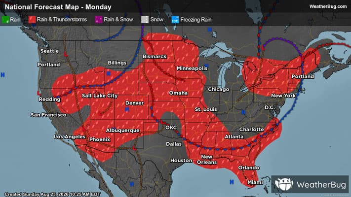
Over the next five days leading up to next Tuesday, above-normal rainfall is possible east of the I-95 corridor along the Atlantic coast. Eastern Indiana, Ohio, and Pennsylvania could also be wet, as well as northern Minnesota and Wisconsin. The area where the Ohio River and Mississippi River meet is also forecast to receive above-normal rainfall. The Southeast should see above-normal rainfall in many locations. The South should continue to have below-normal rainfall, with the Southwestern states having moderate monsoonal rains. The West Coast states are forecast to have little rainfall in the next five days.
The 6- to 10-day outlook (August 25-29, 2026) favors above-normal precipitation across the northern half of the Eastern Seaboard from South Carolina to the eastern Great Lakes region and into New England. Surplus precipitation is also favored throughout Hawaii and over most of mainland Alaska, except for the southern coast, southeast peninsula, and the Aleutian Islands. Below-normal rainfall is favored over much of Texas. Temperatures are likely to be well above-normal over much of the continental U.S. other than the far west coast and the eastern Great Lakes to Mid-Atlantic.