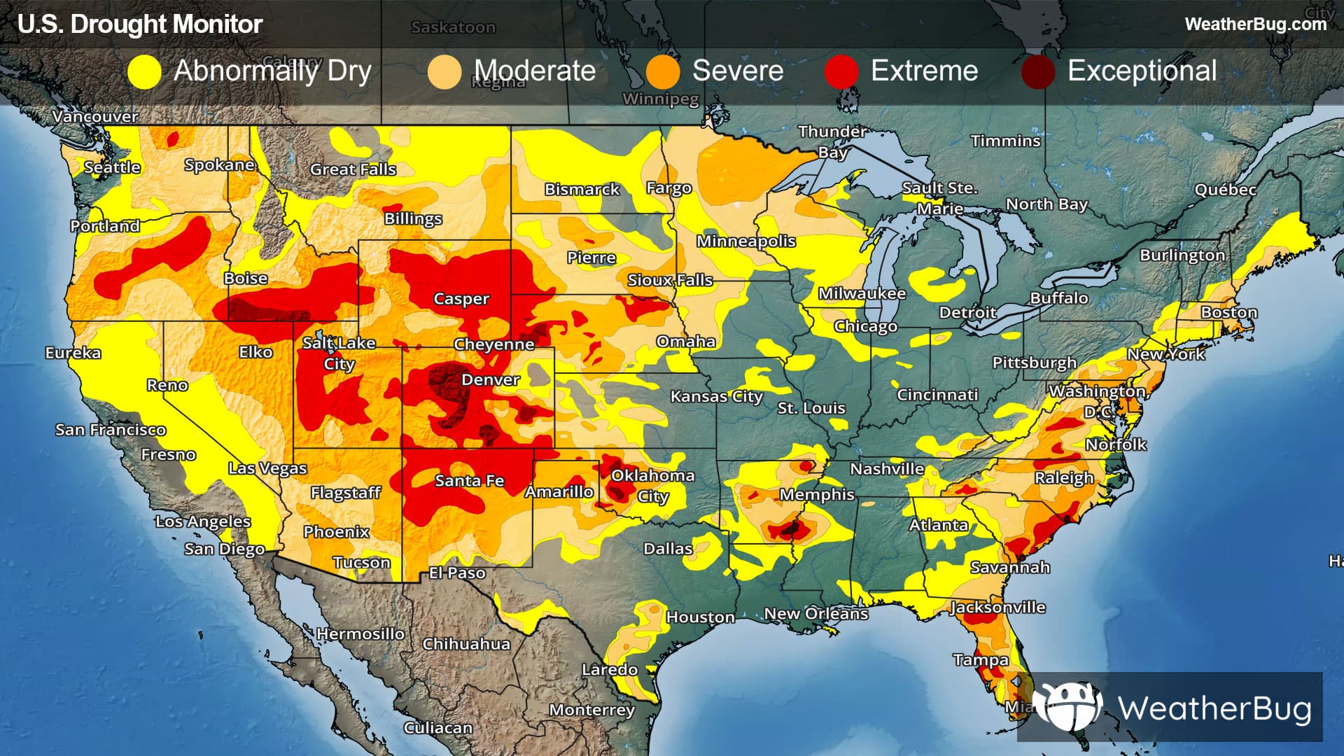
Back to Spark Alerts
Hit-or-Miss Precipitation Leads to Mixed Drought Results
December 12, 2025 at 11:22 AM EST
By WeatherBug Meteorologist, Alyssa Robinette

Soggy, active weather occurred in the drought-stricken areas of the South and Southeast this week, allowing for widespread drought improvements. Significant rain brought drought improvements to the western half of Washington state but also caused widespread flooding. Elsewhere, there was a mix of improvements and degradations to the drought depiction as precipitation was hit-or-miss.
Northeast
An active weather pattern was seen across the Northeast early in the week, thanks to a coastal storm and then a clipper-type system. The coastal storm brought mostly rain to coastal areas, while snow fell elsewhere. Some spotty snow showers were then seen across the entire region with the clipper-type system. Except for some lake-effect snow in areas immediately downwind from the Great Lakes at times, a drier period of weather then occurred for the middle and end of the week.
With temperatures staying cold and below average, precipitation remained largely frozen and unable to benefit the soil. As a result, there were some areas of degradation and a few small improvements.
Degradations were made across central Pennsylvania, southeastern New York and northwestern and eastern New Jersey. This is due to stream-flows running below normal. Severe drought (D2) expanded in northwestern New Jersey, with all other areas seeing abnormal dryness and moderate drought (D0-D1) increase in coverage.
Improvements were made in southeastern West Virginia, southeastern Delaware and central New York. Moderate drought (D1) was removed from southeastern West Virginia, while abnormal dryness (D0) was eliminated in southeastern Delaware. Abnormal dryness and moderate drought contracted slightly in central New York.
Southeast
A cold front was nearly stationary over the Southeast for much of the week, with an upper-level weather disturbance pushing across the region late in the monitoring period. Rounds of rain impacted Alabama, Georgia, northern/central Florida, South Carolina and eastern Carolina throughout much of the period. Rainfall amounts of 2 to 3 inches were observed across southern Alabama and Georgia, the Florida Panhandle, central Florida and along the Carolina coast. Parts of western Virginia and western North Carolina saw two rounds of wintry precipitation, with some light snow and freezing rain. Southern Florida was fairly dry for much of the week until some rain and thunderstorms arrived towards the end of the monitoring period.
Given the soggy, active weather, improvements were made across southern Alabama, southwestern Georgia, the Florida Panhandle, west-central Florida, northeastern South Carolina, eastern North Carolina and northern Virginia. Most notably, exceptional drought (D4) was removed from southwestern Georgia and the Florida Panhandle, with extreme drought (D3) also shrinking considerably. Severe drought (D2) decreased in coverage across southern Alabama and northern Virginia. All other areas saw abnormal dryness and moderate drought (D0-D1) shrink in coverage.
Degradations occurred in northern Alabama, far northern Georgia, the western Carolinas and southern Florida. A small area of moderate drought (D1) was added to western North Carolina, while moderate drought increased in coverage across southern Florida. Abnormal dryness expanded elsewhere.
South
The same cold front that brought beneficial rain to the Southeast also impacted eastern portions of the South last week. Rounds of rain were seen across eastern Texas, southern Arkansas, Louisiana and Mississippi in the first half of the week, where 1.5 to 3 inches of rain fell. Some parts of southern Louisiana even picked up 5 to 6 inches of rain! Western portions of the Southern region were overall drier this week. However, areas of central Texas and the Texas Panhandle did still see improvements this week given the overall active pattern over the last few weeks.
Improvements were seen in far eastern Tennessee, southern Mississippi, southern and northwestern Louisiana, southwestern Arkansas, eastern and central Texas and the Texas Panhandle. Extreme drought (D3) decreased in coverage across southeastern Texas. An area of severe drought (D2) was removed across southern Louisiana, with severe drought decreasing in coverage in southeastern Texas. Moderate drought (D1) was removed in central Texas, with improvements made to abnormal dryness and moderate drought (D0-D1) elsewhere.
Degradations were made in Texas’ southwestern Panhandle, northeastern Oklahoma and south-central and southeastern Tennessee as the lack of precipitation continues to dry out the ground and lead to lower stream-flows. Moderate drought (D1) increased in size across Texas’ southwestern Panhandle, while abnormal dryness (D0) worsened elsewhere.
Midwest
A series of fast-moving weather disturbances impacted the Midwest last week, bringing multiple chances for some light snow. However, given the precipitation fell as snow, this limited its ability to improve soil moisture and stream-flows. Overall drought changes in the Midwest were mixed and localized.
Small improvements were made to northeastern Missouri and west-central Illinois (near the St. Louis metro area). Both areas saw moderate drought (D1) decrease in coverage.
Degradations were made to southeastern Michigan, west-central Indiana, east-central Illinois and northwestern and southeastern Missouri. Moderate to extreme drought (D1-D3) expanded across east-central Illinois, with moderate drought (D1) increasing across southeastern Michigan and west-central Indiana. Abnormal dryness increased in coverage elsewhere.
High Plains
Similar to the Midwest, fast-moving weather disturbances brought some spotty chances for snow to the High Plains region. However, this snow was generally not enough to make up for mounting precipitation deficits for much of the region, and degradations occurred as a result. There was some snow in the Rockies that did help ease some drought and dry conditions.
Improvements were made to west-central Wyoming and central and eastern Colorado. Extreme drought (D3) contracted slightly in central Colorado, with improvements made to severe drought (D2) in west-central Wyoming. Abnormal dryness (D0) improved in eastern Colorado.
Degradations occurred in southeastern Kansas and southeastern Wyoming. Both spots saw an increase in abnormal dryness (D0).
West
Multiple weather systems and the start of an “atmospheric river” allowed for an active weather pattern in the Northwest last week. Rain soaked the coast and lower elevations, which brought liquid precipitation amounts upwards of 6 to 8 inches. Areas with the most precipitation were northern California, western Oregon, Washington, northern Idaho, and western Montana. Snow piled up in the mountains and higher elevations, with parts of western Montana and eastern Idaho seeing 1 to 3 feet of snow! Snowpack throughout the Rocky Mountains is improving, but southwestern Montana and central Idaho are still experiencing below normal snowpack
Meanwhile, dry weather prevailed throughout the Southwest. However, despite no precipitation this week, the recent rain over the past few weeks continues to improve stream-flows and soil moisture.
Improvements were made to northwestern Montana, western and central Washington, southern Nevada, southeastern California and western Arizona. Moderate drought (D1) contracted across northwestern Montana. Moderate to severe drought (D1-D2) improved for western and central Washington. Abnormal dryness and moderate drought (D0-D1) improved across southern Nevada and western Arizona, while abnormal dryness was removed from southeastern California.
Degradations were made to southwestern and central Oregon, northwestern California, southwestern Montana and east-central Nevada. Moderate drought (D1) expanded across southwestern Montana, while abnormal dryness and moderate drought (D0-D1) worsened across southwestern and central Oregon. Abnormal dryness was (D0) added to northwestern California, while moderate to severe drought (D1-D2) worsened for east-central Nevada.
Looking Ahead
The forecast highlights the Pacific Northwest as the region expecting the heaviest precipitation, with coastal Washington, Oregon and far northern California likely to receive over 5 to 10 inches of rain. Moderate precipitation is forecast for the northern Rockies, northern Plains and Upper Midwest, where most areas will see 0.5 to 2 inches, with locally higher amounts in terrain-enhanced zones.
Farther south and east, a broad swath from eastern Texas through the Gulf Coast and into the Carolinas is expected to experience lighter but steady rainfall totaling roughly 0.5 to 2 inches. The Northeast should see similar amounts, generally in the 1 to 2-inch range.
Meanwhile, the Interior West is expected to remain mostly dry, with little to no precipitation forecast. This includes the Great Basin, Southwest and central Rockies.
-----
Source: U.S. Drought Monitor

