
Drought Improves for Much Of the U.S. Thanks to Stormy Weather
Unseasonably warm but stormy, soggy weather prevailed for much of last week throughout the U.S., leading to widespread improvements to abnormally dry and drought conditions. The exception was the West, which stayed both warm and dry.
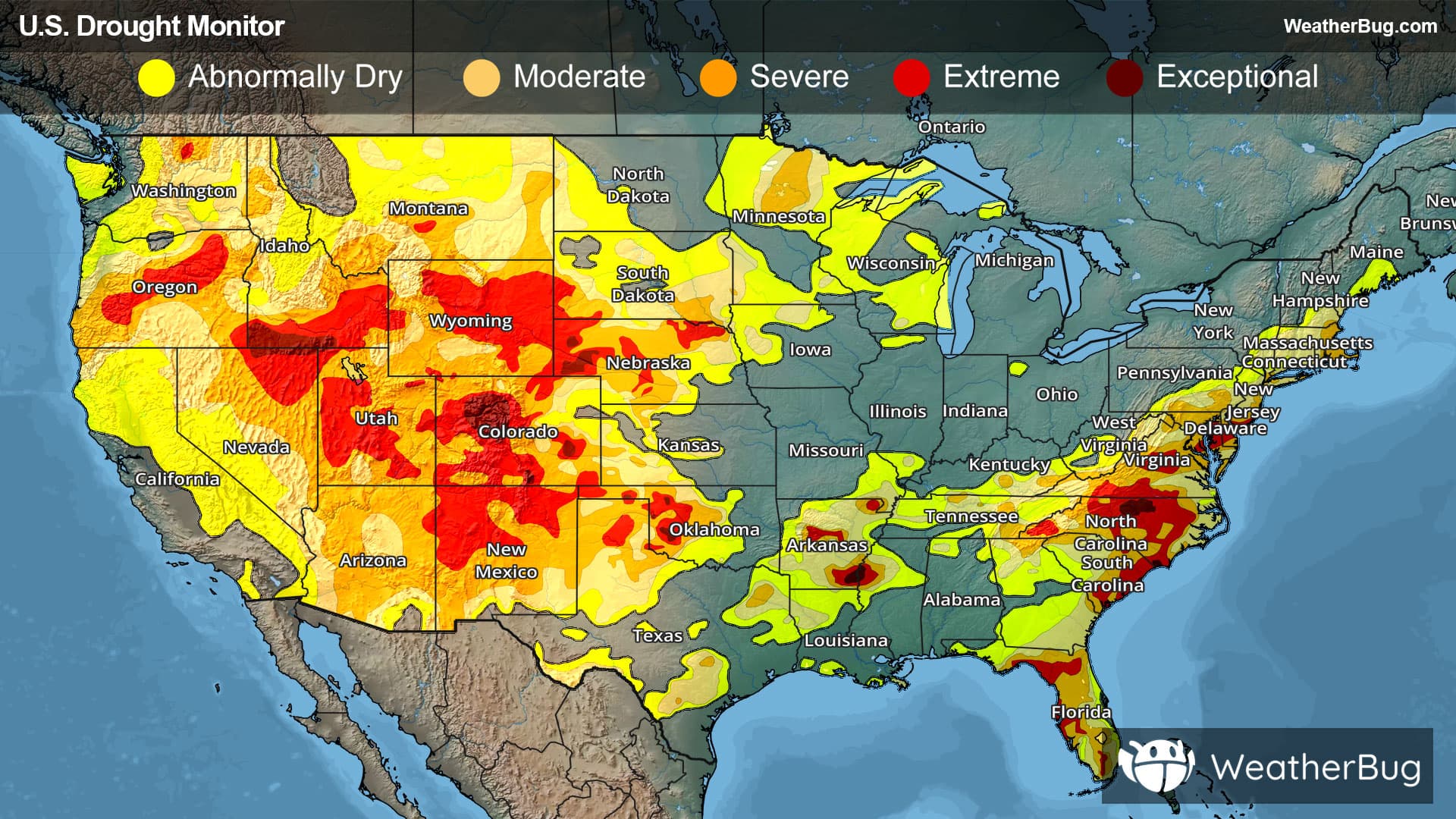
West
With high pressure settled overhead, most of the Western region remained dry over the last week. There were a few exceptions, including rain and thunderstorms along the Idaho-Montana border, parts of southern and eastern Montana, northwestern Washington and in parts of New Mexico. Despite the dry weather, temperatures largely remain near or slightly below normal.
As a result of the dry weather, extreme and exceptional drought (D3-D4) degraded in parts of central and southwestern Colorado, where multiple large wildfires were occurring in areas of low soil moisture and large precipitation deficits. This includes the large Aspen Acres Fire that has burned at least 96,000 acres near Colorado City. This places it seventh on the list of Colorado’s largest wildfires and this fire will likely continue to grow with only little containment.
Degradations also occurred in parts of Oregon and adjacent far northern California and in north-central Washington. In these areas, streamflow level remained low and precipitation deficits at both short- and long-term timescales grew. Water deliveries to properties near Bend, Ore., were shut off this week as water supplies run low. A small area of extreme drought (D3) was added to north-central Washington, with extreme drought also increasing in central Oregon. Severe drought (D2) expanded from southwestern Oregon into northern California. Widespread severe and extreme drought (D2-D3) continues in Oregon, eastern Nevada, Colorado, Wyoming, New Mexico, Utah and southern Idaho.
Conversely, there were some localized improvements to drought conditions in Montana and central Idaho. Two areas of extreme drought (D3) were removed from east-central Montana, while moderate to extreme drought (D1-D3) improved across southwestern Montana into central Idaho.
High Plains
Rain and thunderstorms were hit-or-miss across the High Plains last week. Scattered heavier rain and thunderstorms impacted parts of the Great Plains of northeastern Colorado, the northern half of Kansas, parts of southwest and southeast Nebraska and the Missouri and Big Sioux corridors in South Dakota and northeastern Nebraska. Temperatures throughout the region were mostly near or warmer than normal throughout the week. Given the scattered nature of rain and storms, there was a mix of improvements and degradations to the drought depiction this week.
Deficits in precipitation and soil moisture grew in parts of east-central Nebraska, where abnormal dryness and moderate drought (D0-D1) expanded. North-central and western South Dakota also saw expansion of abnormal dryness and moderate to extreme drought (D0-D3) as short- and long-term precipitation deficits grew amid declining soil moisture and streamflow. Parts of central Colorado saw conditions degrade this week as precipitation deficits grew, especially near and east of Denver and Colorado Springs. This includes an expansion of severe to exceptional drought (D2-D4). Similar conditions were observed in north-central Colorado and south-central and northwestern Wyoming, leading to degradations to severe and extreme drought (D2-D3).
A small area of improvement occurred to moderate to severe drought (D1-D2) in north-central Wyoming, where vegetation conditions improved after recent precipitation. Places that saw heavier rain also reported locally improved drought or abnormally dry conditions. This includes abnormal dryness to moderate drought (D0-D1) in northeastern Colorado; abnormal dryness to severe drought (D0-D2) in western Kansas; extreme to exceptional drought (D3-D4) in western and south-central Nebraska; severe to extreme drought (D2-D3) in northeastern Nebraska; and abnormal dryness and moderate to severe drought (D0-D2) in central South Dakota.
Midwest
While temperatures remained unseasonably warm, the Midwest did some heavier rain over the last week. Rainfall amounts of 2 to 8 inches were seen from portions of central and northern Iowa into southern Minnesota and central and west-central Wisconsin. Heavy rain also fell west of Chicago eastward to southeastern Michigan, where 2 to 6 inches of rain fell. However, most of the rain that fell was in areas already free of drought or abnormal dryness.
Some localized 1- and even 2-category improvements were noted in southeastern Minnesota into west-central Wisconsin, with localized improvements also occurring in northern Illinois. These changes were made to abnormally dry and moderate drought (D0-D1).
At the same time, there were some scattered areas where drought degraded. This includes Minnesota’s Arrowhead, parts of Michigan’s Upper Peninsula, northwestern Ohio and parts of southeastern Missouri into southern Illinois. This includes expansion and introduction of both abnormally dry and moderate drought (D0-D1) conditions.
South
Precipitation varied throughout the South last week, with some areas seeing beneficial rainfall and others staying completely dry. Rainfall amounts over 2 inches fell over parts of southern Arkansas, northern and southern Louisiana, central and western Tennessee, northeastern Texas and a few parts of the Texas Panhandle and western Texas. Temperatures are also near or above normal temperatures covered most of the South this week.
Deficits in soil moisture and precipitation lessened in parts of western Oklahoma, the Texas Panhandle and other areas of western Texas, leading to some improvements in ongoing moderate to severe drought (D2-D3). Likewise, long-term moderate to severe drought (D1-D2) conditions were improved in portions of central Tennessee, aided by rains this week. Recent rainfall also improved soil moisture, streamflow and lessened precipitation shortages across much of northern and southeastern Louisiana and central and southern Arkansas, leading to widespread improvements to abnormal dryness and moderate to exceptional drought (D0-D4). Isolated improvements also occurred in northwestern Mississippi, though conditions across Mississippi were mostly stable as far as drought or dryness.
A small area of severe drought (D2) developed in north-central Tennessee, where precipitation deficits grew and soil moisture dried. New areas of abnormal dryness (D0) were also added to central Texas and southwestern Louisiana.
Southeast
Warmer than normal temperatures occurred in the northern half of the Southeast last week, while the southern half was generally near normal. In terms of rainfall, there were the haves and have-nots throughout the region. Isolated areas of at least 2 inches of rain occurred in parts of east-central Virginia and isolated parts of northern North Carolina. Widespread heavy rain fell across parts of the Florida Peninsula, where there were rainfall amounts in excess of 5 inches.
In the areas of North Carolina and Virginia that received more generous rain amounts, localized improvements occurred as precipitation deficits lessened and soil moisture increased. Heavy rain amounts in the Florida Peninsula alleviated short-term precipitation deficits and locally improved soil moisture and streamflow, leading to a few areas of improvement in ongoing long-term drought. Locally heavy rain in parts of the Florida Panhandle also led to local improvements.
This includes severe and extreme drought (D2-D3) in southeastern Virginia, while exceptional drought (D4) contracted slightly in north-central North Carolina. Abnormal dryness (D0) was removed from southeastern Alabama. Moderate to extreme drought (D1-D3) improved both parts of the Florida Panhandle and Peninsula.
In northern Virginia, northern Georgia and large parts of North Carolina and South Carolina, drier weather occurred amid warmer than normal temperatures. This resulted in widespread degradation in moderate to extreme drought (D1-D3) conditions in areas where soil moisture, streamflow and precipitation deficits in the short- and long-term worsened. Water restrictions and organized conservation efforts were occurring in several locations in Virginia and North Carolina.
Northeast
The Northeast region saw warmer than normal temperatures and soggy, stormy weather for much of last week. Widespread heavy rains fell in New York City area, southern New England, southern New York, eastern Pennsylvania and portions of New Jersey. Rain amounts over 2 inches were common, and some locations recorded 4 to 6 inches. Long-term precipitation deficits and groundwater shortages continued in many areas, so improvements were mostly limited to the areas where rainfall amounts were the heaviest.
Ongoing drought and abnormal dryness improved in parts of eastern Pennsylvania, southern West Virginia, New Jersey, southern New York and a few areas of Connecticut and Rhode Island, where the heaviest rains occurred. This includes improvements to abnormal dryness and moderate to severe drought (D0-D2). Recent precipitation has also improved soil moisture in southern Maine, leading to the removal of moderate drought (D1) there, though the area has not yet caught up with long-term precipitation shortages.
Looking Ahead
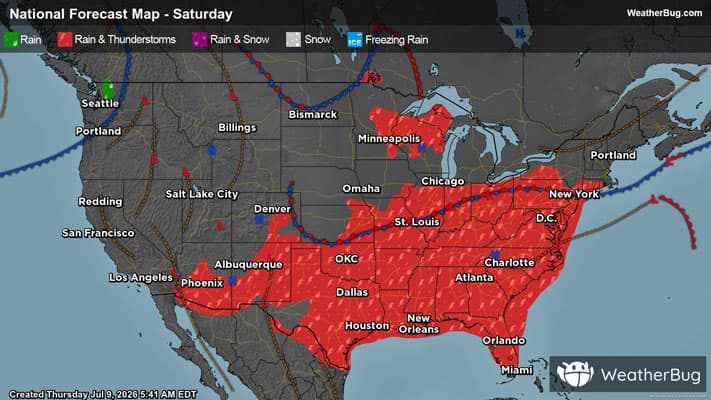
Over the next week, mostly dry conditions are expected across much of the western U.S., particularly west of the Continental Divide. The main exceptions are southeast Arizona and areas near the southern Arizona–New Mexico border, where rainfall could exceed 0.5 inches. The northern and southern Great Plains are also expected to remain largely dry and very warm to hot. Though, parts of the central Plains could see localized rainfall of more than an inch, especially southern Nebraska and northern Kansas.
Farther east, wetter conditions are expected across portions of the central and eastern U.S. Rainfall of around an inch or more is forecast for parts of the Southeast, Mid-Atlantic, Louisiana, Mississippi, Arkansas, and Missouri. The heaviest precipitation, totaling 1.5 to 3 inches, is expected from southern Illinois through southern Indiana, Kentucky, eastern Tennessee, and parts of West Virginia. Elsewhere, isolated showers may produce up to three-quarters on an inch of rain from Iowa into the Lower Great Lakes, while most of New England, particularly the southern half, is expected to remain mostly dry.
------
Source: U.S. Drought Monitor