

Arthur’s Moisture Delivers Significant Rainfall, Easing Drought Across the Southern U.S.
Moisture associated with Tropical Storm Arthur brought heavy rain to southeast Texas, Louisiana, Mississippi, Alabama, Georgia, and the western panhandle of Florida from June 15th to June 18th, resulting in widespread drought improvements. Rain totals of 4 to 8 inches or more were common across the Deep South, with higher amounts observed in several spots. Although flash flooding and lowland flooding occurred, overall impacts were muted by drought conditions, which until recently had spanned the South.
Farther north, a series of cold fronts sparked occasional showers and thunderstorms, resulting in localized wind and hail damage but maintaining favorable soil moisture reserves for summer crops in the Midwest. The Plains also received scattered areas of rain leading to some areas of improvement, but drought impacts remain on rangeland, pastures, and crops.
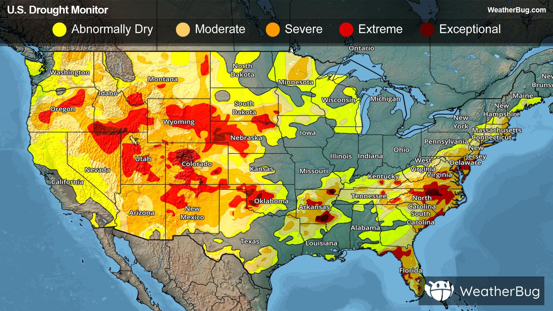
In the western U.S., hot, mostly dry weather prevailed, with deepening drought in many areas. Complications related to Western heat included heavy irrigation demands and a broadly elevated wildfire threat. Ongoing fires include the Cottonwood Fire in southwest Utah (over 60,000 acres), the Iron fire in central Utah (37,000 acres), and the Grapevine fire in southern Nevada (23,000 acres).
West
Hot, dry weather boosted irrigation demands and resulted in a broadly elevated wildfire threat. Drought deterioration was commonly observed across roughly the northern half of the region (from Washington and Oregon across Idaho to the northern and central Rockies), amid significantly above-normal temperatures and mounting water-supply concerns. Some of the West’s most significant drought - - with embedded pockets of extreme to exceptional drought (D3 to D4) - - stretched from Oregon to Wyoming, southward into portions of the Four Corners States. By June 24, at least a half-dozen active Western wildfires had burned more than 10,000 acres of vegetation - - three in Utah, two in Nevada, and one in Washington. Additionally, the U.S. Department of Agriculture reported on June 21 that statewide rangeland and pastures were rated 75% very poor to poor in Arizona, along with 63% in Colorado, and 60% in Wyoming.
High Plains
The area from the Dakotas across Nebraska and Kansas reported drought improvement or unchanged conditions, with a few exceptions. Streaks of heavy rain led to one-category improvement in a swath across central Nebraska and western and central Kansas. However, the rain arrived too late to help winter wheat and has only recently begun to revive drought-stricken rangeland and pastures. With the winter wheat harvest well underway (40% complete, nationally, on June 21), 46% of the crop was rated in very poor to poor condition. More than one-half of the crop was rated very poor to poor in Nebraska (83%), Colorado (63%), and Kansas (55%). On June 21, statewide rangeland and pastures were rated at least one-half very poor to poor in Nebraska (73%), Colorado (63%), and Wyoming (60%).
In contrast, drought deterioration was observed in parts of Colorado and Wyoming.
Midwest
Heavy rain grazed some of the lower Midwest’s remaining drought areas, leading to areas of improvement, especially in Kentucky. However, moderate to extreme drought (D1 to D3) remained in southern and southeast Kentucky, and moderate to severe drought (D1-D2) was noted in southeast Missouri and the Missouri bootheel. Meanwhile, the upper Midwest was a mixed bag of spotty improvement and deterioration. In Minnesota, there are pockets of moderate to severe drought (D1-D2) in the northern and southwest parts of the state.
In contrast, the middle portion of the Midwest saw rather wet conditions. As of June 21, according to the U.S. Department of Agriculture, statewide topsoil moisture was rated 43% surplus in Illinois, along with 36% in Missouri, 27% in Indiana, and 26% in Michigan. On that date, USDA reported that roughly two-thirds of the U.S. corn (68%) and soybeans (66%) were rated in good to excellent condition, reflecting mostly favorable Midwestern growing conditions.
South
Downpours related to frontal interactions with tropical moisture, including Tropical Storm Arthur, delivered drought relief but caused local flooding. In fact, the western and central Gulf Coast regions became mostly drought-free, following the latest deluge, with broad one-category improvement noted from eastern Texas into central and southern Alabama, as well as northern Arkansas and western Tennessee. By June 21, with periods of heavy rain still falling, statewide topsoil moisture in agricultural regions had increased to 35% surplus in Louisiana, according to the U.S. Department of Agriculture.
The region’s most significant remaining drought existed across much of Arkansas and environs, with over 60% of Arkansas in severe to exceptional (D2 to D4) drought. The western third of Oklahoma also remains in severe to exceptional (D2 to D4) drought.
Southeast
Heavy rain resulted in significant reductions in drought coverage and intensity across much of the Southeast. Rainfall was particularly impressive across the northern tier of Florida and central and southern sections of Alabama and Georgia, with many locations receiving more than eight inches of rain during the drought-monitoring period. The stunning Southern reversal from drought to wetness was capped by the remnants of Tropical Storm Arthur interacting with a stalled front. On June 21, the U.S. Department of Agriculture indicated that statewide topsoil moisture in agricultural regions was 34% surplus in Alabama, along with 33% in Georgia.
In contrast, conditions were unchanged in central and south Florida, and in portions of the middle Atlantic States. A significant drought footprint persisted in much of Florida, North Carolina, and Virginia. In fact, USDA noted on June 21 that statewide pastures were rated 53% very poor to poor in both North Carolina and Virginia. On the same date, North Carolina’s corn crop was rated 40% very poor to poor, highlighting both drought and periods of extreme heat. In southern Florida, prominent hydrological issues - - such as unusually dry wetlands, leading to wildfires - - were reflected by pockets of extreme drought (D3), despite scattered thunderstorms. Additionally, the stage on Lake Okeechobee stood at 9.70 feet on June 21, down 0.23 foot from one month earlier.
Northeast
Heavy rain across northern New England continued to chip away at lingering, long-term dryness (D0) and moderate to severe drought (D1 to D2). The most impressive improvement occurred across Maine. Through June 23, month-to-date rainfall rose to 4.98 inches in Portland, Maine. General drought improvement was also noted across West Virginia. Farther east, however, severe drought (D2) expanded in north-central Maryland, amid ongoing short- and long-term precipitation deficits. Through June 23, year-to-date precipitation deficits of more than 5 inches were observed in several Maryland locations, including BWI Airport.
Looking Ahead
In the Southwest U.S., unusually windy and very dry conditions will lead to dangerous fire weather conditions from June 25th to June 28th in Nevada, Utah, southwest Wyoming, western Colorado, Arizona, and northwestern New Mexico. Meanwhile, from the Plains to the northeast, the cool weather pattern will begin to break down during the weekend, as heat builds northeastward. During the next few days, triple-digit (100-degree) heat will be mostly limited to the southern High Plains and the Desert Southwest. Late in the weekend, however, temperatures could reach 100°F as far north as the upper Midwest and as far east as the Carolinas. Meanwhile, markedly cooler air will overspread the West. Increasingly showery weather will accompany the Western cool spell, particularly from the Pacific Northwest to the northern Rockies, although dry weather will continue in much of California and the Desert Southwest. Unsettled weather will also prevail east of the Rockies, except for hot, dry conditions in the western Gulf Coast region. Five-day rainfall totals could reach 2 to 4 inches or more from the central Plains into the Ohio Valley, and 1 to 2 inches in parts of Montana and North Dakota.
The NWS 6- to 10-day outlook for June 30 – July 4 calls for the likelihood of below-normal temperatures in much of the West, while hotter-than-normal weather will prevail from the Plains to the Atlantic Coast. Meanwhile, near- or above-normal rainfall across much of the country should contrast with drier-than-normal conditions in a few areas, including the Great Basin and portions of the Southeast and Intermountain West.