Back to forecast
Memorial Day Weekend Weather Preview
May 24, 2018 at 01:18 PM EDT
By WeatherBug's Rebecca Huff
Calling all beachgoers and grill masters! It’s time for the unofficial kick-off to summer but will Mother Nature cooperate this holiday weekend?
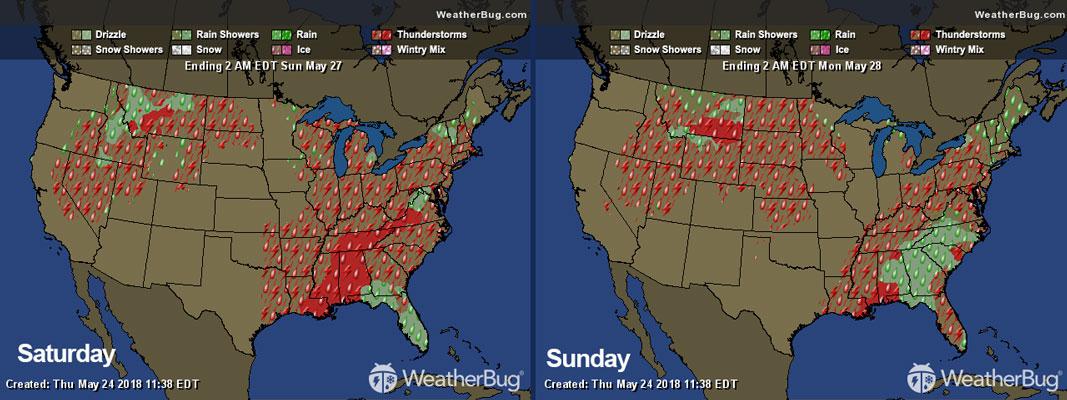
Saturday
Residents in the eastern half of the U.S. from the Mississippi Valley through the Eastern Seaboard will all have to keep an eye on the sky for showers and thunderstorms. Maybe bring the rain boots with you to that cookout just in case. On top of the thundershowers, highs will reach into the upper 80s and even 90 degrees -- perfect for opening the pool! The only communities in the clear from any wet and thundery weather are those in northern Vermont through Maine where the mercury only reaches the upper 60s and low 70s with sunshine.
Those in the Plains, form the Dakotas all the way into southern Texas will have a quiet Saturday. However, it appears Mother Nature thinks it is already late June as highs are pegged for the upper 80s to mid-90s. The triple digits will even be around for those in the southern Plains through New Mexico. If they aren’t already, several pools are likely to open as soon as possible ahead of the late-May sizzler.
Stormy skies are headed for the western High Plains, especially Montana and Wyoming. Those showers that follow the thunderstorms will be a welcome sight as highs reach the 80s and low 90s. The same heat can be expected along the valleys of the central and southern Rockies with cooler 60s across the higher elevations.
A few scattered showers and thunderstorms will hang around the northern and central Great Basin on Saturday thanks to a passing low-pressure system. Mild highs in the 60s and 70s will however make for a pleasant day for heading outdoors between storms.
The West Coast from western Washington through southern California will stay relatively quiet except for a few showers and thunderstorms along the Cascades. Snow is even on the menu for the Sierra Nevada as cooler air is funneled in thanks to the low pressure. Highs will reach the 50s and 60s along the coasts while the western interior mercury makes it into the 70s and 80s.
Sunday
The same wet song will be sung in the eastern half on Sunday. With a stationary front and a tropical disturbance working together, plenty of moisture will be funneled in and stretched along the Great Lakes and Northeast through the Southeast. Florida through the Carolinas will remain along the soggiest of areas as several inches of rain are set to fall. Highs will remain warm in the 80s. The exception will be Maine, where the mercury will only reach the 60s thanks to a cold front.
The Mississippi Valley through the southern Plains will have a few scattered showers and possibly a thunderstorm to watch. The rain will help cool things off as highs reach the hot 90s. The low 100s will continue to roast Texas, keeping those air conditioners running on overtime.
Stretching from the central Great Basin into the northern Plains, more thundery weather will pop-up throughout the late-morning and early-afternoon hours. Heading outdoors for the holiday celebration? Highs will continue to be a bit toasty in the 70s and 80s.
Sunscreen will be the main accessory needed in the western U.S. from the Pacific Northwest through southern California and the Southwest. With the pleasant clear skies, highs will also reach the mild 60s and 70s along the West Coast while the interior West and Desert Southwest bake in the 80s and 90s.