Back to forecast
Memphis Shatters April Rainfall Record 30 Years Ago
April 26, 2021 at 07:32 PM EDT
By WeatherBug Sr. Meteorologist, Chad Merrill
Late April is typically a volatile part of the spring season with violent storms erupting across the Southeast and Tennessee Valley. While hail, high winds and tornadoes make the press in April and May, one city in the heart of the Tennessee Valley was in the news 30 years ago for a slightly different reason.
Memphis, Tenn., is no stranger to an active weather pattern in April. As a matter of fact, April is historically the city’s second wettest month of the year, with 5.50 inches of rain. April is less than a quarter inch behind December, which averages 5.74 inches.
Climate averages provide a general overview of the rain and snow (primarily in winter) amounts expected each month because they are backed by 30-years of data, which is enough information needed to establish trends. However, unique weather patterns produce dips and surpluses in precipitation on a month-to-month and season-to-season basis. The spring of 1991 was one of those unique periods in time for Memphis.
Right out of the gate, an active storm track focused from the Rockies to the Tennessee Valley brought more than the city’s monthly average rainfall in the first twelve days of April 1991. The pattern didn’t let up for April’s second half either. All told, Memphis, Tenn., saw 19 days with a trace or more of rainfall and only 11 days with no rain.
April 27, 1991 was the icing on the cake with 2.82 inches of rain, which set the daily record for the date.
Once the final numbers were crunched, Memphis, Tenn., came away with 17.13 inches of rain in April, shattering the previous monthly record of 13.90 inches, originally established in 1872. Since then, only 2011 has come close to the April 1991 rainfall record with 11.76 inches of rain.
Once a weather pattern is established, it usually doesn’t break for a few weeks. The spring of 1991 was no exception to that rule in Memphis, Tenn. Besides April being the wettest fourth month of the year on record, rainfall records busted through the history books for the spring season. The city tallied 25.91 inches of rain from March 1 to May 31, making it the wettest spring on record.
Besides being in the hot zone for heavy rain in April, it’s also the month that southwest Tennessee historically seems the most tornadic activity. Tennessee averages eight tornadoes in April followed close behind by six tornadoes in May.
April 1991 was just a reminder to not only have a severe weather plan in place once the next dangerous thunderstorm strikes, but also to heed flash flood warnings. Never drive across a flooded road because the water is usually deeper than what it appears and water only a foot deep can float a vehicle. If a Flash Flood Warning is issued for your area, move to higher ground to avoid nearby rising water, especially if you live near a creek or stream or low-lying, poor drainage area that is susceptible to flooding during heavy rain events.
----
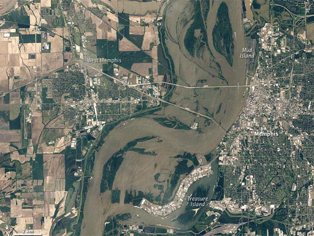
Story Image: Muddy water is seen from the Thematic Mapper on Landsat 5 between Memphis and west Memphis during flooding in May 2011. (Image courtesy of NASA’s Earth Observatory)
Memphis, Tenn., is no stranger to an active weather pattern in April. As a matter of fact, April is historically the city’s second wettest month of the year, with 5.50 inches of rain. April is less than a quarter inch behind December, which averages 5.74 inches.
Climate averages provide a general overview of the rain and snow (primarily in winter) amounts expected each month because they are backed by 30-years of data, which is enough information needed to establish trends. However, unique weather patterns produce dips and surpluses in precipitation on a month-to-month and season-to-season basis. The spring of 1991 was one of those unique periods in time for Memphis.
Right out of the gate, an active storm track focused from the Rockies to the Tennessee Valley brought more than the city’s monthly average rainfall in the first twelve days of April 1991. The pattern didn’t let up for April’s second half either. All told, Memphis, Tenn., saw 19 days with a trace or more of rainfall and only 11 days with no rain.
April 27, 1991 was the icing on the cake with 2.82 inches of rain, which set the daily record for the date.
Once the final numbers were crunched, Memphis, Tenn., came away with 17.13 inches of rain in April, shattering the previous monthly record of 13.90 inches, originally established in 1872. Since then, only 2011 has come close to the April 1991 rainfall record with 11.76 inches of rain.
Once a weather pattern is established, it usually doesn’t break for a few weeks. The spring of 1991 was no exception to that rule in Memphis, Tenn. Besides April being the wettest fourth month of the year on record, rainfall records busted through the history books for the spring season. The city tallied 25.91 inches of rain from March 1 to May 31, making it the wettest spring on record.
Besides being in the hot zone for heavy rain in April, it’s also the month that southwest Tennessee historically seems the most tornadic activity. Tennessee averages eight tornadoes in April followed close behind by six tornadoes in May.
April 1991 was just a reminder to not only have a severe weather plan in place once the next dangerous thunderstorm strikes, but also to heed flash flood warnings. Never drive across a flooded road because the water is usually deeper than what it appears and water only a foot deep can float a vehicle. If a Flash Flood Warning is issued for your area, move to higher ground to avoid nearby rising water, especially if you live near a creek or stream or low-lying, poor drainage area that is susceptible to flooding during heavy rain events.
----
Story Image: Muddy water is seen from the Thematic Mapper on Landsat 5 between Memphis and west Memphis during flooding in May 2011. (Image courtesy of NASA’s Earth Observatory)