Severe Storm Outbreak Eyes Central U.S. Tonight
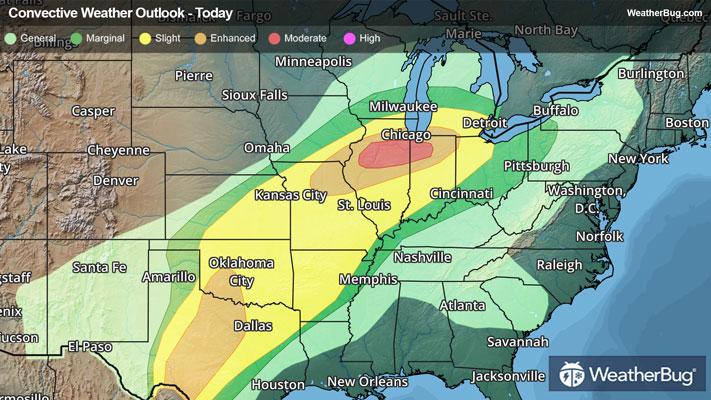
A severe storm outbreak will likely occur across the Midwest, with dangerous weather in the forecast from the Middle Mississippi Valley to the Texas-Mexico border. Large hail and a few intense tornadoes will be the primary risks.
Unseasonably warm, humid air stretching from Texas to north-central Illinois, Indiana, and Lower Michigan will clash with much cooler, drier air to the north of a warm and cold front attached to a pair of complex storm systems in the nation’s midsection this afternoon and evening. Combined with disturbances aloft, thunderstorms will quickly multiply and merge into clusters or lines over time later this evening and tonight.
Tornado Watches are in effect in southwestern Missouri to far northeastern Texas respectively, including cities such as Springfield, Mo., and Fayetteville and Fort Smith, Ark.
Isolated damaging wind gusts up to 80 mph, destructive hail larger than baseballs, and a few tornadoes are likely. A few intense, long-track tornadoes will be possible as well, particularly in the Enhanced and Moderate Risks issued by the government’s Storm Prediction Center. This includes cities such as Peoria, Pekin, Joliet, Chicago, and Bloomington, Ill., and the Dallas-Fort Worth metroplex to Abilene and Del Rio, Texas.
By early Wednesday morning, powerful thunderstorms will likely be rumbling from Lower Michigan and central Indiana and Illinois to Missouri, southeastern Oklahoma, and much of central and eastern Texas. Here, damaging gusts exceeding 60 mph, large hail, and a few tornadoes, including one or two strong tornadoes, will be possible. Cleveland to Columbus, Ohio, St. Louis, Springfield, Mo., Tulsa and Oklahoma City, Okla., Evansville, Ind., Wichita, Kan., and Little Rock, Ark., to Waco, Texas, could be impacted by this activity overnight.
Low pressure will organize in Lower Michigan on Wednesday before racing into eastern Canada by mid-afternoon. Dragging a cold front from the eastern Great Lakes to the Texas Gulf Coast, thunderstorms will be numerous from Pennsylvania and Ohio to Louisiana and Texas.
Shreveport, La., Memphis and Nashville, Tenn., Louisville, Ky., Cleveland and Columbus, Ohio, Pittsburgh, Philadelphia, Baltimore, and Washington, D.C. will be at risk for powerful storm encounter. Gusty winds and a few tornadoes will be the biggest problems attached to the intense weather, although a few instances of large hail cannot be ruled out.
Soaking rain, often in a short period, will be another impact to watch for underneath strong thunderstorms the next few days. Totals of 1 to 2 inches are likely for the Mid-South and Lower Great Lakes, with locally 2 to 3 inches or more possible in eastern Texas and southwestern Arkansas. This may lead to urban flooding, especially where poor drainage exists. If you approach a road covered in water, remember the old saying, “Turn Around, Don’t Drown!”
Make sure to know the difference between a watch and a warning should they be issued. A "watch" means that conditions are favorable for severe weather to occur, and to be on alert for any rapidly changing conditions. A "warning" means that severe weather is imminent, and you should act fast to remain safe.
The best way to remain safe is to stay prepared and informed about your local weather. Have a severe weather kit packed with a battery-operated radio, water, and non-perishable food items. Also, check the WeatherBug app frequently for any updates on today's severe weather. Remember, "When Thunder Roars, Go Indoors!"