Back to Hurricane Alerts
Mid-Atlantic, Great Lakes Snow Piles Up
December 14, 2025 at 03:07 PM EST
By WeatherBug Meteorologist, Keegan Miller
One final disturbance in what has been a parade of weather disturbances brought snow to the Ohio Valley, Mid-Atlantic, and southern New England late last night and earlier today. Lake-effect snow will continue downwind of the Great Lakes through the evening.
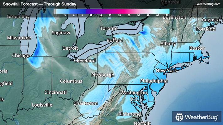
A weak but fast-moving low pressure system swept across the Northeast. A general 2 to 5 inches of snow fell last night and into this afternoon in cities such as Washington D.C., Philadelphia, and New York City. A few areas of 5 to 8 inches materialized in eastern Pennsylvania, New Jersey, and Long Island.
Behind the system, westerly to northwesterly winds will draw across the Great Lakes with a large difference between the cool lake temperatures and the frigid air temperatures. As a result, lake-effect snow bands will align over downwind areas of the lakes and the western Alleghenies, tucking locales into a bed of snow.
From today into Monday, snow accumulations will generally be in the 2 to 4 inches on southern and eastern shores, with 6 to 8 or more inches possible onto towns with the largest fetches of wind over the lakes. In the western Alleghenies, 2 to 4 inches are expected to drop on the higher peaks, with 1 to 2 inches along the spine from central West Virginia into southwestern Pennsylvania.
Winter Weather Advisories are in effect across the central Appalachians in West Virginia, parts of western Pennsylvania, northeast Ohio, and lake effect prone areas of western and northern New York.
Winter Storm Warnings have been issued for some sections of the high elevations of West Virginia. Lake Effect Snow Warnings are also in effect for portions of northeastern Ohio, northwestern Pennsylvania, and areas of New York just east of Lake Ontario.
It’s never too early to have a supply kit packed in case of inclement weather. A simple kit including a weather radio, water, blankets, batteries, and non-perishable food items will go a long way in the event of a power outage. It’s always best to avoid travel in rough weather as the roads will be dangerous.