Back to forecast
Mother Nature’s Hidden Winter Danger: Freezing Fog
November 19, 2021 at 12:10 PM EST
By WeatherBug Sr. Meteorologist, Chad Merrill
Freezing rain, sleet and refreezing of melted snow are major winter hazards for drivers, pedestrians and runners. Did you know that there is another hidden winter hazard, not related to winter precipitation, which can coat sidewalks and roadways with a layer of ice?
The main source for this winter hazard is typically a warm front. As warm air pushes over a dome of Canadian or Arctic air, freezing rain and sleet can instantly create an ice rink on driveways, walkways and roadways. This is especially true for surfaces untreated with anti-icing agents.
However, even after the frozen precipitation ends, icing can still develop on these surfaces. The reason—if the cold air is not completely dislodged, fog will likely develop. This is a common occurrence with warm fronts that displace Arctic airmasses in January and February.
Fog anytime of the year is a driving hazard because it significantly limits visibility and can be as dangerous as driving in a blizzard with near zero visibility. Freezing fog, however, is even more dangerous because it creates a slippery surface in an environment where it’s difficult to see more than a few hundred feet ahead. The National Weather Service will issue Freezing Fog Advisories when fog develops in a region where surface temperatures will drop below freezing.
Another perfect recipe for freezing fog is clearing skies and calm winds developing overnight after a winter storm has exited a region. As warm air radiates away from the ground and the temperature cools to its dew point, fog can develop. This type of fog is most common in valleys and if the ground temperatures are below freezing, the water droplets will freeze on contact.
Although freezing fog doesn’t weigh down powerlines and trigger power outages, it instantly coats driveways, walkways and roadways with a very thin layer of ice. Visibility in freezing fog is often under one mile. Besides reduced visibility while driving, it’s very easy to hit a patch of ice created by the fog, losing control of the vehicle in the process.
The standard thermometer shelter is 4 to 6 feet above the ground. Warm fronts can help displace long-standing Arctic air masses during the height of the winter season. Thus, resulting in roadway, walkway and driveway temperatures that are often colder than current temperature readings seen on weather reports.
Over time, an Arctic air mass will cool pavement temperatures far more than the air above it. The assessment of whether fog is freezing on contact can’t just be done by reviewing current air temperatures in and around your area. The best measure of road conditions is done by reviewing roadway temperatures through local Department of Transportation websites.
Unlike Ice Storm Warnings or Winter Weather Advisories which usually have a short life span, Freezing Fog Advisories usually span at least 8 hours. In a situation where a warm front is overtaking an Arctic air mass, freezing fog can linger for several hours to two days. Typically, this is the case before either the warm air wins out or another weather system comes along to stir up the winds, dissipate the fog and dry out the pavement.
Keep your WeatherBug sources active this winter to get the latest winter-related advisories, including Freezing Fog Advisories.
Source: NOAA
---
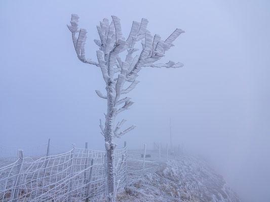
Story Image: Freezing fog is seen. (Courtesy of Pixabay.com)
The main source for this winter hazard is typically a warm front. As warm air pushes over a dome of Canadian or Arctic air, freezing rain and sleet can instantly create an ice rink on driveways, walkways and roadways. This is especially true for surfaces untreated with anti-icing agents.
However, even after the frozen precipitation ends, icing can still develop on these surfaces. The reason—if the cold air is not completely dislodged, fog will likely develop. This is a common occurrence with warm fronts that displace Arctic airmasses in January and February.
Fog anytime of the year is a driving hazard because it significantly limits visibility and can be as dangerous as driving in a blizzard with near zero visibility. Freezing fog, however, is even more dangerous because it creates a slippery surface in an environment where it’s difficult to see more than a few hundred feet ahead. The National Weather Service will issue Freezing Fog Advisories when fog develops in a region where surface temperatures will drop below freezing.
Another perfect recipe for freezing fog is clearing skies and calm winds developing overnight after a winter storm has exited a region. As warm air radiates away from the ground and the temperature cools to its dew point, fog can develop. This type of fog is most common in valleys and if the ground temperatures are below freezing, the water droplets will freeze on contact.
Although freezing fog doesn’t weigh down powerlines and trigger power outages, it instantly coats driveways, walkways and roadways with a very thin layer of ice. Visibility in freezing fog is often under one mile. Besides reduced visibility while driving, it’s very easy to hit a patch of ice created by the fog, losing control of the vehicle in the process.
The standard thermometer shelter is 4 to 6 feet above the ground. Warm fronts can help displace long-standing Arctic air masses during the height of the winter season. Thus, resulting in roadway, walkway and driveway temperatures that are often colder than current temperature readings seen on weather reports.
Over time, an Arctic air mass will cool pavement temperatures far more than the air above it. The assessment of whether fog is freezing on contact can’t just be done by reviewing current air temperatures in and around your area. The best measure of road conditions is done by reviewing roadway temperatures through local Department of Transportation websites.
Unlike Ice Storm Warnings or Winter Weather Advisories which usually have a short life span, Freezing Fog Advisories usually span at least 8 hours. In a situation where a warm front is overtaking an Arctic air mass, freezing fog can linger for several hours to two days. Typically, this is the case before either the warm air wins out or another weather system comes along to stir up the winds, dissipate the fog and dry out the pavement.
Keep your WeatherBug sources active this winter to get the latest winter-related advisories, including Freezing Fog Advisories.
Source: NOAA
---
Story Image: Freezing fog is seen. (Courtesy of Pixabay.com)