Back to forecast
Northern Plains, Midwest Under Severe Threat
July 15, 2024 at 02:12 AM EDT
By WeatherBug Meteorologist, Dan Rupp
Parts of the northern Plains into the Ohio Valley will be at risk for severe weather today thanks to a stubborn cold front.
A nearly stationary front draped over the north-central U.S. along with upper-level energy will be the catalyst for severe weather today. This cold front separates very warm, humid air to the south with cooler and drier air to the north. The collision of air masses will cause thunderstorms to develop throughout the day. Upper-level energy and strong winds aloft will enhance any thunderstorms that develop.
A Severe Thunderstorm Watch is in effect across much of North Dakota as well as northeastern South Dakota. A separate area in northern Illinois, central and northern Indiana and southwestern Michigan is also under a severe thunderstorm watch.
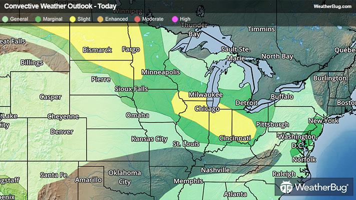
The government’s Storm Prediction Center currently has a Slight Risk for severe weather in two areas. The first is over northeastern Montana, all of North Dakota and northwestern Minnesota, while the other covers eastern Iowa, southern Wisconsin and northern Illinois into southwestern Michigan, most of Indiana and western Ohio. Cities within the Slight Risks include Minot, Bismarck and Fargo, N.D., Chicago, Indianapolis, and Columbus and Cincinnati, Ohio.
Very large hail (>2 inches) will be possible along with high wind gusts above 70 mph, but a tornado or two cannot be ruled out. Softball size hail and wind gusts greater than 80 mph were already reported earlier today and yesterday.
However, anyone from the Upper Mississippi Valley into the Lower Great Lakes and Ohio Valley should keep an eye on darkening skies. Cities such as Minneapolis, Des Moines, Iowa, Milwaukee, Detroit and Cleveland could see strong wind gusts exceeding 50 mph and small hail.
Make sure to know the difference between a watch and a warning should they become issued. A watch means that conditions are favorable for severe weather to occur and to be on alert for any rapidly changing conditions. A warning means that severe weather is imminent, and you should act fast to remain safe.
The best way to remain safe is to stay prepared and informed about your local weather. Have a severe weather kit packed with a battery-operated radio, water, and non-perishable food items should you be without power for long periods of time. Remember, “When Thunder Roars, Go Indoors!”
A nearly stationary front draped over the north-central U.S. along with upper-level energy will be the catalyst for severe weather today. This cold front separates very warm, humid air to the south with cooler and drier air to the north. The collision of air masses will cause thunderstorms to develop throughout the day. Upper-level energy and strong winds aloft will enhance any thunderstorms that develop.
A Severe Thunderstorm Watch is in effect across much of North Dakota as well as northeastern South Dakota. A separate area in northern Illinois, central and northern Indiana and southwestern Michigan is also under a severe thunderstorm watch.
The government’s Storm Prediction Center currently has a Slight Risk for severe weather in two areas. The first is over northeastern Montana, all of North Dakota and northwestern Minnesota, while the other covers eastern Iowa, southern Wisconsin and northern Illinois into southwestern Michigan, most of Indiana and western Ohio. Cities within the Slight Risks include Minot, Bismarck and Fargo, N.D., Chicago, Indianapolis, and Columbus and Cincinnati, Ohio.
Very large hail (>2 inches) will be possible along with high wind gusts above 70 mph, but a tornado or two cannot be ruled out. Softball size hail and wind gusts greater than 80 mph were already reported earlier today and yesterday.
However, anyone from the Upper Mississippi Valley into the Lower Great Lakes and Ohio Valley should keep an eye on darkening skies. Cities such as Minneapolis, Des Moines, Iowa, Milwaukee, Detroit and Cleveland could see strong wind gusts exceeding 50 mph and small hail.
Make sure to know the difference between a watch and a warning should they become issued. A watch means that conditions are favorable for severe weather to occur and to be on alert for any rapidly changing conditions. A warning means that severe weather is imminent, and you should act fast to remain safe.
The best way to remain safe is to stay prepared and informed about your local weather. Have a severe weather kit packed with a battery-operated radio, water, and non-perishable food items should you be without power for long periods of time. Remember, “When Thunder Roars, Go Indoors!”